What the inside of a tornado looked like as it passed through a Kansas town
Scientists are attempting to map the vortex’s internal structure and improve the ability to predict these weather phenomena
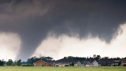
Selden is a town of fewer than 200 inhabitants on the banks of Interstate 83, which runs north–south from North Dakota to Texas as it passes through Kansas. The town is surrounded by wheat and corn fields that look as if they were drawn with a ruler, and circular wheat and corn fields that look as if they were drawn with a compass. In other words, Selden is an almost indistinguishable point in the geographic center of the United States — a vast tapestry of gold, brown, or green depending on the time of year — so flat that the horizon is everywhere.
In addition to wheat, corn, cattle, and horizons, what Selden also has in abundance is wind. “Wind of religious proportions,” as writer David Foster Wallace described it in his essay Derivative Sport in Tornado Alley. Foster Wallace said he was a poor tennis player but that he competed and won because, he wrote, he understood the wind.
On May 24, 2021, an EF1 tornado — the second level on the six-step Fujita scale — moved into Selden. EF1 means winds between 138 and 177 kilometers per hour (85-110mph) and moderate damage, capable of ripping off roofs, windows, and doors, uprooting trees, knocking down power poles and moving cars a few meters. That day, a team of atmospheric scientists from the University of California, Los Angeles, led by Roger Wakimoto, vice chancellor for research, documented the tornado’s internal structure with photographs, high-resolution video, and a mobile Doppler radar in what they say is the first experiment to employ all three technologies.
The nature of tornadoes is chaotic: they are violent, fast, and much of the wind behavior — tornado winds, as they are called — is hidden by the enormous cloud of debris they lift around them, the same kind of cloud that carried Dorothy off to the land of Oz. The team reconstructed the air motions inside this tornado — vertical and horizontal speeds, updrafts and downdrafts, tighter spins — by analyzing video and photographic frame-by-frame images of the objects flying around it: planks, branches, pieces of roof. It was like studying a river’s current by observing what it carries.
The study’s results, recently published by the American Meteorological Society, revealed the tornado’s internal structure in unprecedented detail: the tornado was almost symmetric, maximum horizontal winds were near the ground, and the strongest updrafts were at its front. This mapping of airborne debris was possible because, as the tornado moved over Selden, the cloud of objects remained relatively transparent, allowing them to also see objects flying in its rear and gain a complete view of the entire vortex.
Chasing tornadoes
Experts such as Wakimoto focus on one of the most important lines of tornado research today: what the vortex’s internal structure looks like and how near-surface wind speeds affect buildings and other structures they hit, and how these internal characteristics translate into damage. But there is another equally important area: improving short-term prediction.
Brice Coffer, a senior researcher at the European Severe Storms Laboratory (ESSL), has spent more than a decade trying to determine which storm is most likely to produce a tornado in the short term. “We do pretty well predicting them days in advance and highlighting the areas where they could occur. However, when there are multiple storms underway, we still have many limitations in determining whether one of them will produce a tornado in the next hour. There is a lot of randomness and chaos; many things have to align for one to form,” he said by videoconference.
Coffer, an American who worked on several of the VORTEX campaigns — the largest tornado research project ever undertaken and the inspiration for the film Twister (1996) — before coming to Europe, recalled: “I broke 10 windshields; at least once a week we had to replace one because of hail.” In the United States, the average tornado warning window is about 15 minutes from the time the alert is issued until the moment a community may be affected, but false alarms still account for about 75% of all warnings. That is precisely because “we still do not fully understand why some storms produce tornadoes and other very similar ones do not,” Coffer explained.
When the United States installed its next-generation radars in the late 1980s and early 1990s, statistics on warning times and false-alarm rates improved considerably, but over the past 10 to 15 years they have plateaued. In Europe the situation is much more confused, since each country records tornado data and issues warnings differently. One of the ESSL’s core goals is to create a unified database of extreme weather events in Europe, because without knowing when and where they occur it is impossible to identify the factors that favor their formation.
“The main difference with the U.S. is that storm environments in Europe generally present lower atmospheric buoyancy because Europe is at a higher latitude. That leads, on average, to weaker storms, which reduces the probability of tornadoes. Although tornadoes do occur in Europe, the factors needed for them do not coincide as often as they do in the U.S.,” Coffer concluded.
The invisible European tornadoes
About 300 tornadoes occur in Europe each year versus 1,200 in the United States, “but we know they are underreported,” explained Bogdan Antonescu, a researcher in the Faculty of Physics at the University of Bucharest and an expert in tornado climatology and extreme weather. “The problem is we know not all cases are recorded. Lacking instruments to collect the data, we depend on citizen observations. If you look at tornado distribution maps, you see they resemble population density maps: the more people, the greater the likelihood someone will observe and report a tornado. Very few countries have long data records — Spain has a very good database, Germany does too. But we do not know the exact number of tornadoes; what we do know for sure is that it is underestimated,” he continued.
According to these reports, most tornadoes in Europe would occur during summer in Central Europe, with northern Italy a particularly prone area. The Mediterranean region also sees many waterspouts and tornadoes, especially in autumn or early winter, since the Mediterranean Sea remains warm.
But that would only be part of the phenomenon. “If you look only at Spain or Romania, it seems very rare. But when data are aggregated and all of Europe is analyzed, you see it is not so infrequent. That may need to change; in fact it has changed over the last decade — more people are now working in this field here, trying to understand local conditions that favor tornadoes. We also know climate change influences extreme weather, so we need to better understand what is happening now,” Antonescu concluded.
With that aim, the ESSL is preparing a major international research campaign in the Alpine region focused on storm intensification between mountains and plains. The project will bring together universities, mobile radars, and scientific teams in parts of northern Italy, Austria, and Germany — areas considered hot spots for severe storms and hail.
Sign up for our weekly newsletter to get more English-language news coverage from EL PAÍS USA Edition