How to detect ancient buried cities without any digging
A team from southern Spain has become a leader in the use of new technology to map out underground sites; in just a few years it has explored six Roman cities and uncovered a Punic port

In just a few days, the Spanish archeologist Lázaro Lagóstena can figure out the complete layout of streets, buildings and ports in ancient cities that were swallowed up by the earth centuries ago. And he can do it without any digging.
It’s been years since Lagóstena, a professor of ancient history at Cádiz University (UCA), last used trowels, spades and brushes. Instead, he applies what he terms “the archeology of the future” to locate, say, a necropolis under a field of cereal. He can even determine how many cubic meters of sand would have to be extracted in order to reach it.
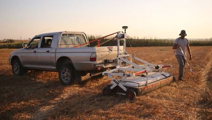
This kind of archeology is already a reality at UCA’s Geodetection Unit, which Lagóstena has been coordinating since 2016. His team routinely uses technologies such as ground-penetrating radar, drones and magnetometers – devices that measure magnetic fields – and over the years it has become a leader in this non-destructive way to interpret a country’s archeological heritage.
“I don’t think there is another research team in Europe that has been able to study six Roman cities in such a short period of time, and that’s if we limit ourselves to that particular historical period, because we have done even more,” says Lagóstena proudly.
In the space of five years this group of between eight and 10 researchers, depending on the number of students in training, has managed to reconstruct the hidden urban layouts of the Roman cities of Hasta Regia (today’s Jerez de la Frontera, in Cádiz province), Ilici (Alcudia, Elche), Libisosa (Lezuza, Albacete), Balsa (Luz de Tavira, in Portugal’s southern Algarve region), Arva (Alcolea del Río, Seville) and Calduba (La Perdiz, Arcos, Cádiz). And there is another project underway in Flavia Sabora (Cañete la Real, Málaga).
But the team’s findings go well beyond ancient Roman cities: they have over 60 projects to their name, some of them commissioned by public and private institutions. Some of them include helping locate mass graves containing victims of the Franco regime that followed the Spanish Civil War (1936-1939).
The use of non-invasive technology in archeology is not new, nor is it exclusive to Lagóstena’s team. But the UCA’s Geodetection Unit has shown a unique capability for detection and interpretation. “There are private companies out there, but not with as much technology,” notes the professor. “This used to be a field for geophysics, where experts would call in historians and archeologists. We, on the other hand, are experienced across disciplines and able to provide interpretation. Our leadership stems from the fact that no other university in Spain has this many resources.”
Lagóstena had not imagined any of this when, back in 2003, he began working on archeological research tied to Geographic Information Systems (GIS), a set of tools that can link a vast amount of data that’s been georeferenced and positioned on maps. It was then that he first applied for a national program of infrastructure and scientific equipment in order to build up the Seminario Agustín de Orozco department at UCA.
Lagóstena explains how a ground-penetrating radar works (Spanish audio).
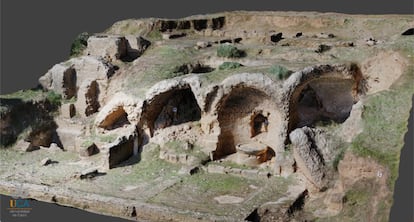
But the real turning point for the unit came in 2016, when it secured funding for its first large ground-penetrating radar. Despite initial misgivings about how useful it would be, in just two test runs the device was able to locate and map out the largest known Punic-era port in the Mediterranean, lying under a cultivated field adjacent to the Doña Blanca archeological site, in El Puerto de Santa María (Cádiz).
Since then, the unit has secured four more investment projects and acquired technology worth €1.8 million. It now functions as a peripheral service of UCA, and has the independence to enter into contracts with third parties that have already generated revenues of €250,000. “We’re being hired by other universities, provincial authorities, museums, local governments and companies. We are competitive because we don’t speculate with the quotes, we just charge enough to cover costs and generate some income for the researchers,” says Lagóstena.
The first step in any survey work is usually carried out by drones, which help identify areas of interest and geoposition their working space. The radars – they have five different ones – trace the urban itineraries under the ground to a depth of up to four meters. Their two magnetometers (soon to be four) identify spots where there was combustion in the past, such as a necropolis or a ceramics factory. The team is now planning to buy seismographs and tocographs that will allow them to reach deeper cavities, reconstruct geological layers and even differentiate between human and natural elements lying under the ground.
For Lagóstena, discovering the port of Doña Blanca remains one of his biggest sources of satisfaction. The public interest around this discovery was such that the regional parliament of Andalusia last month unanimously approved a proposal to start negotiations with the current owner of the land with a view to purchasing it and exploring the area further.
The work of the UCA researchers not only yields information about ancient urban structures, it also helps delineate physical areas that should get legal protection and draft appropriate management methods.
“In history we need information. Dig-based archeology is expensive and certain sources of information are now depleted. This is the future,” says Lagóstena, underscoring that technology-based archeology delivers more data in a shorter time and at a lower cost, making it possible to tackle larger territorial investigations that also address issues such as past interaction with the landscape through agriculture and water management.
“We are creating information databases with the experiences of the past. All pre-industrial societies were necessarily sustainable, and if you recover the way they worked, you are moving in a direction that is necessary in the present.”
English version by Susana Urra.


