The search for Hannibal’s elephants on the Tagus River
Research shows that the town of Driebes in Guadalajara province could be where the battle between the Carthaginians and the Carparthians was fought in 220 B.C.

The year was 220 B.C. and the young Carthaginian general Hannibal Barca had to return to his winter quarters in Qart Hadasht – now Cartagena in southeast Spain – after taking Helmática – now Salamanca in the northwest of the country – from the Vettones tribe. It was spring or summer, and the 27-year-old and his troops had to overcome two obstacles to get to their destination: firstly, the wide rivers and high mountains that were difficult for their 40 elephants to cross; the secondly, the hostile local Carpetani, Vettone and Olcade tribes, who sought revenge for the destruction of their crops and cities.
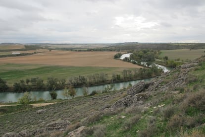
With just 25,000 soldiers, Hannibal managed to defeat 100,000 enemies. Nobody knows where exactly this battle took place, only that it happened somewhere along the banks of the Tagus River, which stretches 1,007 kilometers from the province of Teruel in Spain to Lisbon in Portugal.
Some, being swept in the direction of the enemies by the current filled with rapids, were crushed by the elephantsRoman historian Titus Livius
Now, an interdisciplinary study called Historical, Archaeological and Geological Data for the location of the Battle of Hannibal on the Tagus (220 B.C.), undertaken by archaeologists Javier Fernández from the Caraca-Driebes Archaeological Team and Emilio Gamo from the National Museum of Roman Art as well as geologists Miguel Ángel Rodríguez-Pascua, Andrés Díez-Herrero, María Ángeles Perucha and José Francisco Mediato from the Spanish Geological Mining Institute (IGME), has put forward a proposed a more precise spot. According to the study, the battle could have taken place between the towns of Driebes and Illana in Guadalajara province.
The new hypothesis could put an end to 200 years of experts arguing between various locations, including Toledo, Talavera de la Reina, Aranjuez, Colmenar de Oreja and Fuentidueña. Previous calculations were based on the description of the battle by the Greek historian, Polybius of Megalopolis and the Roman author, Titus Livius, though in many cases, their theories failed to correspond with ancient descriptions or with the archaeological evidence.
The new study not only takes these descriptions and pieces of evidence into account, it also considers the physical characteristics of the Tagus and the most logical route that Hannibal would have taken to return to his winter quarters in Cartagena.
The authors of the study are convinced that Hannibal used an ancient route which would later be improved by the Romans, joining Complutum, now Alcalá de Henares in Madrid region, to Carthago Nova, now Cartagena in Murcia, crossing the Tagus River close to Driebes, not far from Carpentani fortified settlement of Caraca. “The decision to attack Hannibal there was made by the Carpetani, as they knew the area well and it would also give them a leadership role within the coalition formed with the Vettones and Olcades,” explains Emilio Gamo.
The authors of the study are convinced that Hannibal used an ancient route between what is today Alcalá de Henares in Madrid region and Cartagena in Murcia
But the local tribes did not reckon with Hannibal’s strategic genius. The Carthaginian general placed his troops at the river fords, which were the only places that could be crossed on foot, forcing the Carpetani to funnel more troops towards these strategic points, and so to lose their numerical advantage as the space they had to fight in was greatly reduced.
To force them to cross, Hannibal also built a defensive wall parallel to the riverbed while placing mainly cavalry at the fords. Behind the wall, he placed the infantry and most of the elephants. When the Carpetani tried to cross the river, they were dragged to their death by the current or killed by the Carthaginians on horseback, who were able to manage the current more easily than those on foot. The depth of the river was 1.5 meters in places and the speed of the current could be as fast as one meter per second. This was confirmed by Titus Livius. “Some, being swept in the direction of the enemies by the current filled with rapids, were crushed by the elephants,” he wrote, referring to a phenomenon that occurs in the parts of the river that twists and bends “where the spiraling path of the water sends a floating object from one bank to another.”
The recent study also points out that “the dynamic of the current in bending rivers is characterized by the extreme variability [of the riverbed] over time.” This suggests that it would be hard to establish the battle was in the vicinity of Driebes and Illana and not elsewhere as the winding course of the river could well have changed in the intervening 2,200 years. However, the report also explains that, to a large extent, tectonic and geomorphological factors have determined the river dynamics in Driebes. This is due to the effect of different geological factors that make it possible for the fords to survive, such as the existence of faults with quaternary tectonic activity in the last two and a half million years. “These factors make it likely that the fords we see now to be probably the same, or in a similar location, as those existing in Hannibal’s time,” says the report.
Hannibal crossed the river and attacked the barbarians, putting to flight a force of more than one hundred thousandGreek historian Polybius
Moreover, geomorphological research carried out around Caraca reveals the existence of a quadrangular structure that is possibly man-made, which could be linked to Hannibal’s defense wall, while a furrow in front of it could have been his frontline trench. A spot called El Jardín hill could also have played an important role in the battle. From this hill, located to the southeast of the defense wall, the general would have been able to observe the entire battle scene as well as the Caraca fortified settlement. What’s more, the hill could have been used to hide his escort and light cavalry from the enemy.
With the Carpetani troops already in disarray, and many having lost their lives in the river, Hannibal decided to go on the offensive. “Finally, Hannibal in his turn crossed the river and attacked the barbarians, putting to flight a force of more than one hundred thousand,” wrote the Greek historian, Polybius.
The recent study is part of a series of investigations carried out on the Carpetani-Roman city, with the support of the Castile-La Mancha regional government, the Guadalajara provincial government and the city councils of Driebes, Illana and Brea de Tajo, as well as the Friends of the Guadalajara Museum Association.
The study also makes clear that any future archaeological campaigns it carries out will include a systematic survey of the area with a view to locating evidence left by the Carthaginian army, including the bones of elephants, although neither the Greek nor Roman authors mention elephant fatalities. “Our proposal is a working hypothesis just now,” says Gamo.
An avenue, an aqueduct and 27 blocks
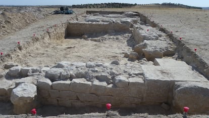
The first archaeological surveys on the Carpetani-Roman city of Caraca were carried out in the early 1980s, prompted by the 1945 discovery of the so-called Treasure of Driebes, consisting of a set of Carpetani jewels and silver weighing almost 14 kilograms.
But it was not until 2016 that the project was tackled systematically. Using geophysical techniques, it was then established that the city covered eight hectares during the Imperial Roman period (100-200 AD). The study, The Public Baths of Caraca and their Urban Context, written by the archaeologists Emilio Gamo and Javier Fernández Ortea, also found that the city had a forum and baths and that the water supply reached it through a canal measuring around three kilometers long, 113 meters of which can still be seen today. From the 1st century AD, the city was built around a wide avenue that ran in a northeast-southeast direction, cutting it in two.
Eighteen perpendicular streets came off the avenue, further dividing the urban landscape into 27 blocks. This has enabled experts to determine that the number of inhabitants was close to 1,800 and that each had 61.6 liters of water per day from the aqueduct, although only some of the water was for human consumption.
Similarly, the research team has managed to calculate the dimensions of the forum, which would have been 1,330 square meters. It was rectangular in shape with a building, possibly the basilica, to its rear. To the east of the forum, a two-story public building with a portico and two taverns has been located. And to the south, the ground penetrating radar has detected a structure of about 25 square meters, which was possibly a small temple facing the main avenue.
English version by Heather Galloway.


