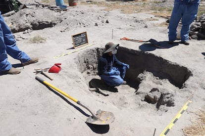
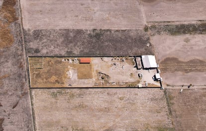
Mexico’s Izaguirre ranch: ‘High concentrations of ash’ suggest the presence of clandestine crematoriums
A study, to which EL PAÍS has had access, identifies alterations at the Jalisco site where relatives of missing persons have reported discovering huge quantities of bones
A study conducted by researchers from the Mexican government’s Secretariat of Science, Humanities, Technology, and Innovation, to which EL PAÍS has had access, has identified “high concentrations of ash” and hydrocarbon smoke at the Izaguirre ranch in Teuchitlán in Jalisco in 2019, years before its links to criminal activities were discovered. In recent weeks, the Mexican executive, led by President Claudia Sheinbaum, has indicated that the ranch was used as a training center for the criminal group Jalisco New Generation Cartel (CJNG) and has also revealed that the group killed and tortured people there.
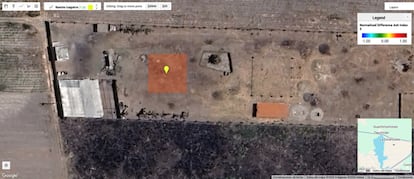
The satellite images analyzed show ashes in the exact locations on the ranch where relatives of missing persons reported, in early March, the discovery of clandestine crematoriums, following the finding of hundreds of bone fragments at the site. The group of relatives, Guerreros Buscadores de Jalisco (Warrior Searchers of Jalisco), has claimed that the ranch functioned as an extermination center — an expression the government has avoided using. This stance that has sparked significant controversy in Mexico, which has suffered from extremely high levels of violence for over two decades.
The study, submitted this week to the Jalisco State Search Commission, was not publicly known. In light of what happened in Teuchitlán, researchers analyzed hundreds of images from the European Space Agency’s (ESA) Sentinel-2 satellite to determine the presence of ash and smoke plumes at the ranch. To do so, they used a platform designed by the Science Ministry’s Center for Research in Geospatial Information Sciences (CentroGeo), which has participated in other high-profile investigations, such as the Ayotzinapa case.
On the platform, CentroGeo activated its own measurement tool, the NDAI5, which detects unusual concentrations of ash using shortwave infrared layers from satellite images — wavelengths not visible to the human eye. To ensure accuracy, they filtered out all images containing clouds. The researchers then identified a significant event on February 22, 2019. On that day, Sentinel-2, which captures a range of colors invisible to the human eye, including shortwave infrared, passed over the ranch. When applying the NDAI5 tool, a sharp peak in ash concentration was immediately evident.
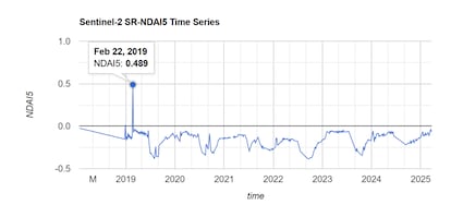
And not only that. In the standard image, without the infrared layers, they also noticed a “black smoke trail” emanating from the Izaguirre Ranch. The combination of the high concentration of ash in the area in front of the ranch — where the Search Warriors reported finding clandestine crematoriums — and the black smoke trail, which investigators firmly link to “the burning of hydrocarbons such as gasoline, diesel, and tires,” supports one of the prevailing theories about the ranch’s use in recent years: that it was an extermination center. The fact that this event occurred in 2019 raises a troubling question: How long were criminals using the ranch for these activities?
José Luis Silván, one of the study’s authors and a member of CentroGeo, says: “Although we can’t definitively say they were burning bodies, since those ash traces could be produced in several ways, considering other evidence and the current situation, there is a good chance that this is the case.” Regarding the presence of smoke in the ranch, located in an agricultural area, Silván adds that after reviewing hundreds of satellite images, they are certain that the black trail captured on February 22, 2019, was caused by a bonfire involving hydrocarbons, which took place inside the ranch — an area that, as Silván notes, had no agricultural activity.
Data from other satellites consulted by EL PAÍS further support the study’s conclusions. NASA’s Fire Information System (FIRMS), for example, shows that fire activity in the ranch’s vicinity occurred over the 15 days leading up to the detection of the ash peak. According to the tool, fire detection began on January 26, 2019, and continued consistently until February 9.
Gabriela Belaunzarán, a geoinformatician and space analyst, argues that, based on the evidence of cremation found by search groups and the identification of ash, the fires detected by NASA satellites over the two-week period may correspond to a controlled blaze, intentionally fueled and sustained. However, unlike Sentinel-2, FIRMS images do not provide enough detail to determine whether the fires occurred within the ranch or its immediate surroundings.
Experiments with pigs
The study is based on several years of work. In 2021, the National Search Commission, under the Ministry of the Interior, funded a series of experiments in collaboration with CentroGeo, aimed at developing “indexes for the detection of substances with applications in forensic searches.”
By that time, Mexico had already encountered hundreds of clandestine graves across the country and had experience with places where criminals had burned or dismembered their victims. Notable examples include La Gallera in Baja California, where Santiago Meza, alias El Pozolero, dissolved hundreds of bodies over the years, and the El Limón ranch in Veracruz, where alleged members of the Jalisco New Generation Cartel killed and dismantled five young men who disappeared in 2017.
The goal of the experiment was to explore tracking methods beyond the ongoing efforts of groups of relatives searching for missing persons across the country. These relatives, who have been the driving force behind the discovery of this tragedy, are searching for more than 115,000 missing individuals, 15,000 of whom are from Jalisco.
Researchers set to work on the project. “Pig remains were burned to simulate the presence of human tissue, using materials commonly employed by criminal groups to dissolve human bodies (such as caustic soda, lime, and muriatic acid, among others),” the study states. “With this, a series of indices were designed [...] of which the NDAI5 index was the most suitable for use with Sentinel-2 images and for detecting the presence of ash.”
In the experiments, the researchers used their own camera, which was capable of capturing numerous “spectral bands” — colors invisible to the human eye — unlike Sentinel-2, which captures only “12 or 13.” This greatly facilitated the research and enriched subsequent analyses, allowing the identification of specific fuel traces, among other findings.
It also resolved the issue of cloud interference by using ground-level drone cameras. These efforts ultimately led to the creation of various measuring tools, some for ash concentration and others for detecting fuels. With Teuchitlán as a focus, the researchers began a process of trial and error until they discovered that one of the meters, the NDAI5, worked particularly well with Sentinel-2.
The study should be understood as a modest reflection of what happened at the ranch and across the Valles region of Jalisco, where other similar training centers linked to the CJNG have been discovered. Silván notes that since January 2018, when the satellite began sending data, it has located “8,000 anomaly points” in the region — areas with “very high ash concentrations.”
Many of these points clearly indicate agricultural activities, especially considering the color of the smoke— white or gray. However, “every now and then, we do find a black one. And when you go to the property on the satellite image, you see a garbage dump or a vacant lot, with no agricultural activity, and they are suspicious. We have already shared this data with the state search commission,” the expert explains.
It’s also true that Sentinel-2 only sends information every six days, unlike, for example, NASA’s system, which sends information daily. Some of the images in the study were discarded due to cloud coverage, leading to information gaps of 12 days or more. This opens up many possibilities, especially when cross-referencing this data gap with the information gathered by NASA’s FIRMS over the years. While NASA’s system provides daily updates, it does not offer the same level of detail as the European satellite.
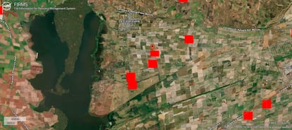
In addition to the data from January and February 2019, NASA’s satellites have identified other heat events near the Teuchitlán ranch in recent years. At times, the coordinates provided by FIRMS fall within the property, while other times they are located outside. The margin of error for these satellite measurements is typically a few dozen meters.
The closest fire detections to the ranch, according to NASA’s tool, occurred on the following dates: May 13, 2021 (with fire activity lasting 19 days), March 15, 2023 (23 days), January 22, 2024 (two fires, one lasting two days and the other 30 days), and February 2, 2025. In the last case, fires were recorded at multiple points around the property, with heat emissions lasting between 20 and 30 days. Shortly after that, during the first weekend of March, the ranch’s discovery made national headlines.
Sign up for our weekly newsletter to get more English-language news coverage from EL PAÍS USA Edition


