An extinct branch of the Nile explains the enigmatic location of the Egyptian pyramids
A new study locates and maps an ancient arm of the river that flowed through the desert area where the famous monuments stand today
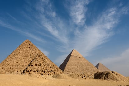

Most of the pyramids of ancient Egypt are clustered in a narrow strip of desert that stretches along the foothills of the country’s western desert plateau. It is taken for granted that these monumental structures were built near waterways that facilitated the transport of building materials and labor. But today the Nile, which is the only river that waters this inhospitable land, flows miles away. And its ancient branches, including the one that should explain the concentration of pyramids in a strip that is now in the middle of the desert, remain poorly understood.
In an attempt to solve this enigma, a team of researchers from several countries recently identified segments of a major extinct branch of the Nile, which they have dubbed the Pyramid Arm, that runs precisely through the area. Using satellite radar imagery, deep soil drilling and geophysical analysis, the group has been able to study the part of the Nile Valley next to the pyramids. And after extensive research, published last week in Nature, they argue that this branch of the river was fundamental to the construction of the iconic Egyptian structures.
“The discovery of this ancient branch, near the site of the pyramids, indicates that it indeed played a key role in the transport of the huge building materials and workers needed for their construction,” says Mahfooz Hafez, of the National Research Institute for Astronomy and Geophysics of Egypt (NRIAG) and one of the members of the team. In the opinion of the specialist, the extinct arm was part of a “river transport superhighway.”
Over the last millennia, the landscape of the Nile Valley as it passes through Egypt has undergone major changes. The study notes that about 12,000 years ago, during the so-called African humid period, the arid Sahara Desert became a savanna-like environment with extensive river systems due to a global rise in sea levels. At that time, the Nile had secondary branches running through its alluvial plain, and human life was not yet concentrated in the valley due to high water levels.
This wet phase in the region gradually came to an end around 5,500 years ago, pushing more and more people to move to higher ground on the edges of the Nile Valley’s alluvial plain, which was still bathed by several meandering branches of the river. During that transition came the period of Egypt’s Old Kingdom, around 2,600 B.C., when the first pyramids were built.
Then, as now, the Nile was the main source of life for Egypt. But with the passage of time, and the gradual desertification of the region, its central course continued to move towards its base and its secondary branches dried up, abandoning ancient human settlements in increasingly remote latitudes. Where exactly those branches of the Nile flowed and what they looked like, however, remains partly a puzzle.
Studies have been carried out in the past to try to locate these ancient branches of the Nile, and recent research had detected a river branch and a marsh-like environment at the foot of the pyramids of Giza. The recently published work reinforces the existence of a long-lost river branch, and it is the first to provide a map of that environment in the desert belt where the pyramids are concentrated. It also provides new clues as to why they were erected in their current locations and how the ancient Egyptians accessed their complexes.
“Studies had been conducted to uncover ancient buried channels of the Nile, but this time we turned our attention to understanding the relationship between the river and the pyramids, and why they are all distributed on the west bank of the Nile,” says Hafez.
In search of lost temples
By analyzing radar images, researchers have been able to identify that the Pyramid Arm was located between 2.5 and 10 kilometers (1.5-6.2 miles) west of the modern course of the Nile. It was between two and eight meters deep, 200 to 700 meters wide, and stretched for about 64 kilometers (40 miles), bordering some 30 pyramids.
The pyramids of ancient Egypt were built in complexes with other structures, including a relatively remote temple on the banks of a body of water connected to the rest by a causeway. The study notes that these temples acted as river ports, and has determined that the five that have partially survived to the present day are located along the banks of what was the river branch of the pyramids, and that all the causeways run perpendicular to its course. The researchers point out that the finding could help to locate other temples that remain buried. “We believe it will open the door to excavation along the Pyramid Arm to uncover more archaeological sites and perhaps lead to a major find in the future,” notes Hafez.
The researchers also propose that the location of these temples may prove useful in determining the evolution of the water levels of the branch. The rhomboid pyramid and the red pyramid at the Dahshur complex, south of Cairo, are located deep in the desert, and radar data reveal that their temple-port stood opposite the bank of an extinct channel of the Pyramid Arm. In contrast, the pyramids of the Fifth Dynasty, circa 2,500 to 2,350 B.C., are located at low altitudes and closer to the alluvial plain, indicating low water levels. The causeways of the great pyramids of Giza, on the other hand, flow into a sort of fluvial bay that connects with the Pyramid Arm, and the largest of the three, the great pyramid of Cheops, seems to connect directly with the recently located branch of the river.
Sign up for our weekly newsletter to get more English-language news coverage from EL PAÍS USA Edition


