A branch of the Nile that disappeared 2,500 years ago reveals clues about how the Giza pyramids were built
A study that reconstructed 8,000 years of the river’s history sheds new light on the important role it played in the construction of the monumental pharaonic tombs


The construction of the imposing pyramids of Giza 4,500 years ago along the western bank of the Nile is one of the world’s greatest feats of engineering, and one that continues to intrigue those who want to understand how the ancient Egyptians built them.
Most experts acknowledge that the pyramid builders used an ancient branch of the Nile River to transport the heavy construction materials and supplies they needed. But the river currently flows almost five miles (eight kilometers) east of the pyramids, and little is known about how that stretch of land has changed over the centuries.
To better understand this part of the puzzle, a group of scientists reconstructed 8,000 years of the Nile’s fluvial history through the Giza plateau by analyzing sediment from the area, and demonstrated that the water levels of that vanished river branch were ideal for erecting the pyramids.
“[These analyses] enabled us to produce for the first time a good, approximate record of the evolution of vegetation [in the area], and to estimate the proximity or distance of the Nile to the pyramids. It’s very new,” said Christophe Morhange, a geomorphologist with Aix-Marseille University in southern France, and one of the authors of the study published in the PNAS (Proceedings of the National Academy of Sciences) scientific journal.
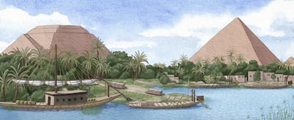
The study notes that to build the pyramids of Giza, the engineers of the Fourth Dynasty of Egypt (2613-2494 BC) must have relied on an ancient branch of the Nile called the Cheops or Khufu branch, which flowed along the western bank of the Nile’s alluvial plain. The ancient Egyptians used the water from this branch to build an ingenious network of canals and basins (as well as a little-known harbor) at the base of the Giza plateau, where the three pyramids still stand today.
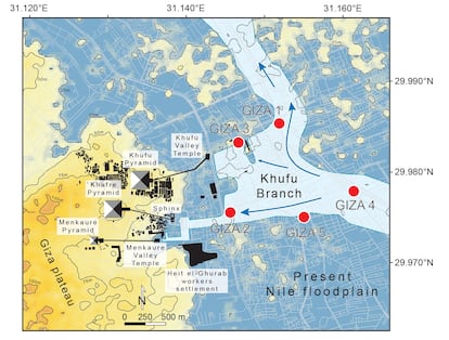
Several archaeological digs and urban construction projects in the area have turned up evidence supporting the existence of the Cheops branch and the surrounding water infrastructure. In 2013, papyrus documents dating from the time of Pharaoh Cheops were discovered along the coast of the Red Sea. The documents described a harbor at the base of the Giza plateau, as well as the transportation of construction materials for building the pyramids.
In order to better understand the landscape that facilitated the construction of the pyramids, the team led by Morhange extracted sediment samples from two boreholes drilled 50 feet (15 meters) deep into the Giza alluvial plain where the Cheops branch is thought to have passed. The team then analyzed the samples in search of pollen spores buried for thousands of years that would enable them to reconstruct the site’s vegetation history.
The researchers found 61 plant species, which they grouped into various vegetation patterns by proximity. Some were species commonly found on the banks of the Nile, while others were carried by the river from the tropical areas of the Nile watershed. A third group of species were indicative of a permanent body of water. The team then identified changes in area water levels over the millennia, based on the quantities of aquatic plant species found relative to other terrestrial species.
“We used these vegetation patterns to identify periods with wetter conditions around the Cheops branch, indicating higher [water] levels. These wetter conditions correlate with higher quantities of plant species typically found on the banks of the Nile – tropical nilotic taxa – and [species] revealing the presence of a permanent body of water,” said Hader Sheisha, an environmental geographer with Aix-Marseille University and one of the study’s authors.
The study concluded that although the Giza area was slowly becoming more arid when the three pyramids were being built by Cheops, Chephren and Mycerinus, the water level of the Cheops branch was still high enough to facilitate their construction. The Cheops branch’s highest water levels were recorded during the African humid period when North Africa and much of today’s Sahara were very wet, and began to decline around 3550 BC. This is consistent with the evidence of human settlements along the east bank of the Cheops branch during this same period, according to the study.
When the pyramids were being built, however, the Cheops branch’s water level had dropped to 40% of its historical maximum, according to the study. By the time Tutankhamun ascended to the throne in 1332 BC, the Cheops branch had already been declining for centuries. When Alexander the Great arrived in Egypt in 332 BC, at the beginning of what the Ptolemaic period, the Cheops branch was already “extremely low.”
“One of the study’s main contributions is that it shows that sediments are fundamental for understanding [a process] between society and nature over the long term. Nile sediments are crucial contextual indicators for archaeological excavations. They are as important as the monuments themselves,” said Morhange.


