Mexico urges respect for treaties after Texas seizes nine islands on Rio Grande
Border state authorities authorized the Texas National Guard to access these territories, arguing the need to maintain the southern border’s operational security. Mexico’s foreign ministry says island ownership is the remit of the International Boundary and Water Commission
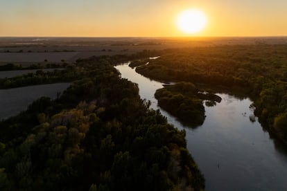
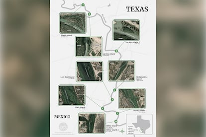
Since the start of Donald Trump’s second term, border security and stopping illegal immigration have become two of the main pillars of his administration. Based on those principles, and acting unilaterally, the Texas government has announced it has taken control of nine islands located in the water border between Mexico and the United States, along its territory between Laredo and McAllen. In a statement on Tuesday, Dawn Buckingham, that state’s land commissioner, authorized the Texas National Guard to access those small river islands in order to maintain the operational security of the southern border. The Mexican government has responded by asking that the 1970 Boundary Treaty between the two countries be respected and says that determination of the international boundary is the sole responsibility of the International Boundary and Water Commission.
Buckingham wrote in an official letter on October 26 to Major General Thomas Suelzer, commander and executive head of the Texas Military Department, and to Colonel Freeman Martin, director of the Texas Department of Public Safety. The letter says that after receiving a request from U.S. Customs and Border Protection regarding 28 islands in the Rio Grande that had previously been considered unclaimed or of undetermined ownership, the Texas General Land Office (GLO) determined it could access the islands, clear them and patrol them.
A spokesperson told this newspaper that the GLO used various sources to determine ownership of the islands, including historical maps, topographic surveys, aerial photographs and other geographic records.
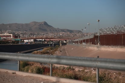
Mexico’s Foreign Ministry told EL PAÍS that the 1970 Boundary Treaty between Mexico and the United States establishes that the border follows the middle of the river’s normal channel. Therefore, island ownership can vary due to natural shifts in the channel, and it is solely up to the International Boundary and Water Commission (IBWC) to determine the international boundary. “Accordingly, any work or action intended to be carried out on these islands requires consideration and approval by both sections of that Commission in accordance with Article IV of the Treaty,” the ministry said.
This newspaper tried to contact the IBWC, both its Mexican and U.S. sections, but had received no response by the time this article was published. The Boundary Treaty was signed on November 23, 1970 to resolve border disputes, restore the Rio Grande’s role as a border, and regulate future changes in the river basin’s channels.
The GLO commissioner’s argument, according to the letter, is that “this effort builds on the GLO’s work to establish ownership of Rio Grande islands and ensure law enforcement can access state-owned property. While we have not confirmed criminal activity on these additional islands, past experience has shown how border islands can be exploited by cartels and smugglers,” a passage of the document says.
According to the same GLO spokesperson, agreements set out how the border is determined, including its relationship to the river channel. “For years, title to these islands had not been definitively established, creating uncertainty about whether they belonged to the state of Texas or the federal government or Mexico, and hampering access by state law enforcement and border security operations,” the agency replied to the request sent by EL PAÍS.
Rosario Sánchez, director of the nonprofit Binational Waters — an organization of scientists and water experts dedicated to improving the resilience of this resource across the Mexico–U.S. border region — says decisions about federal boundaries and waters “are not a state matter or decision.” She reiterates that the IBWC is the only body that can decide whether islands or the river channel have shifted due to natural conditions such as erosion, sedimentation or flooding, and whether that constitutes a change to the boundary.
Gabriel Eckstein, a water law scholar at Texas A&M University, says the real question is not whether they are taking islands that belong to Mexico but rather: “Are they claiming U.S. islands? That is, do they belong to the federal government or to the state of Texas?”
Eckstein, who is also president of the International Water Law Association, explains that if an island was part of Texas when it became a state in 1845 and remained U.S. territory according to the 1970 treaty, it could be argued that it is state property. But if an island was ceded by Mexico to the U.S. under the 1970 treaty, then it belongs to the federal government north of the Rio Grande.
However, the scholar notes that Texas’s claim that the islands had no owner is incorrect, since the boundary and title were already established by international treaties. “Texas contends that these islands are being used by cartels, which complicates the situation, because it is trying to assert its authority over concerns related to illegal immigration and drug trafficking,” Eckstein said by video call.
In 2023, the Texas General Land Office declared Fronton Island — a 170-acre island in Starr County — to be state land. After that declaration, the Department of Public Safety and the National Guard removed vegetation during operation Flat Top, which helped disrupt criminal activity there. For now, the decision is on the IBWC’s agenda.
Sign up for our weekly newsletter to get more English-language news coverage from EL PAÍS USA Edition