Drought helps expose the secrets of a Roman city
Archaeologists have taken advantage of the lack of rain in Spain to reconstruct the framework of Augustobriga, an ancient hub which was flooded seven decades ago when a reservoir burst
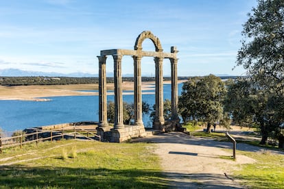

In a report from December 2021, Spain’s Ministry of Ecological Transition noted that 45% of national territory was under some level of emergency environmental alert due to the risk of droughts. However, this serious water shortage ended up becoming a great opportunity for archaeologists.
Bohonal de Ibor is a municipality located in the Spanish province of Cáceres. Nearby, the Valdecañas reservoir has been experiencing years of historically low water levels. Because of this situation, it was possible – for the first time ever – to use 21st-century technology to examine the remains of the Roman city of Augustobriga, which has been covered by swamp water since the reservoir burst back in 1957.
Today, Spain’s National Museum of Roman Art has published Augostobriga, a booklet that recreates the appearance of the walled city, which expanded 55 acres. Researchers have managed to document three necropolises, several temples, funerary inscriptions, ancient water storage tanks and other fascinating finds.
Classical texts point to Augustobriga as a Roman urban center along the road between today’s Mérida and Zaragoza. Named after Emperor Augustus, it also included the root briga – a common suffix in other Roman settlements in Hispania (the Roman name for the Iberian Peninsula).
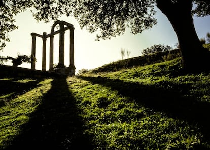
Since the 16th century, various scholars have been interested in the ruins of the ancient city. However, for hundreds of years, no one knew the settlement’s name, until an epigraph was discovered in the 19th century. In 1931, two of its great temples –Los Mármoles and La Cilla – were declared to be national heritage sites by the Spanish government. Both stood in what was known as the “forum” – the most prestigious part of the city.
The construction of the reservoir at the end of the 1950s made it necessary to shift the temples to higher ground, so that they would not be destroyed by water. Ultimately, 18,000 acres ended up being flooded in the province, on purpose or by accident.
In 2019 – during one of the most marked drops in the reservoir’s water levels – some vestiges of Augustobriga were once again made visible. Around this time, the General Directorate of Cultural Heritage and Fine Arts at the Spanish Ministry of Culture formed a working group with the provincial authorities. By 2021, researchers began conducting photogrammetric flights and a survey of the surface.
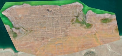
The archaeologists who conducted the study reveal that Augostobriga’s 55 acres were walled-in. The fortified enclosure ran parallel to the Tagus River, tracing an almost semicircular route. It was built out of granite and joined with lime mortar. In some areas, square towers were erected.
The authors of the study explain that the city had “at least three entrances: south, east and west. Within the city – according to our data – the blocks configured a regular orthogonal pattern. It had three major streets – each about 20-feet wide – parallel to each other and to the Tagus.” There were other smaller streets running in a north-south direction – a sewage system ran beneath them, receiving water from the communal baths.
The forum was located in the center of the semicircle formed by the wall, on the edge of a ravine. The aforementioned temples of Los Mármoles and La Cilla were located there.
“La Cilla occupied the center of the plaza, while Los Mármoles was diverted to the northwest. This suggests that there was another temple nearby, a second twin temple to the west,” the archaeologists assert.
They have also detected a platform of granite blocks next to a possible pond or cistern.
“The mass of [Roman concrete] has been overturned and dragged… it could be the remains of another temple, totally razed to the ground.”
In addition to the temples, experts have documented other possible buildings of a public nature. To the southeast of the forum, “a new square seems to be visible – albeit of smaller dimensions – and to the northeast, some public baths.” In future reports, the archaeologists expect to confirm “possible buildings constructed to host shows.”
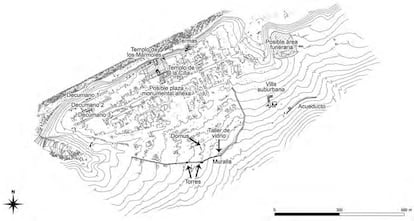
Outside the walled space, a villa and an aqueduct for the water supply have also been located. With all of this data, a city plan has been drawn up.
The specialists conclude in their report that, in the future, it will be necessary “to carry out other excavations at the site, aimed at evaluating the state of conservation [of the city], as well as carrying out geophysical surveys that provide information regarding certain urban structures.” With an entire Roman city having emerged from the water, there is a lot of work to be done.
Sign up for our weekly newsletter to get more English-language news coverage from EL PAÍS USA Edition
Tu suscripción se está usando en otro dispositivo
¿Quieres añadir otro usuario a tu suscripción?
Si continúas leyendo en este dispositivo, no se podrá leer en el otro.
FlechaTu suscripción se está usando en otro dispositivo y solo puedes acceder a EL PAÍS desde un dispositivo a la vez.
Si quieres compartir tu cuenta, cambia tu suscripción a la modalidad Premium, así podrás añadir otro usuario. Cada uno accederá con su propia cuenta de email, lo que os permitirá personalizar vuestra experiencia en EL PAÍS.
¿Tienes una suscripción de empresa? Accede aquí para contratar más cuentas.
En el caso de no saber quién está usando tu cuenta, te recomendamos cambiar tu contraseña aquí.
Si decides continuar compartiendo tu cuenta, este mensaje se mostrará en tu dispositivo y en el de la otra persona que está usando tu cuenta de forma indefinida, afectando a tu experiencia de lectura. Puedes consultar aquí los términos y condiciones de la suscripción digital.


