Spanish researchers discover possible location of legendary temple of Hercules Gaditanus
Experts from Seville University may have solved one of the holy grails of archaeology thanks to digital terrain modeling, which has identified a monumental structure in the Bay of Cádiz

The legendary temple of Hercules Gaditanus, who was known as Melqart in Phoenician times, was a key pilgrimage site in ancient times. According to classical records, the temple witnessed the passage of historical figures such as Julius Caesar and the Carthaginian conqueror Hannibal, and dated at least as far back as the ninth century BC.
But thousands of years later, its location remains a mystery, and finding the temple has become something of a holy grail for historians and archeologists, who have been searching for it for centuries.
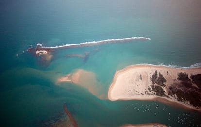
Now there is a possible answer to this great mystery. Ricardo Belizón, a Ph.D. student at Seville University in southern Spain, has come up with a new hypothesis, which is backed by scientists from his university and the Andalusian Institute of Historical Heritage (IAPH). Thanks to free software and digital terrain modeling, Belizón has identified traces of a monumental building in the Caño de Sancti Petri, a shallow channel in the Bay of Cádiz, between the towns of Chiclana de Frontera and San Fernando, in the southern region of Andalusia.
“Who knows how far the land extended into the sea on the south side and how much of this land must have been sea, particularly in what is now considered marshland?” This question was raised in 1794 by historian and traveler Antonio Ponz, when he contemplated those labyrinths of sea and land that make up the Bay of Cádiz. And it was exactly this question that Belizón set out to answer when investigating what the coastal landscape of Cádiz was like in ancient times in his doctoral thesis. But he was not expecting his research to take such a surprising turn.
“We researchers are very reluctant to turn archaeology into a spectacle, but in this case, we are faced with some spectacular findings. They are of great significance,” said Francisco José García, the director of the department of Prehistory and Archaeology at Seville University, during the recent presentation of the research at the Cádiz Center for Underwater Archaeology.
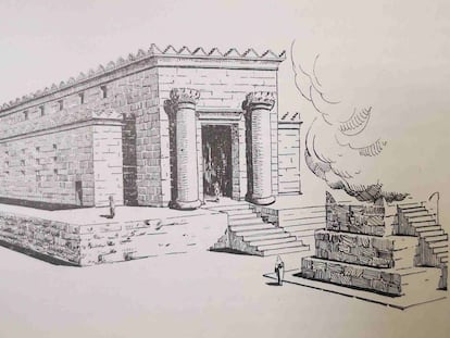
The temple of Hercules Gaditanus is mentioned in classical Greek and Latin literature as the place where Julius Caesar wept bitterly before a representation of Alexander the Great and where the Carthaginian conqueror Hannibal went to offer thanks for the success of his military campaign a century and a half earlier. All these references mention “a changing environment, in contact with the sea, subject to the changing tides, in a temple where there must have been port structures and a seafaring environment,” says Milagros Alzaga, head of the Center for Underwater Archaeology (CAS), who also participated in the research.
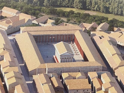
Following decades of academic controversy and different proposals for the temple’s location, the one put forward now by Seville University and the IAPH falls within a radius earmarked as the most obvious. The site is a huge marshy channel dominated by an islet and the castle of Sancti Petri, which rises above it. For more than two centuries, the area has been yielding important archaeological finds, now on show in the Museum of Cádiz, such as large marble and bronze sculptures of Roman emperors and various statuettes from the Phoenician period. All these discoveries helped to delineate the location of the temple of Hercules Gaditanus as lying somewhere between the slopes of the islet itself and a slither of fine sand and a rocky intertidal zone, known as Boquerón point.
More fieldwork needed
The exact area has been defined thanks to technology known as Digital Terrain Model (DTM) which was provided by the National Geographic Institute and the Navy Oceanographic Institute. “We have worked with public data, with digital terrain modeling and with free software,” says Belizón. The objective was to trace the paleo-landscape from 3,000 years ago in an area that has been exposed to sea variations, erosion from storms and catastrophic weather episodes, such as tidal waves. The researcher discovered several aberrations in the terrain that revealed “a totally anthropized coastline, with a large building [the possible temple], several breakwaters, moorings and an inner harbor.”
Measuring 300 by 150 meters – like the island on which it stood – the rectangular structure lies between five and three meters underwater and seems to fit with descriptions in the classics that describe both the location of the temple and its definition as a great Phoenician monument. According to the classics, this complex was accessed through two columns, with a frontispiece that depicted the Labors of Hercules, within which there was an eternally burning flame. The sacred area was separated from the current Boquerón point by a canal and was accessible to Phoenician, Punic and Roman ships, becoming famous for the large number of supposed relics it housed from the ancient world.

The digital work was contrasted with some initial investigations at low tide when it has been possible to document traces of important ashlars and even ceramic remains. Although the investigation has been underway for almost two years, much more archaeological fieldwork will be necessary to confirm or reject what, for now, is a hypothesis, albeit an advanced one. “These are areas that are difficult to work in and have poor visibility,” says Alzaga.
The modeling of the ancient Cádiz coastline has not only revealed the possible temple of Melqart, but also an inner harbor or dock south of the temple, which was a flood zone until less than two centuries ago, and an important settling along the coast with various buildings mainly from the Roman period yet to be defined. Altogether, it covers a large space – larger than the entire excavated area of the Roman city of Baelo Claudia in Tarifa. “It is larger than the surface of Gades and its size could change the idea we’ve had until now of what the bay was like,” says Antonio Sáez Romero, a professor from the department of Prehistory and Archaeology, who also took part in the research.
The new hypothesis of the location of the temple fits with various findings and proposals made throughout the 20th century, but also differs from others, the last of which was The location of the sanctuary of Melqart in Gadir: contribution of the PNOA-LiDAR data, by Antonio Monterroso-Checa, professor in the Archaeology department at Córdoba University. Monterroso-Checa rejected the possibility that the temple was in Sancti Petri due to orographic changes and the lack of new evidence, suggesting instead that the monument had been built on the Martyrs of San Fernando hill, which was also formerly an island. Further research will definitively clear up the mystery that Ponz flagged up more than two centuries ago. “With these kinds of exceptional findings, we can get ahead of ourselves. We want to be very cautious. They are very interesting and hopeful, but it is now that the most exciting part begins,” says Sáez.