Hurricane Beryl thinks we are in September
The May and June indicators are atypical for this season, and global warming has a lot to do with it. Studies suggest that the next tropical hurricanes will be more intense than in previous years

Scientists are among the few who have not been surprised by the intensity and precocity of Hurricane Beryl. This storm became a hurricane on June 30; 42 days earlier than the average of previous years, and reached the highest category of the Saffir-Simpson scale in less than 45 hours. It thus becomes the first hurricane of the 2024 Atlantic season and the fastest hurricane to reach Category 5 intensity in the last century. Kerry Emanuel, meteorologist and professor emeritus of Atmospheric Sciences at the Massachusetts Institute of Technology (MIT) is one of the experts who was not surprised by Beryl: for decades he has been warning that these climatic events would increase in severity as a consequence of global warming. According to Emanuel, Beryl is a preview of what is to come: “This confirms that the predictions we made years ago are correct.”
For decades, the scientific community has correlated rising sea temperatures with more and more intense hurricanes. For hurricanes to form, the ocean temperature has to reach 26°C (80ºF). The Atlantic reached that temperature in May, even though it is typically recorded from September onwards. The La Niña phenomenon and carbon dioxide and aerosol emissions (induced by humans) are the main reasons why Beryl thinks that we are in September. “We are witnessing an extremely atypical moment,” says Rodney Martinez, representative of the World Meteorological Organization (WMO) for North America, Central America and the Caribbean. UNICEF warns that more than 3 million children are at risk from the hurricane.
Recently, the U.S. National Oceanic and Atmospheric Administration (NOAA) predicted an “above normal” tropical hurricane season. The NOAA forecast that between 17 and 25 storms will be powerful enough to be named, of which between eight and 13 are forecast to become hurricanes, and four and seven to be major hurricanes. In other words, they will be Category 3 or higher, with winds of 111 mph or higher, and waves 3.6 meters high. If this forecast is correct, this would be almost double the number of hurricanes than the average of previous years.
Rodney Martínez is concerned about the forecast. “This is unprecedented. Sea temperatures have been breaking records for 14 months,” he explains by phone. The trend now, he explains, is for these record highs to continue. “We already saw what happened with Otis, and we are seeing something even more intense now. It doesn’t seem like the situation is going to be reversed.”
Although some scientists — and especially politicians — are more cautious when it comes to directly blaming climate change, both Emanuel and Martínez are clear about the connection. “It is a problem of the present, not of the future,” says the MIT researcher. They are not the only ones. A study from October 2022 argues that 10% of the rain that Hurricane Ian dropped on Florida was due to the climate crisis. And the WMO — which belongs to the United Nations — recognized that global warming will lead to an increasing percentage of powerful hurricanes. “Climate science is increasingly able to show that many of the extreme weather events that we are experiencing have become more likely and more intense due to human-induced climate change,” warned WMO Secretary-General Petteri Taalas in mid-2022.
Although the climate crisis affects the entire planet, the effects are not felt equally. The Atlantic tends to warm more easily. Although this difference is less than a degree, it has a huge impact since wind and sea temperatures are what drives hurricanes. That is why in this transition season between the El Niño and La Niña phenomena, in which high-altitude winds are reduced, there is nothing stopping this type of storm. “All the ingredients are coming together for the intensity to increase,” Martínez explains.
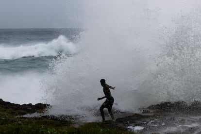
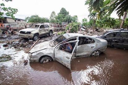
Fallen trees, flooded streets, torn off roofs, floating cars and completely crushed boats. These are some of the images left in its wake by Hurricane Beryl, which was the first Category 5 storm to hit the small Caribbean islands, leaving at least seven dead. “We know that these events leave islands that had no experience with these intensities with almost no capacity to respond,” says Martinez.
Only two hurricanes have made landfall in Jamaica in the last 40 years: Sandy in 2012 and Gilbert in 1988. No hurricane as strong as Beryl has even come close to the coast of Jamaica since Category 4 Dean hit the south of the country in 2007.
Advance early warning systems
The increasing intensity of hurricanes and the inability of forecasting more than three or four days in advance make the task of preparing the population and sending evacuation alerts very difficult. The digital divides (with more than 60% of rural areas in Latin America without internet) and the difficulty of accessing certain territories mean that early warnings do not always reach the people in time.
That’s why both NOAA and WMO are working on new forecast models that will help assess the likelihood of rapid intensification and more inclusive warning systems. “A tremendous amount of progress has been made, but we’re still not getting to the last mile of the territory,” says Martinez. Urgent progress is needed in Latin America, the world’s most disaster-prone region. Some 1.9 million people — including half a million children — have been affected by a disaster in the Caribbean alone.
The agencies offer similar recommendations to the affected populations: charge cell phones, take shelter in a safe place away from the coast, keep bottles of water nearby and be very attentive to information from local authorities. Although some citizens are familiar with these hurricanes, authorities warn against underestimating the situation.
Emanuel points out this is not a problem for tomorrow, but one that is having an impact today, and calls for more conversation on climate migration: “It has become fashionable to live on the coasts and governments are practically subsidizing it. Relocating all the populations that are exposed to this type of circumstances is going to cost a fortune. Guaranteeing that right is what really worries me.”
Sign up for our weekly newsletter to get more English-language news coverage from EL PAÍS USA Edition


