The Atlantic hurricane season has begun, and experts warn it will be more active than normal
High ocean temperatures and the evolution of La Niña could generate between eight and 13 such weather events, compared to the average seven


Hurricane Otis left a scar on Mexico. Besides producing economic losses to the tune of US$15 billion — making it the costliest weather event of 2023 — it also turned out to be an almost unprecedented phenomenon. In just 12 hours, Otis went from a tropical storm to a Category 5 hurricane, the highest possible classification, suggesting that hurricane and storm dynamics may be changing.
This 2024 Atlantic hurricane season could also yield other indicators. According to predictions by the U.S. National Oceanic and Atmospheric Administration (NOAA), there will be “above normal” activity.
NOAA is warning that there is an 85% probability of more name-worthy storms during a season that runs from June 1 through November 30 than the average year. Between 17 and 25 named storms are expected, of which eight to 13 could evolve into hurricanes and four to seven could be classified above Category 3.
Bernadette Woods Placky, chief meteorologist at Climate Central, a nonprofit news organization that focuses on climate science, explained at a news conference that the annual average is 14 storms for the first category, seven for the second and three for the third. “These are predictions about storms in general, without knowing yet if they will reach land,” she clarified, adding that, so far, it is impossible to indicate what their trajectory will be or if they will reach the coast.
According to Katharine Hayhoe, chief scientist at The Nature Conservancy, certain elements are emerging in the Atlantic to generate the perfect storm. Adding to the evolving conditions of La Niña in the Pacific — which should become official later this year — are near-record Atlantic Ocean temperatures and reduced trade winds. “Storms capture their energy from the ocean, so a high temperature increases the likelihood of a storm becoming a hurricane,” says Hayhoe. And although there is still no certainty that climate change is generating a greater number of hurricanes, Hayhoe points out that it is having a negative impact in several respects.
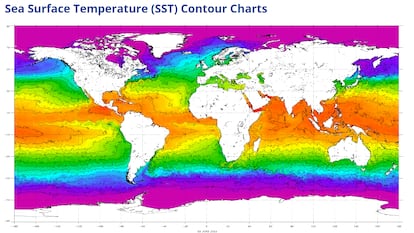
“Climate change is making hurricanes worse in multiple ways,” says Hayhoe, adding that they intensify faster, become stronger and last longer on land, as well as appearing to produce a lot more rainfall. “We have to remember that the ocean absorbs up to 90% of the heat that is released by climate change generated by human activities,” she says. So, the fact that the Atlantic had high temperatures just before the start of hurricane season is not good news.
In order for hurricanes to occur, sea surface temperatures must reach around 27 °C (81 °F). And by May 2024, even before the start of hurricane season, the surface waters in the Atlantic tropical belt were recording warmer temperatures than any other month of May. In the same month in the Caribbean, waters were already reaching a weekly average of 28°C (82.4ºF), a temperature unusual before August.
According to experts, this does not mean that the season will be worse in the Caribbean or that all storms will reach the mainland, so there is really no way to predict whether it will be a catastrophic season in terms of the potential damage. What is certain is that there is enough information for countries to prepare for the worst. NOAA, for example, announced that the National Hurricane Center has created a system to translate its texts into Spanish and thus reach more people, although its scope only extends as far as the U.S..
Woods recommends keeping alert to the early warnings put out by the meteorological services in each country and maintaining clear evacuation routes. Storm Otis made one thing clear: storms can intensify faster than expected and, in the face of this, the emergency is greater. “It changes everything, because you can’t get people out in the same amount of time,” Woods concluded.
Sign up for our weekly newsletter to get more English-language news coverage from EL PAÍS USA Edition


