Extreme weather in the US: heavy snow and record heat at the same time
The National Weather Service warns of “life-threatening” conditions due to a brutal winter storm across the Midwest and North
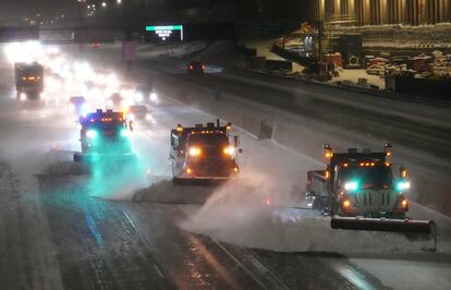

The United States braces for a battle of extreme weather this week. A “historic” winter storm slammed most of the western and northern US on Wednesday, bringing blizzard-like conditions, including frigid cold, heavy snow and strong winds. The brutal storm will continue to plow much of the country during the next two days, resulting in “life-threatening” conditions, according to the National Weather Service (NWS). Officials are urging residents to stay home. Meanwhile, some eastern and southeastern states are expected to see record high temperatures, in some cases 30 to 40 degrees Fahrenheit above normal.
The massive winter storm in the west and north shut down roadways and forced schools and businesses to close. Many schools throughout the Dakotas, Minnesota and Wisconsin were called off for Wednesday. In Minnesota, the State Legislature closed. In Wyoming, virtually every road was impacted by the storm, and many were completely closed off. Officials warned they may stay that way for days. As of Wednesday afternoon, more than 1,500 flights in and out of the US had been canceled and thousands more were delayed, according to the flight tracking service FlightAware. “Significant travel impacts are likely through Thursday due to falling and blowing snow,” warned the NWS. “The worst conditions will be late Wednesday into Thursday. Please avoid travel unless absolutely necessary.”
On Wednesday, over 44 million Americans from California to Wisconsin were under warnings for significant accumulation of snow and ice as well as strong winds. A blizzard warning was issued for both the Dakotas, Minnesota, and Wyoming due to the combination of heavy snow and strong winds. The heaviest amounts of snow are expected across east-central Minnesota and west-central Wisconsin, the weather service said. This region will get anywhere between eight and 17 inches (20 to 43 centimeters) of snow between Wednesday and Thursday, in addition to the snow that fell prior to the storm. The Minneapolis-St. Paul metropolitan area in Minnesota could get 20 inches (50 centimeters) of snow or more for the first time in over 30 years.
The winter storm will make its way toward the East Coast later in the week, bringing snow to Upstate New York and New England. Some northeastern states may also get dangerous amounts of ice. Power outages are also expected.
As the northern US deals with the winter blast, many locations in the East and South will see record heat between Wednesday and Thursday. Some areas may even get temperatures 30 to 40 degrees Fahrenheit above normal for this time of year. “These highs on Thursday will be particularly anomalous for the Ohio Valley and Mid-Atlantic, where temperatures 40 or more degrees above average will feel more like June than February”, noted the weather service. Washington, D.C., could hit 80 F on Thursday, which would top the record of 78 F set in 1874.
Sign up for our weekly newsletter to get more English-language news coverage from EL PAÍS USA Edition
Tu suscripción se está usando en otro dispositivo
¿Quieres añadir otro usuario a tu suscripción?
Si continúas leyendo en este dispositivo, no se podrá leer en el otro.
FlechaTu suscripción se está usando en otro dispositivo y solo puedes acceder a EL PAÍS desde un dispositivo a la vez.
Si quieres compartir tu cuenta, cambia tu suscripción a la modalidad Premium, así podrás añadir otro usuario. Cada uno accederá con su propia cuenta de email, lo que os permitirá personalizar vuestra experiencia en EL PAÍS.
¿Tienes una suscripción de empresa? Accede aquí para contratar más cuentas.
En el caso de no saber quién está usando tu cuenta, te recomendamos cambiar tu contraseña aquí.
Si decides continuar compartiendo tu cuenta, este mensaje se mostrará en tu dispositivo y en el de la otra persona que está usando tu cuenta de forma indefinida, afectando a tu experiencia de lectura. Puedes consultar aquí los términos y condiciones de la suscripción digital.


