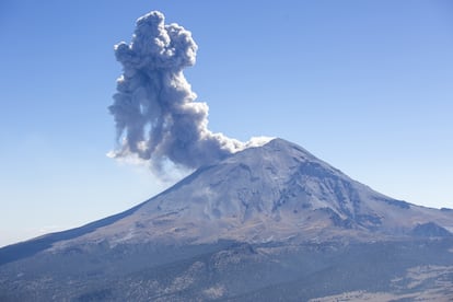
UNAM achieves a 3D model of Mexico’s Popocatépetl volcano with the help of AI
The project’s goal is to understand the peak’s internal structure, resolve questions as to the existence of magma chambers and optimize monitoring and disaster prevention


Scientists from the National Autonomous University of Mexico (UNAM) have created the first tridimensional model of the Popocatépetl volcano in the pursuit of understanding its internal structure, resolving doubts as to the existence of magma chambers, and optimizing monitoring efforts as well as disaster prevention, according to a recent issue of the Gaceta UNAM, the university’s bi-weekly publication. The study Estructura de velocidades sísmicas del volcán Popocatépetl, México, a partir de campos difusivos (Structure of seismic velocities of the Popocatépetl volcano, Mexico, via diffusion fields), which was published in the journal ScienceDirect, states that the model will better allow for the anticipation of future eruptive episodes. “What we do, literally, is generate a radiography of its interior, only it’s three-dimensional. This represents an advantage because it allows us to turn ‘Popo’ around and observe how seismic waves propagate within it,” explains Marco Calò, lead researcher of the Geophysics Institute project. One of the innovations presented by the illustration, which makes use of artificial intelligence, is the possibility of constructing tomographies in four dimensions in the future.
Since 1994, the year that Popocatépetl erupted for the first time in more than 70 years, various geophysics studies have been carried out in the hopes of understanding the eruptive history, activity and volcanic perils of the peak also known as “Don Goyo.” But previous models based on volcanic-tectonic seismicity have not been sufficient in describing patterns in certain areas or across a large range of depth, due to spatial distribution of seismic activity and stations that have been used, according to the report. “In this work, we propose the first 3D velocity model of Popocatépetl volcano describing the whole edifice,” states its text.
Project leaders utilize 18 seismic stations located across the volcano. They installed eight of them, and the rest belong to the National Center for Disaster Prevention. Teams register at least 100 measurements per second and that data, an immense quantity of information, is automatically processed using AI.
“Previously, everything was analyzed manually. Today, with AI, we can process a year’s worth of data, from all stations, in three hours,” says Karina Bernal, a post-graduate Earth sciences student at UNAM who participated in the project. Bernal says the human component is key to the study, despite the support provided by AI in facilitating the processes. “Specialists train the model, validate the results and interpret what is observed,” she says.
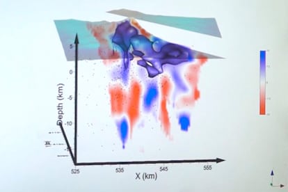
The 18-station study allows for the detection of interconnected internal structures as possible regions of magma accumulation and ascending conduits and abnormalities. All are identified by seismic waves traveling through the subsoil, which are faster in hard rocks and slower in areas with magma or soft material.
The study suggests the presence of a mushroom-shaped magmatic system in two regions with high Vs (S-wave velocity, a rapid change in wind speed or direction over a short distance) between zero and five kilometers (approximately three miles) above sea level, and four and seven kilometers (2.4 and 4.4 miles) below sea level, connected by a narrow tube-shaped conduit.
According to the study, the most shallow high Vs region is directly related to old and new volcanic structures, as a result of magmatic materials mixing with and being affected by an intense process of degasification, which increases magma’s viscosity and crystal content.
The deepest region of high Vs is interpreted as magmatic material trapped by lithostatic pressure exerted by the weight of overlying rocks and sediments on a deep rock formation. In addition, the model presents evidence of buried volcanic paleostructures and remnants of ancient volcanic collapses.
At 4 a.m., the Institute of Geophysics team sets out for Amecameca, in the State of Mexico. From there, their route continues towards Iztaccíhuatl Popocatépetl National Park, located on the border of the states of Puebla, Morelos and the State of Mexico. Between their starting point in Mexico City and their destination are some 56 miles, the last 12 of which are traversed on foot at an altitude of more than 13,700 feet. “The expeditions are carried out in extreme conditions. Planning activities at high altitudes requires technical knowledge, physical preparation and complex logistics, because the idea is to work with as little risk as possible,” Calò said in the Gaceta.
Sign up for our weekly newsletter to get more English-language news coverage from EL PAÍS USA Edition


