Deep within a Spanish forest, an Iron Age settlement turns out to be a medieval fortress
Laser photography has revealed a site covering 25 acres with a long defensive wall. But the spot is under threat from a planned wind farm and power station

In Spain’s northwestern region of Galicia, archaeological sites from the pre-Roman period are usually referred to as “castro,” which conjures up images of a fortified settlement from the Iron Age. One example is Castro Valente, which stands on a hill straddling the municipalities of Padrón, in the province of A Coruña, and A Estrada, in the province of Pontevedra.
But now, two local archeologists, Mario Fernández-Pereiro and José Carlos Sánchez-Pardo of the University of Santiago de Compostela, have proven that Castro Valente was in fact something altogether different: it was a sprawling medieval fortress dating from the 5th to the 7th century of the current era. It had 30 towers and a wall spanning three-quarters of a mile; it covered a total area of 25 acres. According to their study, Searching for an early medieval castle in the vegetation, the towers were covered by roofs, in a style similar to the Roman walls of Lugo, built in the 3rd century to defend the town of Lucus and which have been a World Heritage Site since 2000.
However, the remains of the newly rediscovered fortress have been heavily damaged by reforestation and fire trails. In addition, the remains of the fortress are now under additional threat by the impending installation of four wind turbines, six electrical towers and an electrical substation.
The first thing that caught the attention of the researchers was the name that locals use for the mountain that holds the archeological remains: A Cerca, which in the Galician language means “the enclosure.” This seemed to suggest the possible “monumentality of the defensive system and, on the other hand, that the existence of this enclosure had not gone unnoticed by the surrounding rural communities.”
There are no documents from the Middle Ages or the Modern Age that attest to the existence of the fortress. In fact, it was not until the end of the 19th century and the early 20th century when there were the “first written mentions… [of] Castro Valente” in books and newspapers, but it was always referred to as a structure from the Iron Age (between 1500 and 500 BC).
In 1865, the archaeologist and historian Manuel Murguía, while writing about the history of Galicia, described the fortress as being in a good state of conservation. “About a league northeast of Iria (modern-day Padrón) there is a formidable castro – Castro Valente – which still retains part of the wall that surrounded it.”
In 1913, a weekly periodical mentioned it again, detailing “the entryways, the visual control and the defensive system.” The castle was also cataloged by the Archaeology Service of the Council of Galicia. However, there is little more information available on the structure.
Castro Valente is located on a 1,300-foot-high hillock. Despite not being the highest in the area, it’s very recognizable, as it’s a solitary hill with no nearby elevation. The Ulloa river embraces its north face. The summit is flat and resembles the shape of a kidney. Experts are convinced that it was flattened to build the fortress.
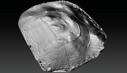
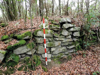
According to the result of LIDAR laser photography, the enclosure covers about 25 acres of land. Through this photographic technology, the walls are perfectly distinguishable despite being covered with thick vegetation. Surveys on the ground have determined that the wall was built with double-leaf masonry construction, and its interior filled with earth and gravel, thus forming a wall with a thickness that varies between eight to 14 feet.
This monumental defense that surrounds the site is three-quarters of a mile long, and was once crowned by 30 towers. In the superficial inspection carried out by the experts, they have located at least six towers with complete certainty, and a seventh that was almost completely destroyed when a fire trail was opened up through it.
The archaeologists also complain that the state of conservation and the dense vegetation – which includes pines and acacias – makes it very difficult to identify the structures. “[It’s] only possible to locate and document… the main access to the place, which is found in the southwestern sector of the fortified settlement.”
Two other less relevant entryways are located in opposite places in the enclosure. The first – located thanks to aerial remote sensing – lies north. The second seems to be located to the southeast, in an area heavily affected by a fire trail. It is identifiable due to the existence of a possible tower that would have defended this access.
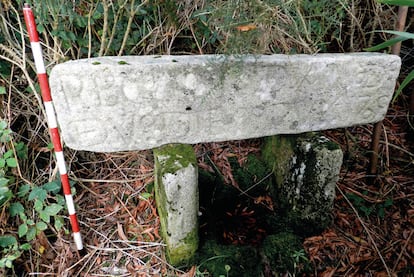
In the interior space of the enclosure, the experts believe they have located the “possible existence of constructions with perishable materials and stone. In the vicinity of the deposit, there are several important water sources, the closest being the one known as Fonte do Santo or Fonte de San Xoán, located in the southern area. Near this specific water source, there’s a carved stone with an inscription related to an old chapel: ‘A hermitage on top of the mountain dedicated to San Juan de Castro Valente, where, they say, there was great devotion and crowds for many years,’” is how the archeologist Murguía interpreted it, in the 19th century. This chapel was moved at an unknown time to the foot of the hill on the southern slope.
During the excavation of the site, evidence of bricks and tiles from the Roman era have been found, along with small fragments of red-paste ceramics. All this material has appeared fragmented and close to the surface, especially in the damaged areas near the fire trails.
To date, three archaeological surveys have been carried out in the northwest zone, two on the wall and a third on a 315-square-foot space within the enclosure. “The results have allowed us to document the construction technique of the defensive system and locate a possible wall-like structure belonging to an intramural building. In the survey carried out in one of the [towers], a large number of fragments of [tiles] was recorded, which makes us think that this tower could have been covered by these pieces of Roman tradition,” the report states.
Despite the brevity of the archaeological excavation, much valuable data has been obtained, including some information that may help determine “the construction technique [used to build] the defensive system of the walled enclosure.” The archeologists note that the northwestern portion of the site is preserved “in very good condition.”
Within the walls of the site, there are indications of an interior stone building, although “it’s not yet possible to clarify its functionality or the characteristics of the structure to which it belongs,” the archaeologists note. Finally, movable material of “low quantity and quality, which could indicate a time near the end of the Roman Empire until the middle of the High Middle Ages (5th-7th centuries)” has been found.
“[These] are only the first and exciting steps to determine the true nature of this unique fortified enclosure,” the report concludes.
Sign up for our weekly newsletter to get more English-language news coverage from EL PAÍS USA Edition


