Archaeologists find previously unknown Roman city at the foot of the Pyrenees
Dated between the 1st and 2nd centuries, the urban complex had ‘buildings of enormous proportions’ and public services including baths, water supply, streets and sewers

In 2018, the City Council of Artieda—located in northeastern Spain in the province of Zaragoza, and part of the country’s Aragon region—asked the University of Zaragoza’s Archaeology Department for help in studying some ruins located around the San Pedro hermitage, known variously as El Forau de la Tuta, Campo de la Virgen, or Campo del Royo. Three years later, the experts have confirmed that these sites formed a large single archaeological complex, and they detected two phases of occupation on the surface of the site: one during the imperial Roman period (the 1st to 5th centuries) and another during the early-medieval Christian era (the 9th to 13th centuries). Now, the research team has published the results in a report, El Forau de la Tuta: A Hitherto Unknown Roman Imperial City on the Southern Slopes of the Pyrenees. It is striking that, despite the city’s large dimensions and “buildings of monumental proportions,” no one knows its ancient name.
The study was authored by the experts José Ángel Asensio, Paula Uribe, Lara Íñiguez, María Ángeles Magallón, Milagros Navarro, Jorge Angás, Enrique Ariño, Irene Mañas, Carmen Guiral, Cristian Concha, Óscar Lanzas, Aurora Asín, and Guillermo Mora. The report notes that based on important evidence from the ruins preserved in the hermitage, as well as artifacts held in various public and private collections and the findings at the site, the settlement was “of urban character—the city’s name is currently unknown—and it developed during the [Roman] imperial period. Later, the same site took on another iteration as a rural habitat during the Visigoth and early Andalusian periods.”
The specialists have also found that, between the 9th and 13th centuries, another peasant habitat-type town or village was superimposed on top of the Roman settlement. They have identified the village as Artede, Arteda, Artieda or Arteda Ciuitate. The medieval enclave’s ruins include the apse area of the church, which was part of the San Pedro hermitage; numerous silos with circular openings, which were excavated from the subsoil and only perceptible by geo-radar; and an extensive cemetery consistent with Christian burial rites (the Paleoymás company partially investigated the latter in 2020).
The El Forau de la Tuta site is located 1.5 kilometers from Artieda’s city center, on the fertile plain of the Aragón River. It is situated inside an agricultural plot about 390 meters long and 140 meters wide. It occupies an area of four hectares, but it is possible that the site’s dimensions are even larger and that it extends to other—still unexplored—agricultural lands.
The French Route
The Roman settlement stood next to the road connecting three northern cities: Iaca (Jaca, Huesca), Ilumberri (Lumbier, Navarra) and Pompelo (Pamplona, Navarra). Currently known as Camino Real de Ruesta a Mianos (the High Road from Ruesta to Mianos), the road lasted through the Middle Ages as a stretch of the French Route, the Arles Way or the Via Tolosana (Tolouse Route), as part of the Way of St. James (Camino de Santiago), which leads to Santiago de Compostela in Spain’s northwestern Galicia region, where the remains of Saint James were said to be buried.
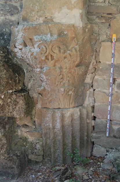
Inside the hermitage, the study’s authors have identified two Corinthian capitals, three Italic Attic bases, a classical Attic base, several flat-edged fluted shaft drums, and a fragment of cornice. The huge dimensions and typology of the artifacts indicate that they came from several early imperial public buildings. According to José Ángel Asensio, one of the investigation’s research directors, two of the capitals “would have been part of Corinthian columns more than six meters high, and they would have belonged to a public building of enormous dimensions, perhaps a forum temple. Regarding their chronology, stylistically they can be dated to the end of the first century, from the late Flavian period or the beginning of the Antonine period.”
The study confirms that these pieces come from at least two different monuments. Their typologies indicate that they were sculpted more than half a century apart, “which demonstrates a prolonged period in the process of monumentalizing the city.”
To the west of El Forau de la Tuta, next to the San Pedro ravine, “an impressive set of public works made of opus caementicium (the Romans’ early version of concrete) including at least four sewer outlets, a powerful massive abutment, a foundation, and a series of quadrangular structures,” possibly supply cisterns, is also preserved. The sewers are covered with barrel vaults and formwork that are supported by 0.80-meter-high side walls. “The presence of these works is typical of urban settlements, where water drainage was a problem that had to be addressed, especially in relation to buildings, such as bath houses, that produced a large amount of water waste.
This report by experts from the Instituto de Estudios Altoaragoneses [Institute for Early Aragon Studies], the universities of Zaragoza, Bordeaux, Madrid Polytechnic, Salamanca, UNED [National University of Distance Education] , and the Zaragoza School of Tourism also indicates the location of four tombstones from the site, which were held in Jaca’s Diocesan Museum and in private collections in Artieda. Analyzing their inscriptions, the archaeologists have concluded that the gravestones came from an “important cemetery that was maintained through the end of the period.” In addition, some of the names engraved on the tombstones are of Basque-Aquitaine origin, “which supports the presumed Basque ethno-linguistic affiliation of the inhabitants of this part of the Jacetania-Canal de Berdún region during Roman times.”
Archaeologists are also currently studying a sculptural fragment that is preserved in an Artieda private collection. The artifact—which was collected near the hermitage— is an incomplete, nearly life-sized left hand that holds a patera umbilicata [an offering bowl], which would have been part of a statue representing an offering figure. The limb was sculpted in white Luni (Carrara) marble, a material typically used in early-imperial urban settlements.
In the first round of excavations in 2021, the archaeologists confirmed the existence of an intersection of two roads. “On one of the roads, possibly one of the settlement’s main streets, we documented the ruins of a sidewalk and a surface channel for draining water, which pedestrians could circumvent by means of three steppingstones. Judging by the presence of the two square foundations on its sides, this main street must have had a porticoed sidewalk,” explains Asensio.
A building for baths
Similarly, in one of the excavations they performed, the archaeologists found ample remains of black and white mosaics made with tesserae (small cubes of stone or glass) and fragments of rudus (a layer of material placed under the tesserae), as well as pavement in the subsoil that belonged “to a rectangular space of about 5 by 3.50 meters, which preserved the entryway’s threshold, which was carved into two pieces of sandstone and housed a double swing door.” The experts associate this finding with a building for baths.
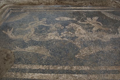
Inside this structure, under a large number of slabs that fell in the building’s collapse, archaeologists found a practically complete black-and-white tessellated pavement (with some isolated red and yellow tesserae); it was extraordinarily preserved. Decorated with iconographic motifs in white on a black background, it has shells or scallops in the four corners, while the central emblem features seahorses, ridden by little Cupids, facing each other next to three representations of marine animals, a fish in the upper part and possibly two dolphins in the lower part.
Thus, the archaeologists are certain that everything they’ve found so far “corresponds to a single urban complex from between the first and second centuries, and that the city had infrastructure and public monuments, including baths, a water supply system, regular urban planning, sewers, and possibly a temple. They admit to being surprised at not knowing the city’s name, but no historical document mentioning it has survived.


