Super Typhoon Mawar lashes Guam as Category 4 storm with strong winds and rain
Officials were bracing for ‘considerable damage’ including non-reinforced concrete walls being blown down, fuel storage tanks rupturing and overturned cars
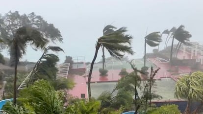
Super Typhoon Mawar barreled into Guam as a powerful Category 4 storm Wednesday, pummeling the U.S. Pacific territory with high winds, heavy rains and a dangerous storm surge that swamped low-lying areas as residents hunkered down in homes and shelters.
The typhoon’s center passed over the northern tip of Guam on Wednesday evening, the National Weather Service said. It is the strongest storm to hit the territory of over 150,000 people in decades.
Meteorologists suspect the storm clipped the far northern part of the island, but otherwise it was in the channel between Guam and its neighbor to the north, Rota, warning coordination meteorologist Landon Aydlett said by telephone. Peak winds at the weather service office in Guam reached 105 mph (169 kph), but it later lost its wind sensors, he said. The building was vibrating, with a “constant, low rumbling,” and doors and windows were shaking, he said.
“We have the peak conditions going on for a couple more hours. I think thrashing is the word I would use,” Aydlett said. “There are trees everywhere at this point. Daylight tomorrow is really going to be a shock to a lot of people.”
Lightning had become an increasing threat as conditions continued to deteriorate into the evening, the weather service reported. And an extreme wind warning and flash flood warning were in effect for northern Guam.
The storm’s center hit Guam around 9 p.m. Wednesday, which is Wednesday morning in the continental United States. Guam lies west of the International Date Line and is ahead of the U.S. mainland and Hawaii, which is 3,800 miles to the east. Manila, the Philippine capital, is 1,600 miles to the west.
Rota, an island in the U.S. Commonwealth of the Northern Mariana Islands, was also under a typhoon warning. Tinian and Saipan, in the Northern Marianas, were under tropical storm warnings. Some people in those areas are still in temporary shelters or tents after Category 5 Super Typhoon Yutu in 2018.
Mawar, a Malaysian word that means “rose,” is forecast to continue moving north-northwest and may threaten Taiwan next week.
The weather service warned of an extremely dangerous and life-threatening situation on Guam and said people should take cover and remain in shelter for the next few hours.
“This is going to be kind of a long night. It’s going to be scary because there’s no electricity unless you have a generator,” Brandon Aydlett — a science and operations officer for the weather service, and Landon Aydlett’s twin brother — said in a Facebook Live broadcast. “Reassure your children. It’s going to be a little bit scary as we go later into the night. You can hear the sounds: The winds are howling, things are breaking. Just be together, talk to each other and things will slow down toward midnight and continuing into Thursday morning.”
He urged people to stay in shelters and encouraged them to try to get as much sleep as possible ahead of “a long day tomorrow as we start the recovery process.”
Many communities on the 212-square-mile (549-square-kilometer) island had lost power by afternoon, and some to the south had lost water service. A flash flood warning was issued for the entire island as forecasters predicted as much as 25 inches of rain in addition to a life-threatening storm surge of four to six feet.
Ahead of the storm, Guam Gov. Lou Leon Guerrero ordered residents of coastal, low-lying and flood-prone areas of the territory to evacuate to higher elevations. The highest point on the island is Mount Lamlam in the southwest at 1,334 feet. But much of the beachfront tourist district of Tamuning, where many resort hotels are located, is close to sea level.
In low-lying Agat along the southern coast, resident Reuel Drilon said nearly every home in the village has a mango tree, which officials warned could become roadblocks and deadly flying projectiles.
“A lot of folks are keeping their eyes on trees,” he said before the storm hit.
Guam is a crucial hub for U.S. forces in the Pacific, and the Department of Defense controls about a third of the island. Rear Adm. Benjamin Nicholson, Joint Region Marianas commander, authorized the evacuation of defense personnel, dependents and employees in areas expected to be affected.
The military said it moved its ships out to sea as a standard precaution. It sent its aircraft off the island or placed them in protective hangars. Any personnel remaining on the island were sheltering in place. About 6,800 U.S. service members are assigned to Guam, according to the Pentagon.
As of Wednesday evening, the typhoon had maximum sustained winds of 140 mph (225 kph), according to the weather service, and wind gusts earlier were peaking at 170 mph (274 kph). Its center was about 15 miles north-northeast of the island.
School buses picked up residents at island community centers and took them to 11 elementary schools outfitted as shelters. Civic workers in villages warned residents to secure loose objects in their yards and seek shelter immediately. Some spread the word by megaphone, while others turned to social media. Power flickered off and on as the rain and wind intensified, and officials said nearly 900 people were in shelters.
Guerrero said an emergency declaration approved by President Joe Biden will support the mobilization of resources into Guam, which is “especially crucial given our distance from the continental U.S.”
Sign up for our weekly newsletter to get more English-language news coverage from EL PAÍS USA Edition


