As long December weekend comes to an end in Spain, bad weather affects as many as 60 roads
The country’s DGT traffic authority has advised people to return home early given the poor forecasts, which include heavy snow, rain, the risk of landslides and large waves
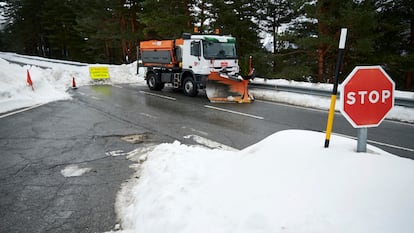
Around 60 roads in Spain were affected on Wednesday by bad weather in the north of the peninsula, according to the 10am bulletin from the DGT traffic authority. The worst-affected regions were Aragón, Asturias and Castilla y León, with four of the country’s main freeways affected. Storm Barra is complicating the return journey of many motorists who have taken advantage this week of two national holidays in Spain (December 6 and 8), with 25 provinces on alert today for winds, snow, landslides and high waves, according to the Aemet weather agency.
The DGT warned that snowfall forecast for the north of the peninsula today and tomorrow could affect all types of roads. Earlier this week, the same agency recommended that travelers return home a day early from their long weekend breaks given the bad weather forecast.
In total, 13 provinces in Spain – in the north, northwest and Pyrenees – saw their roads affected on Wednesday morning, most of them secondary routes. Huesca was the province with the most complications today, with as many as 11 routes on red alert, meaning snow chains were obligatory.
These affected roads included the A-23 at Nueno, the A-135 at Torla and the A-138 at Bielsa. The latter two were at black alert, meaning they were completely impassable due to the snow.
A further eight roads were on black alert: three in Navarre (Ochagavía and Belagua); two in Cantabria (Puerto de Palombera and San Roque de Riomiera) and La Rioja (Ortigosa de Cameros and Puerto de Montenegro); and one in Castilla y León (Burgos).
The Interior Ministry on Wednesday activated emergency Civil Protection plans in Aragón, Catalonia and the Balearic Islands given the bad weather conditions. In Aragón, heavy snow is forecast in Zaragoza and Huesca provinces, while the Balearic Islands and Catalonia are likely to see strong winds.
📢 Por ❄️ hay 60 vías afectadas:
— Dir. Gral. Tráfico (@DGTes) December 8, 2021
➡️ 2 de la red principal:
🟢 Transitable con precaución:
La #AP66 desde #Lena, en #Asturias, hasta Valverde de la Virgen, en #León.
La #A6: en León, en #Brazuelo y en #Lugo, en O Corgo.
➡️ Y 58 secundarias.
Más ℹ️: @InformacionDGT pic.twitter.com/KmdJ1Fxz10
This tweet from the DGT today explains that 60 routes are affected by snow.
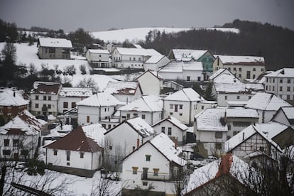
According to Aemet, a cold front is due to continue its progress along the southeast of the peninsula and the Balearic Islands. It will get weaker, the forecast predicts, but it will also lead to a flow of cold, humid and unstable air from west to the northwest. Heavy showers and some storms are expected in Galicia, Cantabria and the Pyrenees. The rain is likely to spread toward the south and east, with heavier showers likely in mountainous areas and the Strait of Gibraltar.
In the Cantabrian mountains, the Pyrenees and the Iberian mountain range there will be snowfall between 500 and 1,000 meters of altitude, with very strong winds on the northern coasts and the Balearics, as well as in mountain areas.
Nine provinces are on orange alert (medium risk): Burgos, Palencia and León, due to snowfall; while Vizcaya, Cantabria, Asturias, Lugo, A Coruña and Pontevedra are likely to see adverse conditions on their coasts.
On yellow alert (low risk) due to snow are Ávila, Segovia, Soria, La Rioja, Burgos, Álava, Guipúzcoa (also due to heavy waves), León, Orense, Zamora, Lugo, Cantabria and Asturias. Lleida, Huesca and Navarre are on alert due to snow and landslides, while Madrid, Murcia and Albacete are on yellow alert for wind, and Almería and Granada for wind and coastal conditions.
A chance of storms and fog
This afternoon, showers in Ampurdán and the Balearics are likely with a chance of storms. In the Canary Islands, there will be cloudy skies with some rain in the north of the islands with higher altitude.
Also later today, there will be snow between 500 and 1,000 meters of altitude in the extreme north, 600 to 1,000 in the central areas and 900 to 1,200 in the southeast. This means there will be snow in most of the country’s mountainous areas. The snow is likely to be very heavy in western Cantabria, areas of the Pyrenees and some coastal areas of Cantabria as well. There is a chance of fog in mountainous areas and inland parts of the peninsula too.
Temperatures are due to fall considerably throughout the peninsula, in particular in the northwest, Cantabria and the mountainous areas of the southeast. Frost is likely in the mountainous areas of the north and southeast, and the Pyrenees. They will hold steady, however, in the Balearic and Canary Islands.


