The hidden geography under the Strait of Gibraltar
New study on the movement of currents can help gain a better understanding of climate change

Even on the surface of things, the Strait of Gibraltar is unique. Stretching just 14.4 km from southern Spain to the northern coast of Africa, it forms an oceanographic gateway connecting two water masses – the Mediterranean and the Mid-Atlantic – and even this distance appears to diminish on clear days.
But beneath the choppy waters, there is another world at work. And in order to make the invisible visible, oceanographer Ricardo Sánchez and marine geologist Luis Miguel Fernández are working with an international research team to chart the itinerary and behavior of the Mediterranean current that flows into the Atlantic with such force that it can change the topography – which is now mapped in high resolution –developing into an impressive channel system that can ultimately affect the climate.
The Gulf of Cadiz is unique because the overflow processes of dense water are not often seen beyond the Norwegian Sea, the Danish Straits and the Red Sea
Ricardo Sánchez, researcher
“A less focused image already exists of this process. But now we have managed to document it in unprecedented detail,” says Sánchez, referring to research that began in 2009, involving field and laboratory work and data analysis. The Spanish Institute of Oceanography, to which both Sánchez and Fernández belong, has participated in the project, as has the Superior Council of Scientific Research (CSIC) and the universities of Malaga, the Algarve, Lisbon and Royal Holloway in London. The results of their findings have just been published in Science Advances.
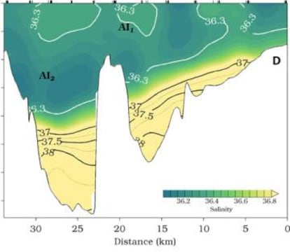
Two superimposed currents are formed in the Strait. The Mediterranean Outflow is saltier and therefore denser and flows along the bottom as it makes its way towards the Atlantic, while the Atlantic current, which is less salty and dense, flows into the Mediterranean closer to the surface.
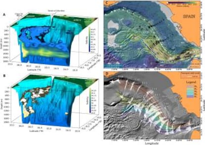
The channels created by the salty current when it becomes a fully developed and erosive bottom current are capable of forking off towards the Azores Islands and Ireland. “It emerges from the Strait in a single stream,” explains Sánchez. “And it cascades, forking off into different channels that hug the continental shelf. It opens on the outer reaches like the curves of a river.”
This kind of underwater dynamic is not common. “The Gulf of Cadiz is unique because the overflow processes of dense water are not often seen beyond the Norwegian Sea, the Danish Straits and the Red Sea,” he says.
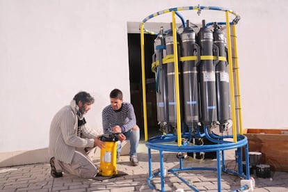
The singular nature of the phenomenon is what prompted Sánchez and his colleagues to carry out a number of field trips, using vessels from the Spanish Institute of Oceanography and a range of measuring instruments anchored to a rosette, which is a cylindrical instrument capable of reaching great depths, equipped with bottles for collecting water samples.
At different points along the first 200 km of the Gulf of Cadiz, the instruments gathered data on the direction, speed and intensity of the Mediterranean current, as well as the temperature, saltiness, and turbulence of the water. Anything not picked up by the sensors was subsequently found by analysis in the laboratory.
The bathymetric features of the seabed were also mapped thanks to the echo sounders fitted in the hulls of the ships, providing the exact morphology of the bottom of the Strait – valuable information that helps complete existing maps of areas close to the Mediterranean seabed.
If you could drain the water in the Strait, it would reveal an intricate terrain of valleys and peaks and ridges and mud volcanoes. Just 60 km west of Cadiz, an impressive underwater mountain range rises to rival the Sub-Baetic mountain range in southern Spain. This complex topography that ranges from 360 meters to 1,500 meters below sea level was largely created by the force of millions of cubic meters of water per second.
In the powerful overflow from the Mediterranean, there is a single stream that comes up against a sharp terrain and divides into diverse channels which, despite being diluted by less saline water, continue their course for hundreds of kilometers. “The exact history of the curved and forked geomorphology of the Strait of Gibraltar remains something of a mystery. However, it has consequences for ocean dynamics,” says Sánchez. “And it has been happening for the past five million years.”
The research has practical implications, the most important being its contribution to climate research. “It can help us understand how climate works in the North Atlantic,” says Sánchez, referring to the North Atlantic Deep Water that is formed by “the massive underwater current driven by the ocean conveyor belt that defines the global climate.”
The most recent research suggests a slowing of this massive underwater current, due to the ice melts in Greenland, triggered by global warming. As though addressing the issue, the Mediterranean Outflow that reaches the North Atlantic Deep Water has a fundamental role in maintaining this current, according to Sánchez. The injection of this dense and salty water into the Atlantic could serve to slow the effects of global warming on the formation of these deep waters as surface buoyancy on the northern seas are diminished.
“We have managed to obtain a static image of this phenomenon of the outflow,” says Sánchez. “Now we want to find out the seasonal variability. This was just the first step.”
English version by Heather Galloway.


