La Palma volcanic eruption: Find out how the lava would affect your city
Look up any place on this map to compare the scale of the devastation from the molten rock, which now covers more than 591 hectares
Comparing the size of the lava delta (image from October 6) with the surface area of famous buildings gives some idea of its actual dimensions. The lava platform extends 40 hectares, an area slightly smaller than that of the Vatican City, but larger than St Peter’s Basilica.
The eruption of the new volcano on La Palma, in Spain’s Canary Islands, has dramatically changed the face of the region. So much so, that some maps of the island will have to be redrawn.
The lava that has flowed into the Atlantic Ocean has changed the coastline of La Palma by creating a lava delta measuring around 40 hectares, an area big enough to fit Egypt’s Great Pyramid of Giza or Brazil’s Maracanã soccer stadium. In addition to creating a lava platform in the sea, the river of molten rock has also engulfed more than a thousand buildings on its path to the ocean. So far, more than 591 hectares have been affected by the lava since the volcano began to erupt on September 19. Far from insignificant, this area is large enough to fit Beijing’s Forbidden City four times over or New York’s Central Park. Compare the size of the area devastated by the lava with any city or location in the world by searching the map below.
×
Cargando
“We will have to update La Palma’s cartography in areas where it has been covered by lava and where the landscape has obviously changed and buildings, roads and infrastructures have disappeared,” explains Marcos Pavo López, head of the Central Registry of Cartography at Spain’s National Geographic Institute (IGN). “That area will have to be represented on a land-use map as a volcanic area.” What now looks like nothing more than land devastated by lava may evolve into something very different in the future. Timanfaya National Park, in the nearby Canary Island of Lanzarote, for example, is the result of several volcanic eruptions, one of which happened in 1730 and lasted six years.
The new maps will also need to take into account the area the lava has reclaimed from the sea, which is large enough to be perceptible on maps of a certain scale. According to Pavo López, “the size of the area that has been created now would be quite imperceptible on a small scale, but would be noticeable at a scale of 1:25,000 [one centimeter on the map represents 25,000 centimeters] or 1:50,000, which are the scales the IGN works up to.”
Maps are designed with different levels of detail and are drawn to different scales, depending on their intended use.
More detail
Bigger scale maps are designed with more detail and can be enlarged without losing accuracy.
Scale
1-100.000
1-500.000
1-10 million
To see the entire world, this level of precision is not required and smaller scales are used.
1-50 million
Less detail
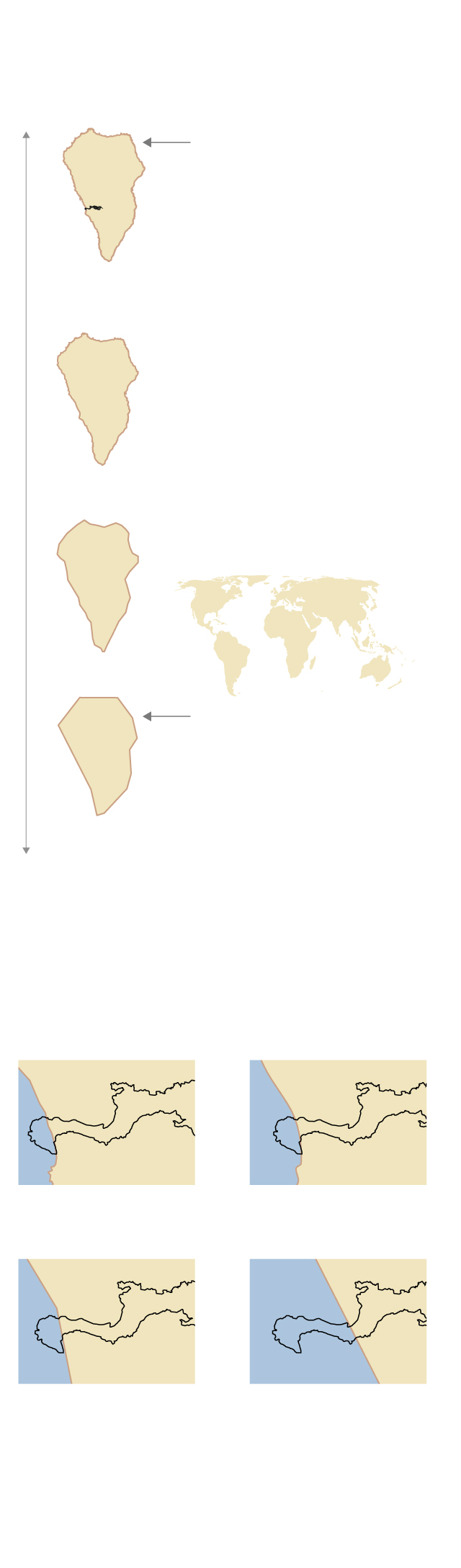
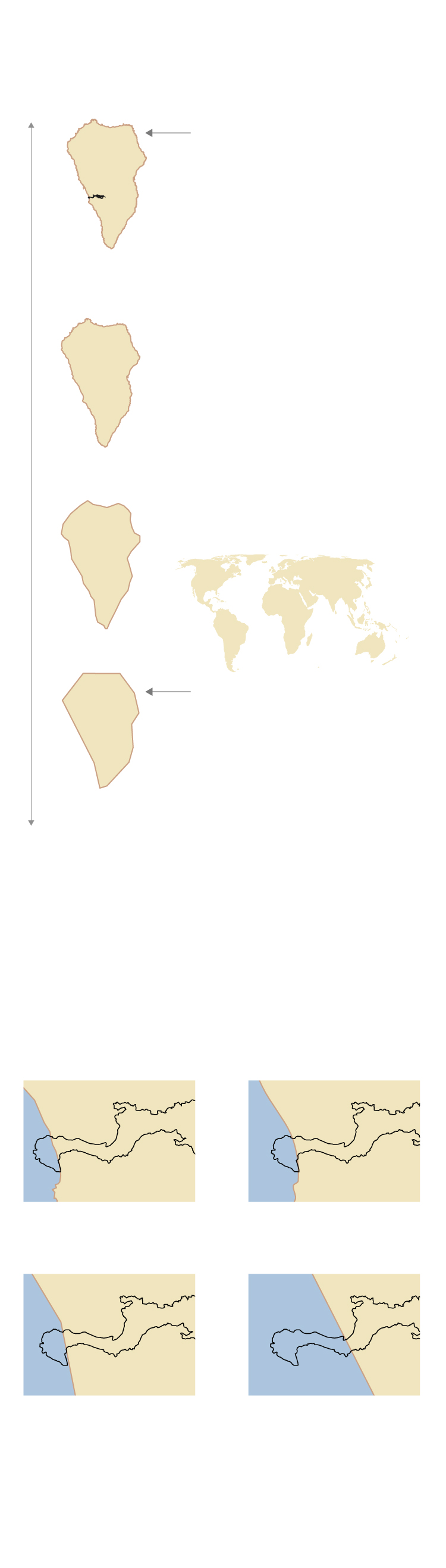
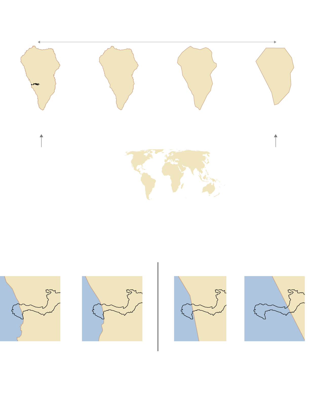
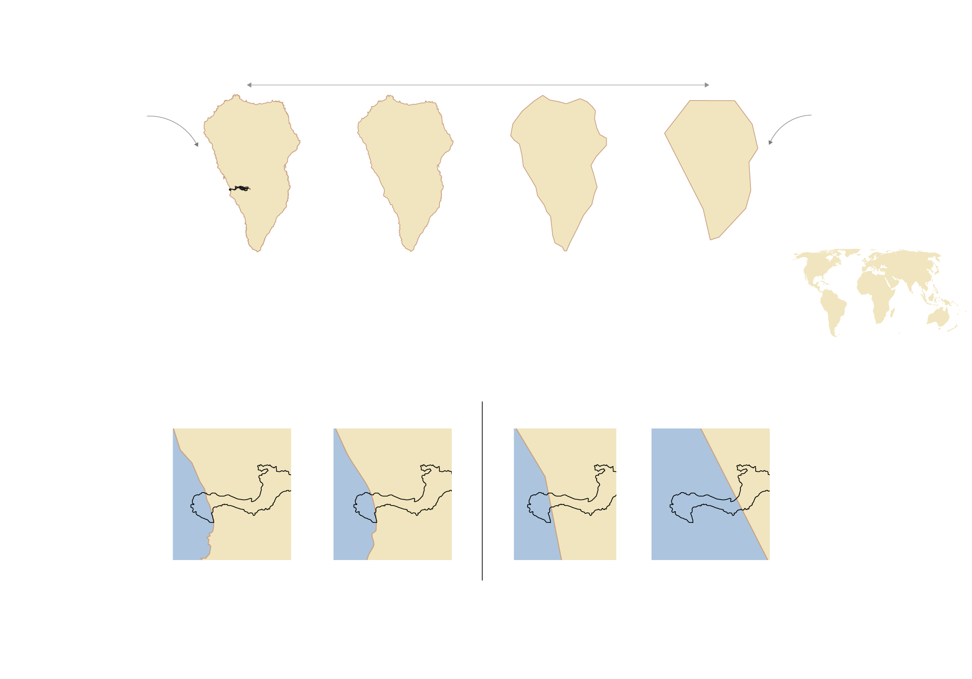
The eruption of the volcano on La Palma will mean maps will need to be redrawn only if they are drawn to a scale in which a specific degree of detail can be appreciated.
Maps that will have to be redrawn
Lava
1-100.000
1-500.000
Maps that won’t have to be redrawn
1-10 millones
1-50 millones
All maps showing roads and infrastructure destroyed by the lava will also have to be changed.
Source: IGN and Natural Earth.
Maps are designed with different levels of detail and are drawn to different scales, depending on their intended use.
More detail
Bigger scale maps are designed with more detail and can be enlarged without losing accuracy.
Scale
1-100.000
1-500.000
1-10 million
To see the entire world, this level of precision is not required and smaller scales are used.
1-50 million
Less detail
The eruption of the volcano on La Palma will mean maps will need to be redrawn only if they are drawn to a scale in which a specific degree of detail can be appreciated.
Maps that will have to be redrawn
Lava
1-100.000
1-500.000
Maps that won’t have to be redrawn
1-10 millones
1-50 millones
All maps showing roads and infrastructure destroyed by the lava will also have to be changed.
Source: IGN and Natural Earth.
Maps are designed with different levels of detail and are drawn to different scales, depending on their intended use.
More detail
Less detail
La Palma
Scale
1-100.000
1-500.000
1-10 million
1-50 million
To see the entire world, this level of precision is not required and smaller scales are used.
Bigger scale maps are designed with more detail and can be enlarged without losing accuracy.
The eruption of the volcano on La Palma will mean maps will need to be redrawn only if they are drawn to a scale in which a specific degree of detail can be appreciated.
Maps that will have to be redrawn
Maps that won’t have to be redrawn
Lava
1-100.000
1-500.000
1-10 million
1-50 million
All maps showing roads and infrastructure destroyed by the lava will also have to be changed.
Source: IGN and Natural Earth.
Maps are designed with different levels of detail and are drawn to different scales, depending on their intended use.
More detail
Less detail
To see the entire world, this level of precision is not required and smaller scales are used.
Bigger scale maps are designed with more detail and can be enlarged without losing accuracy.
La Palma
1-50 million
Scale:
1-100,000
1-500,000
1-10 million
The eruption of the volcano on La Palma will mean maps will need to be redrawn only if they are drawn to a scale in which a specific degree of detail can be appreciated.
Maps that won’t have to be redrawn
Maps that will have to be redrawn
Lava
1-100.000
1-500.000
1-10 million
1-50 million
All maps showing roads and infrastructure destroyed by the lava will also have to be changed.
Source: IGN and Natural Earth.
It is still not clear when the small lava delta, which has not yet consolidated, will be incorporated into the new maps. “Right now map-making is based on photogrammetric flights, which allow digital photographs to be taken, at intervals of between two or three years,” says Pavo López, who points out that the first Spanish topographic map took almost 100 years to complete. “The first map, which was of Madrid, was made in 1875 and it wasn’t until 1968 that the entire territory was covered,” he says, explaining that this coincided with the publication of the map of San Nicolás de Tolentino, the westernmost municipality on the island of Gran Canaria. “That said, from the 1970s onwards, the process was vastly speeded up, thanks precisely to the use of photogrammetry.”
But while land maps will have to be altered, the priority is modifying nautical charts, which are the responsibility of the Navy’s Hydrographic Institute. “This presents a trickier problem,” says Pavo López. “What emerges on the sea’s surface is visible and therefore not problematic, but the lava flow that has fallen into the ocean has changed the depth and that is not visible.” The nautical charts not only reflect the shape of the coast but also “the obstacles and depths in the worst-case scenarios – meaning at low tide.” As he points out: “A ship with a certain keel needs to know how far it is to an obstacle or to the bottom when the tide is at its lowest.” And although the new edition of the chart will take some time to be published, the current ones, both digital and in paper version, will warn navigators of the new obstacles, with a sticker generally being used on print maps.
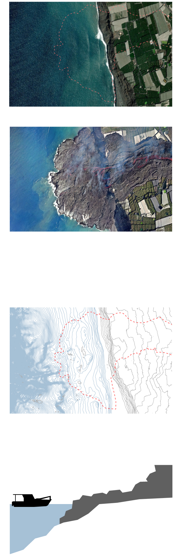
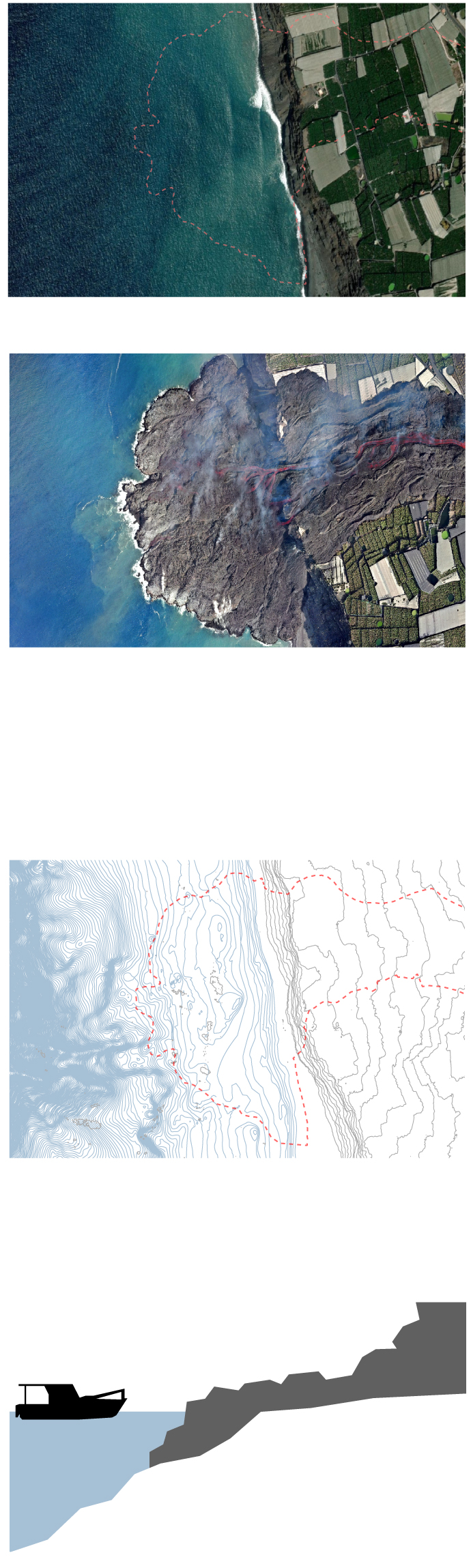
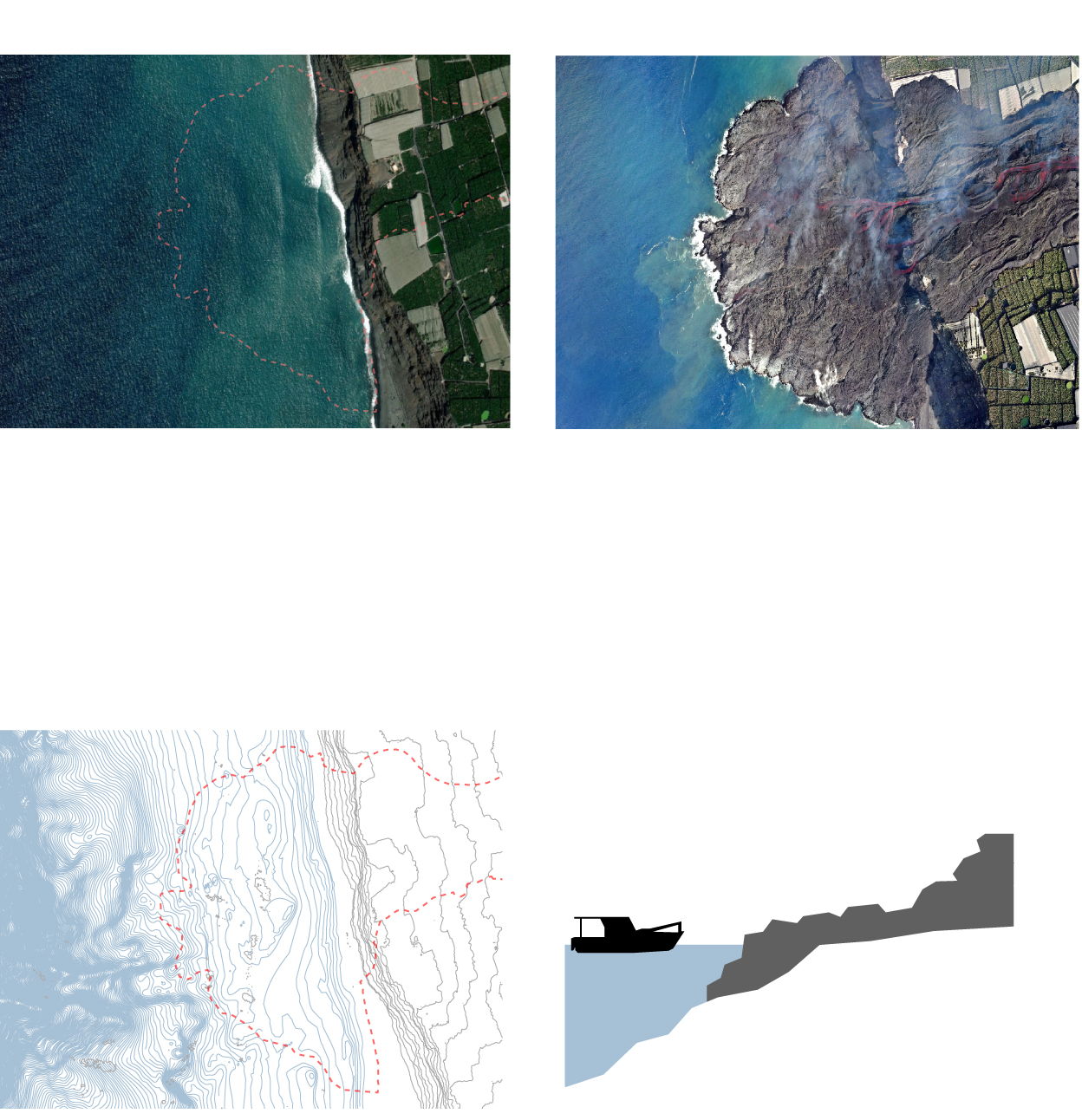
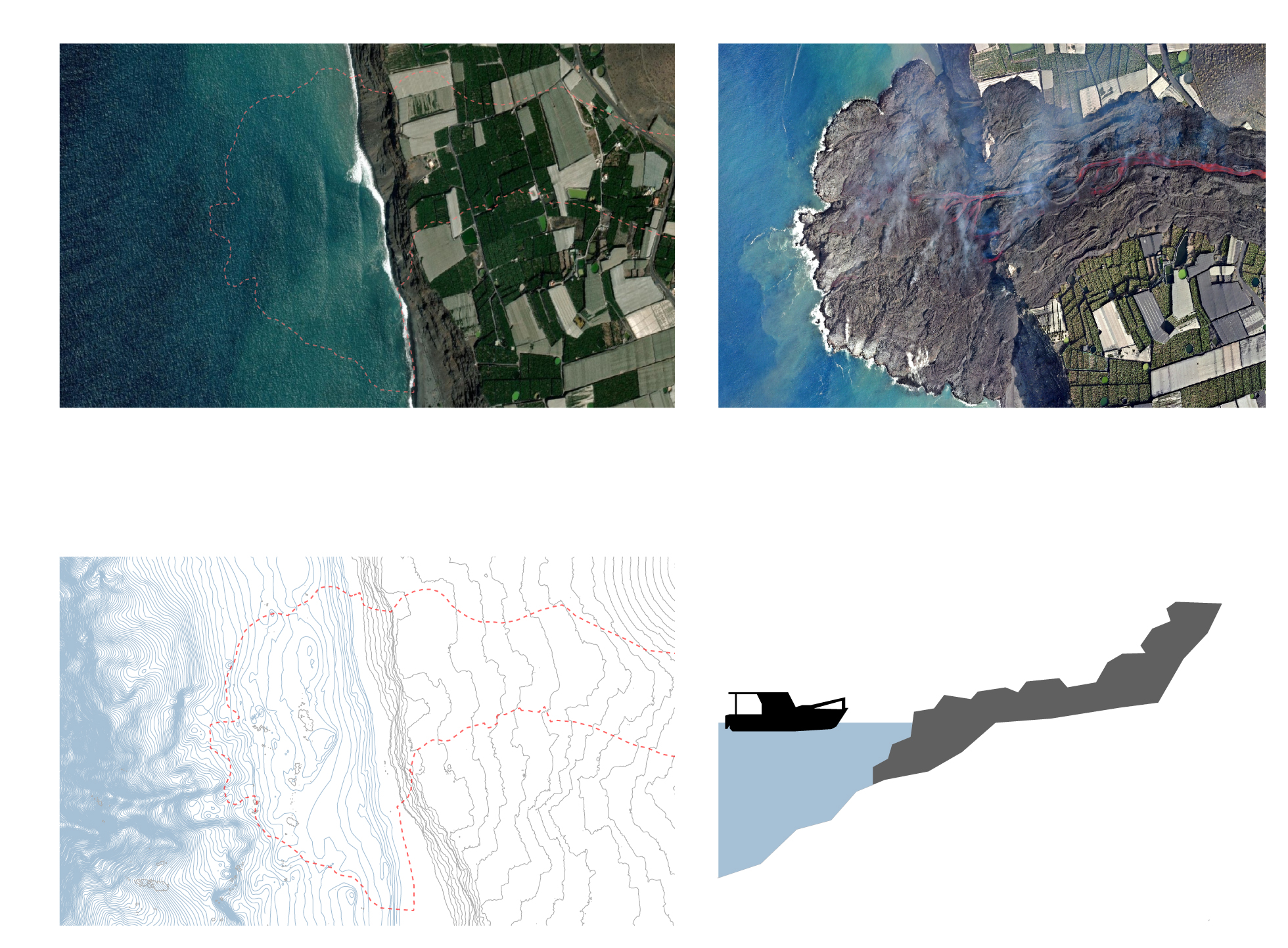
Before the eruption
ESRI satellite image
After the eruption
Drone image from La Palma island
council on October 6
The eruption has modified the ocean floor and, with it, the depth data reflected in nautical charts such as this one.
Depth in meters
-120
-60
-20
-10
-1
100
150
Ships will need new accurate data to navigate when approaching the coast.
Simplified diagram
Before the eruption
After the eruption
ESRI satellite image
Drone image from La Palma island
council on October 6
Ships will need new accurate data to navigate when approaching the coast.
The eruption has modified the ocean floor and, with it, the depth data reflected in nautical charts such as this one.
Simplified diagram
Depth in meters
-120
-60
-20
-10
-1
100
Before the eruption
After the eruption
ESRI satellite image
Drone image from La Palma island council on October 6
The eruption has modified the ocean floor and, with it, the
depth data reflected in nautical charts such as this one.
Ships will need new accurate data to navigate when approaching the coast.
Simplified diagram
Depth in meters
-120
-60
-20
-10
-1
100
150
More changes
But changing maps and nautical charts is just one consequence of the volcanic eruption. “The official surface of both the municipality of Tazacorte and the island of La Palma will have changed,” explains Pavo López, meaning the IGN will have to issue a “new certification” corresponding to its new surface area, a document that Pavo López will sign and that is used, among other things “for the distribution of certain subsidies and grants that are in proportion to the surface area.”
Meanwhile, the maritime borders, which are 12 nautical miles from the coastline, will also change as will the exclusive economic zone which extends 200 nautical miles out to sea from the base of the coast, an area over whose marine resources Spain exercises special exploitation rights.