The underwater ‘hotspot’ feeding La Palma’s volcano will create new islands
The magma flow that shaped Spain’s Canaries archipelago 20 million years ago continues to add landmass, while Fuerteventura and Lanzarote are destined to sink under the effects of erosion

Lithosphere
Lava
flow
Asthenosphere
Mantle
Simplified outline of the geological evolution
of the Canary Islands over 20 million years.

Atlantic Ocean
Younger islands
Older islands
Lithosphere
Lava
flow
Asthenosphere
Mantle
Simplified outline of the geological evolution of the Canary Islands over 20 million years.
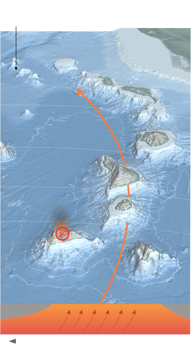
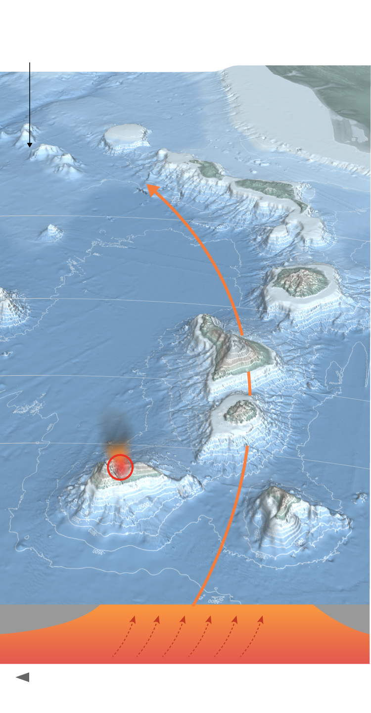
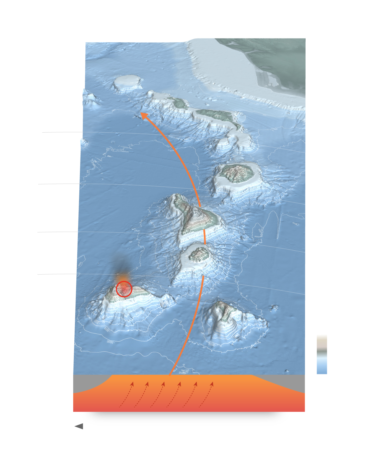
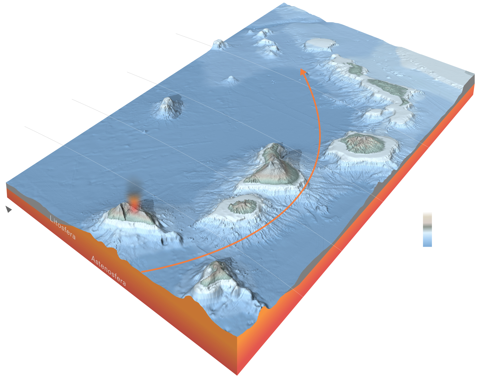
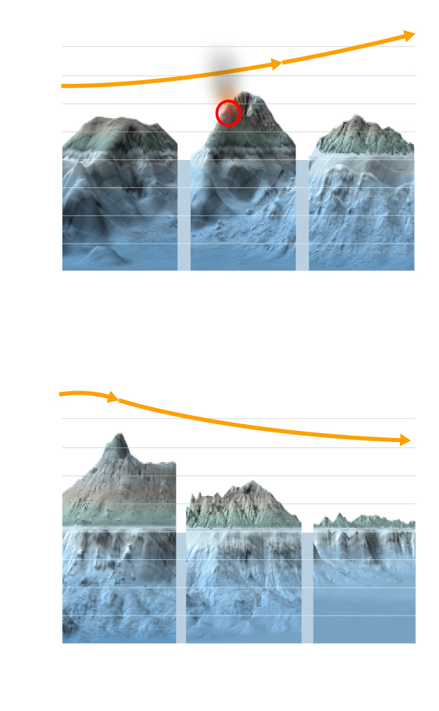
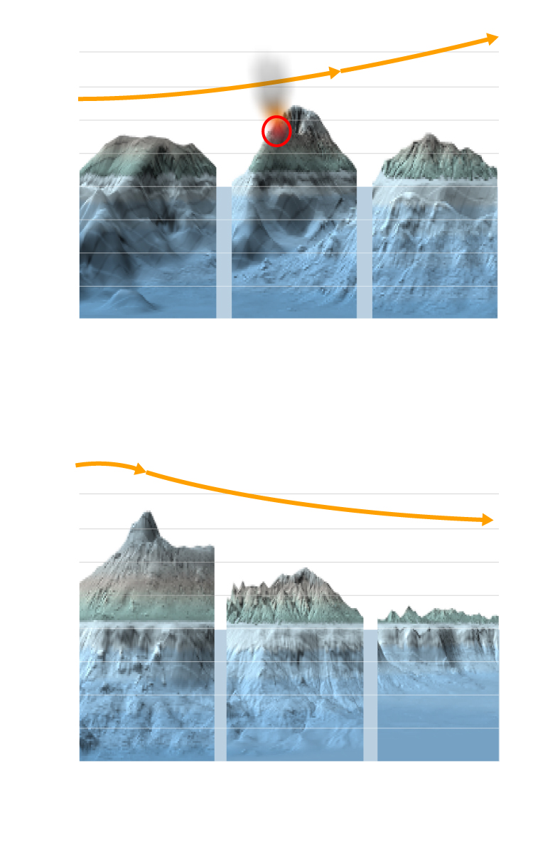
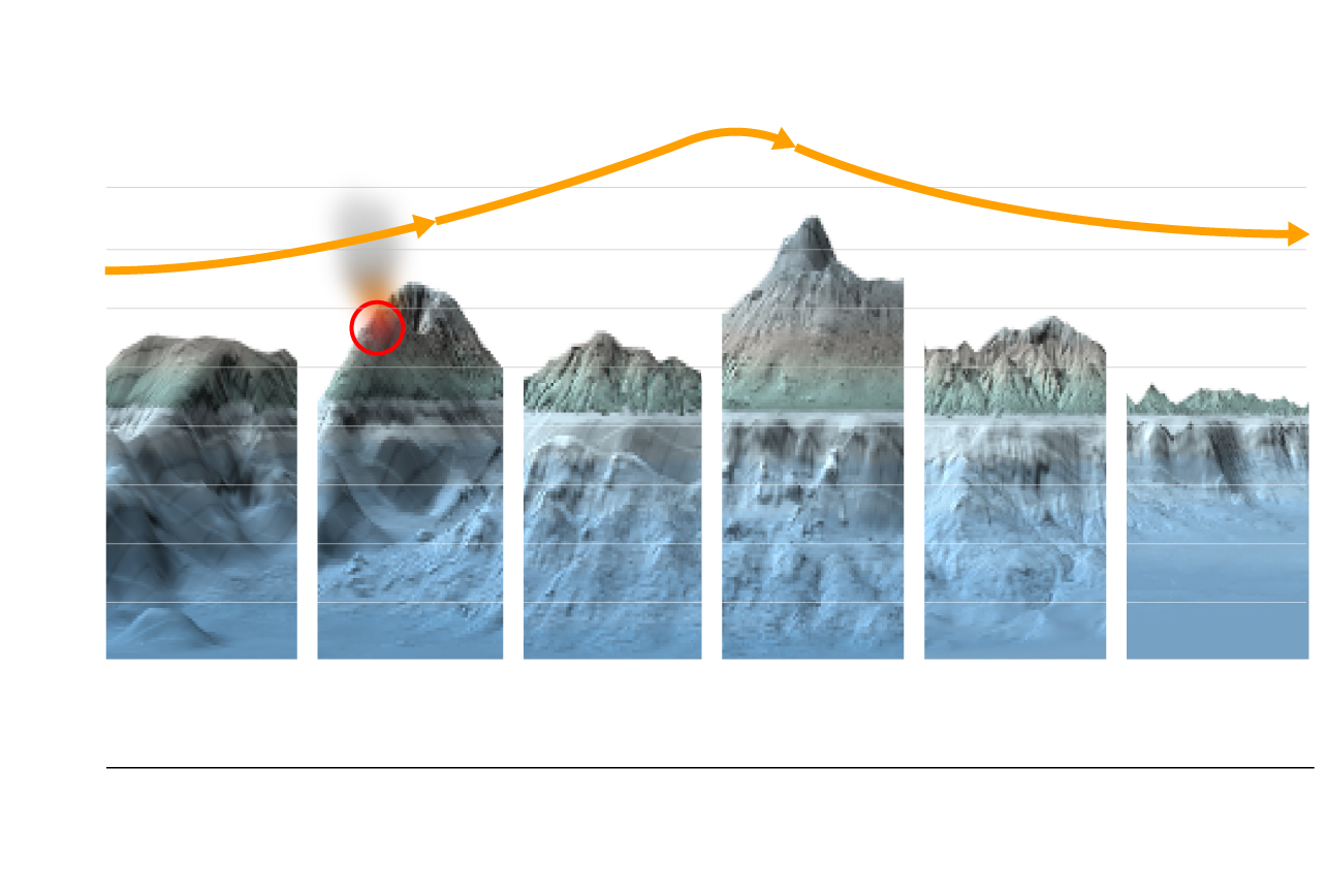
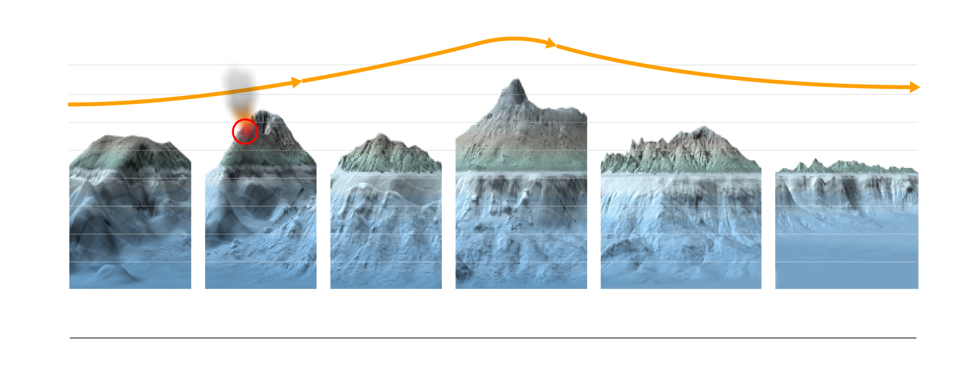
The Canary Islands lie on the African Plate, which “floats” over the Earth’s mantle in an easterly direction, moving at a speed comparable to the growth of fingernails. About 20 million years ago, the plate started to move over the “hotspot” that injected magma and began to create the first islands – now the oldest islands – of Fuerteventura and Lanzarote. La Palma and El Hierro are the youngest islands, at just 1.8 million and 1.2 million years old respectively. The hotspot is still beneath them and that is why they have active volcanoes that make them grow and extend in surface area.
Formation of the islands
Millions of years
ÁFRICA
-1,500
-500
Lanzarote
20.2
Fuerteventura
-3,000
Progression
by age of the
islands
14.5
Gran Canaria
El Teide 3,715 m
11.9
Tenerife
9.5
La Gomera
El Hierro
1.8
La Palma
Atlantic
Ocean
-3,500
-4,000
Litosphere
Asthenosphere
Mantle
North
Formation of the islands
Millions of years
ÁFRICA
-1,500
-500
Lanzarote
20.2
Fuerteventura
-3,000
Progression
by age of the
islands
14.5
Gran Canaria
El Teide 3,715 m
11.9
Tenerife
9.5
La Gomera
El Hierro
1.8
La Palma
Atlantic
Ocean
-3,500
-4,000
Litosphere
Asthenosphere
Mantle
North
Formation of the islands
Millions of years
ÁFRICA
-1,500
-500
Lanzarote
20.2
Fuerteventura
-3,000
Progression
by age of the
islands
14.5
Gran Canaria
El Teide 3,715 m
11.9
Tenerife
9.5
La Gomera
El Hierro
1.8
La Palma
Altitude
3,500
Atlantic
Ocean
0
-3,500
-4,000
-4,000
Litosphere
Asthenosphere
Mantle
North
20.2
Formation of the islands
Millions of years
-1,000
14.5
-500
Lanzarote
ÁFRICA
Fuerteventura
11.9
Progression
by age of the
islands
9.5
Gran Canaria
Tenerife
Atlantic Ocean
1.8
-3,500
El Teide 3,715 m
La Gomera
-3,000
La Palma
Altitude
3,500
North
0
-4,000
-3,500
-3,000
El Hierro
Mantle
This maps shows the submarine relief of all the Canary Islands and their surroundings, complete with other now extinct volcanoes that emerged as islands millions of years ago, such as those seen to the north of Lanzarote.
Altitude
4,000
Birth
2,000
0
-2,000
-4,000
El Hierro
La Palma
La Gomera
Maximum
growth
Dismantling
4,000
Teide 3,715 m
2,000
0
-2,000
-4,000
Tenerife
Gran Canaria
Fuerteventura
y Lanzarote
Altitude
4,000
Birth
2,000
0
-2,000
-4,000
El Hierro
La Palma
La Gomera
Maximum
growth
Dismantling
4,000
Teide 3,715 m
2,000
0
-2,000
-4,000
Tenerife
Gran Canaria
Fuerteventura
and Lanzarote
Maximum
growth
Altitude
Dismantling
4,000
Birth
Teide 3,715 m
2,000
0
-2,000
-4,000
El Hierro
La Palma
La Gomera
Tenerife
Gran Canaria
Fuerteventura
and Lanzarote
Less than 2
9.4
14.5
20
million years
Maximum growth
Dismantling
Altitude
4,000
Birth
Teide 3,715 m
2,000
0
-2,000
-4,000
Fuerteventura
and Lanzarote
El Hierro
La Palma
La Gomera
Tenerife
Gran Canaria
Less than 2
9.4
14.5
20
million years
Volcanologists believe that the magma flow is currently under La Palma. In 2011, it created a submarine volcano close to the island of El Hierro that almost reached the surface. This is how all the islands, which are actually huge volcanoes, originated. From the bottom of the sea, La Palma is about 6,500 meters high – almost as tall as the highest peak of the Andes. Similarly, the oldest islands, Fuerteventura and Lanzarote, are disappearing through erosion and will eventually be submerged.
“The volcanic eruption of La Palma is undoubtedly the most destructive one in Spain’s history,” says Juan Carlos Carracedo, a 79-year-old geologist from the northern region of La Rioja who has spent most of his life studying volcanic activity in the Canary Islands, which are located off the northwestern coast of Africa. Since the Castilians conquered La Palma in 1493, there have been seven other recorded volcanic eruptions whose lava swept away houses, crops and even ports. But their impact was not as significant as the island was far less populated then and had not yet established economic engines of growth such as tourism or banana greenhouses. “Not even the Timanfaya on the island of Lanzarote in 1730 caused this much damage,” says Carracedo, a professor emeritus at the University of Las Palmas de Gran Canaria.

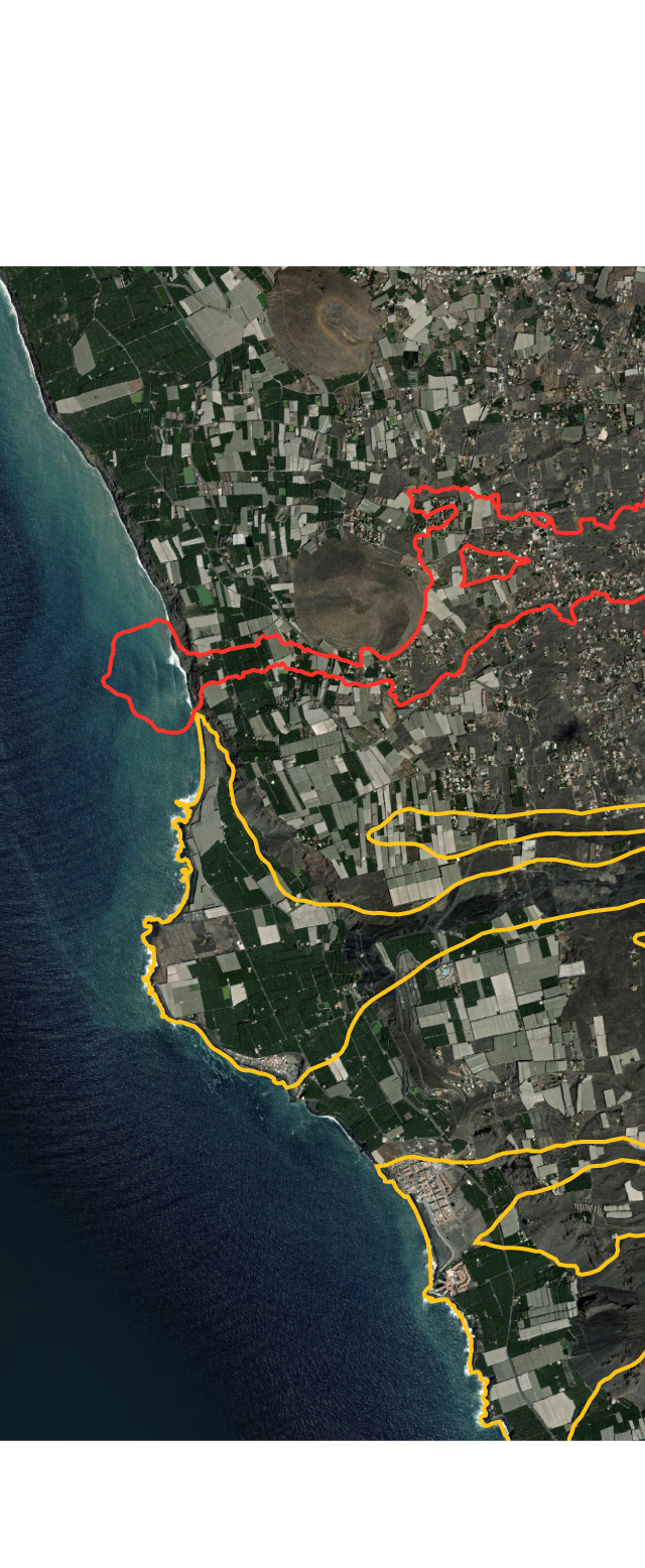
Lava tongue
Todoque
Todoque
Mountain
Altitude
110 m
90 m
Updated: October 1
0 m
-19 m
-60 m

Lava tongue
Todoque
Todoque
Mountain
Altitude
110 m
90 m
0 m
Lava advance updated with Copernicus data from October 1
-19 m
-60 m
The graphic above shows the eruption of the Cabeza de Vaca volcano on La Palma from September 21 to October 1. The rivers of lava have destroyed or damaged more than a thousand buildings, far more than recorded in other eruptions. It is the latest chapter in a history of volcanic activity that began more than 20 million years ago. It is both a destructive and creative phenomenon, for without volcanoes none of the Canary Islands would exist.
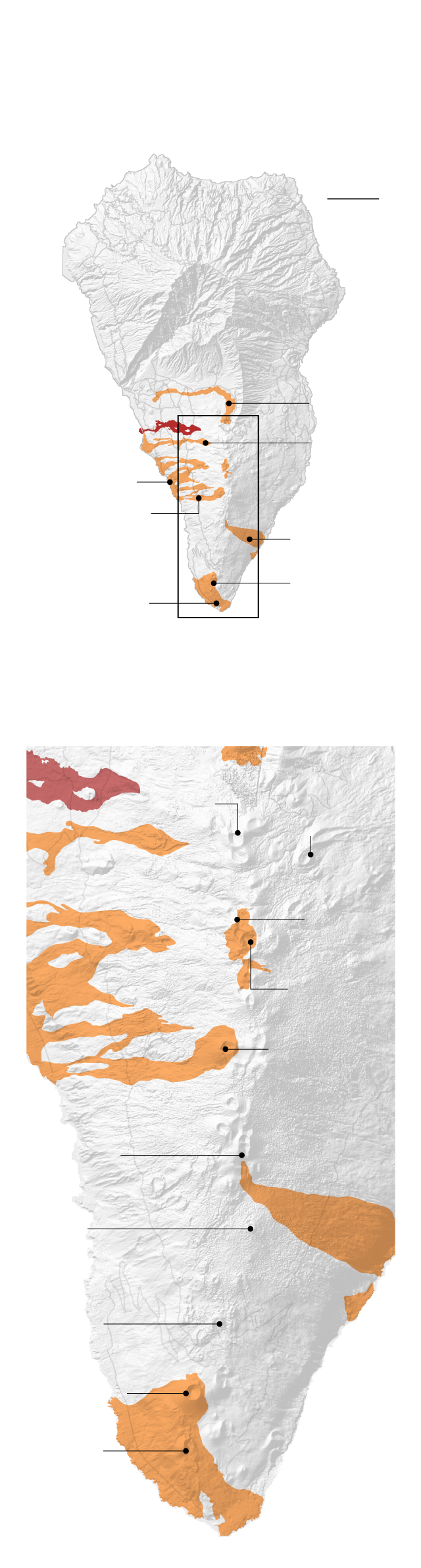
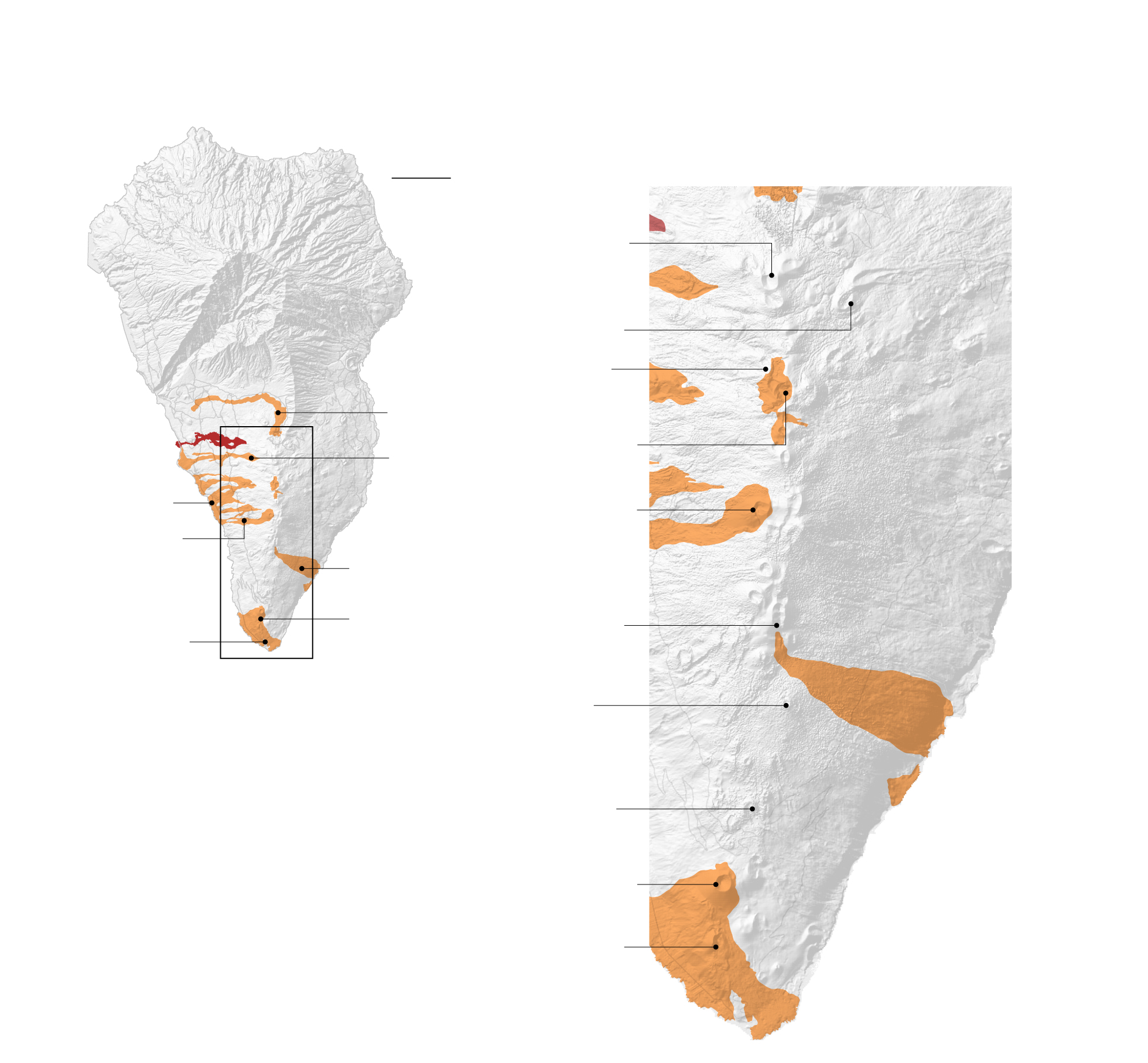
In the last five centuries, all La Palma’s volcanoes have emerged in Cumbre Vieja, a spectacular mountain range featuring almost 30 craters that extends to the south of the island. This is probably the only place in Spain where in just a few hours you can touch stones that originated in the last five centuries; it is the country’s youngest terrain.
As is the case now, the lava tongues of most of the previous eruptions advanced along the western slopes of Cumbre Vieja. Many of them reached the sea and created platforms that enlarged the surface of the island.
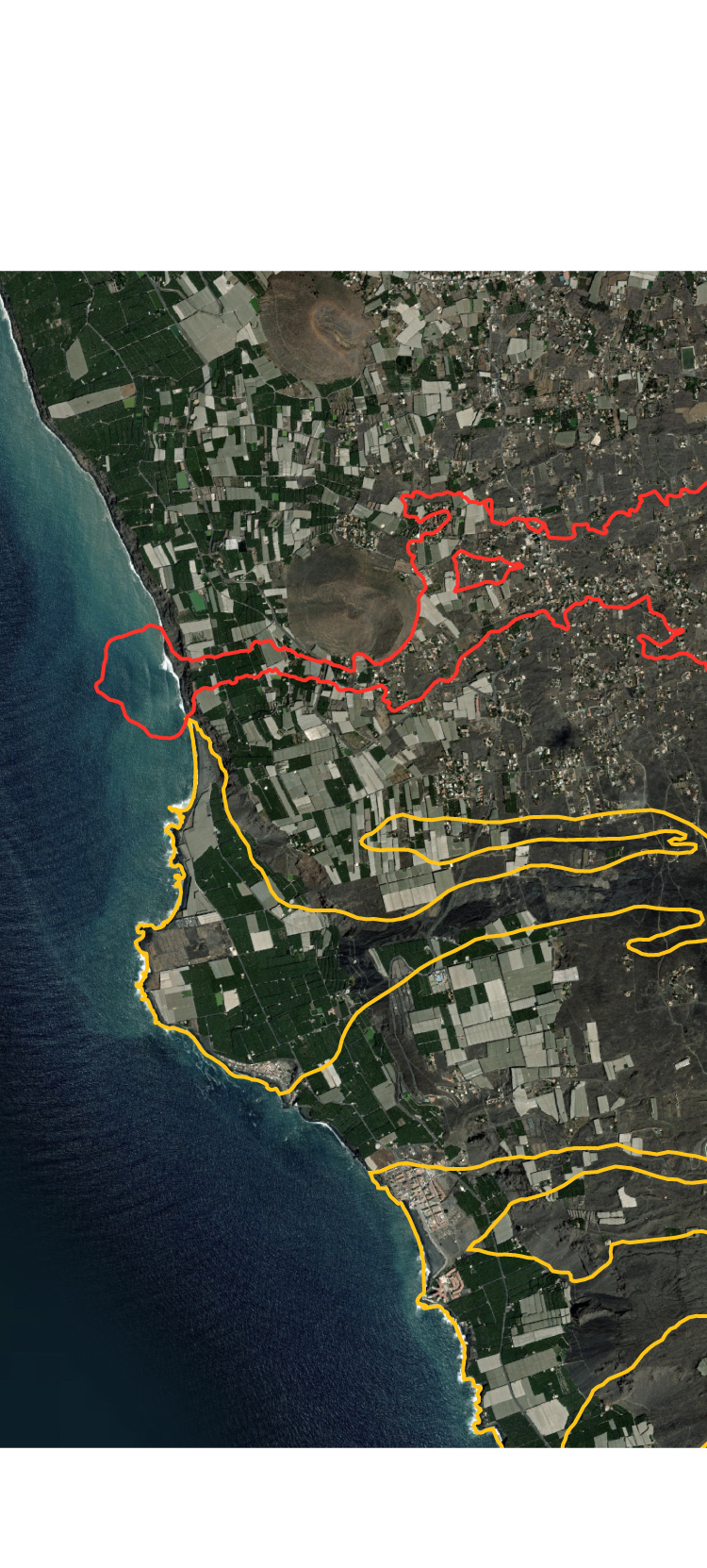
More active in the south
The volcanic mountain range extending south of La Palma is the youngest and most active area. The most-recent eruptions have occurred in this area.
5 km
La Palma
Caldera de Taburiente
1430
Tacande
2021
Cumbre Vieja
1949
San Juan
1585 Tahuya
Cumbre
Vieja
1712 El Charco
1646 Martín
1667
San Antonio
1971 Teneguía
The Cumbre Vieja Natural Park is a series of craters and active volcanoes.
San Juan
volcano
Caldero
mountain
Tahuya
volcano
Nambroque
mountain
Los Lajones
mountain
Cumbre Vieja
San Martín
volcano
Fuego
mountain
El Rivero
San Antonio
volcano
Teneguía
volcano
More active in the south
The volcanic mountain range extending south of La Palma is the youngest and most active area. The most-recent eruptions have occurred in this area.
The Cumbre Vieja Natural Park is a series of craters and active volcanoes.
5 km
La Palma
San Juan
volcano
Caldera de Taburiente
National Park
Caldero
mountain
Tahuya
volcano
1430
Tacande
2021
Cumbre Vieja
Nambroque
mountain
1949
San Juan
1585 Tahuya
Cumbre
Vieja
Los Lajones
mountain
1712 El Charco
1646 Martín
Cumbre Vieja
1667
San Antonio
San Martín
volcano
1971 Teneguía
Fuego
mountain
El Rivero
San Antonio
volcano
Teneguía
volcano
“The eruption that gained the most new land from the sea was the one in 1949,” explains Carracedo. “The area was covered with fertile soil brought from another part of the island and they planted banana trees – a tropical plant that grows best at sea level, meaning they are now among the most bountiful on the island.”
Land reclaimed from the sea
The current eruption and those during the last 500 years have caused the island to extend westward, leaving lava platforms on the seabed.
Todoque
2021
Cumbre Vieja
1949
San Juan
Puerto Naos
Algunas de las plantaciones de plátano canario más productivas de toda la isla se asientan hoy sobre la Land reclaimed from the sea por la erupción del volcán San Juan en 1949.
1585
Tahuya
Actualizado con datos de la erupción
del 1 de octubre de 2021 (Copernicus).
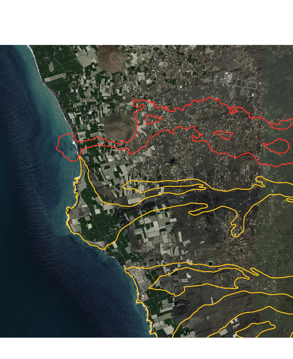
Land reclaimed from the sea
The current eruption and those during the last 500 years have caused the island to extend westward, leaving lava platforms on the seabed.
Todoque
2021
Cumbre Vieja.
So far, the eruption
has created more
than 30 hectares
of land on the sea.
1949
San Juan
Puerto Naos
Some of the most-productive banana plantations on the island are located on land reclaimed from the sea by the eruption of the San Juan volcano in 1949.
1585
Tahuya
Actualizado con datos de la erupción del 1 de octubre de 2021 (Copernicus)
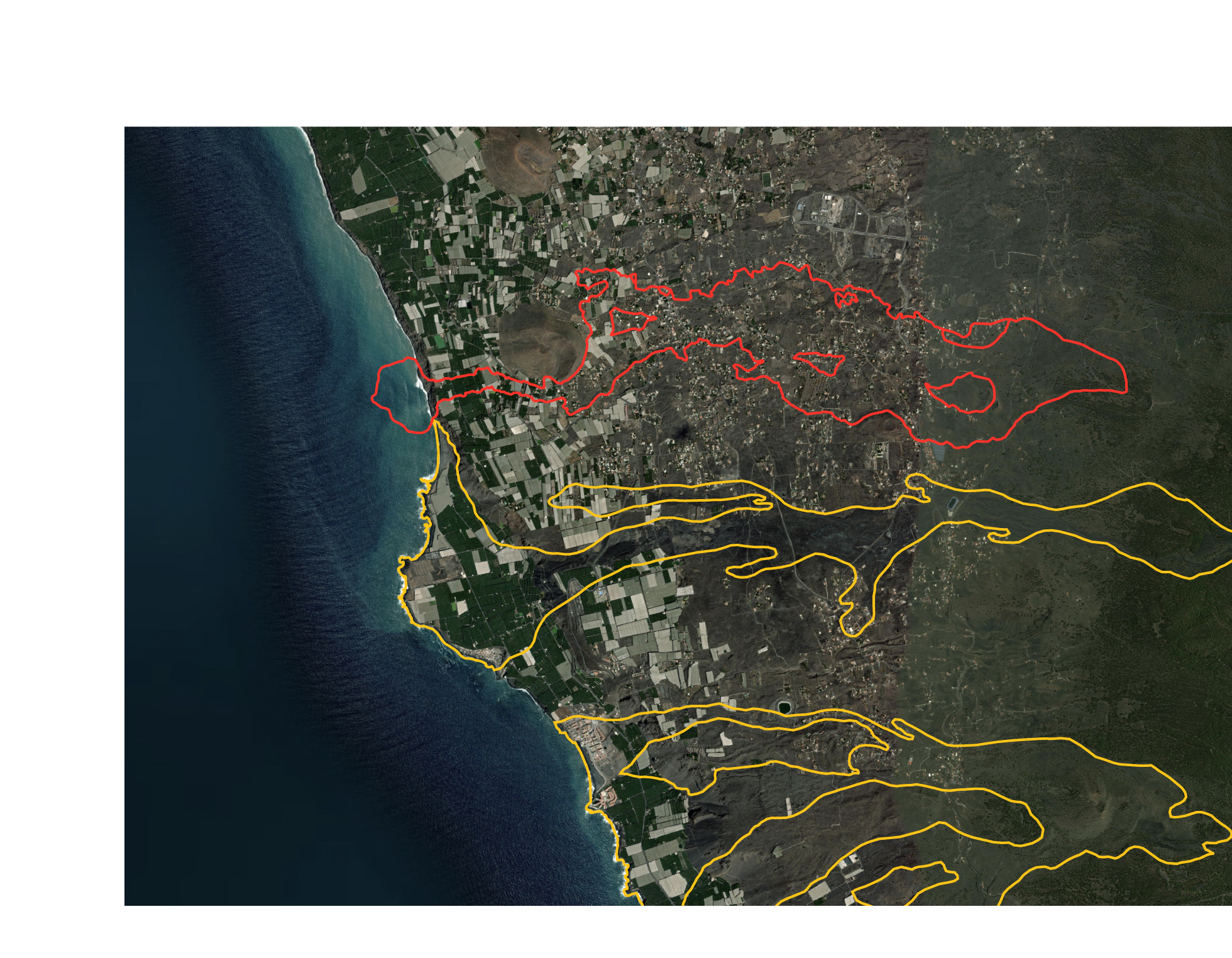
Land reclaimed from the sea
The current eruption and those during the last 500 years have caused the island to extend westward, leaving lava platforms on the seabed.
Todoque
2021
Cumbre Vieja.
So far, the eruption
has created more
than 30 hectares
of land on the sea.
1949
San Juan
Puerto Naos
Some of the most-productive banana plantations on the island are located on land reclaimed from the sea by the eruption of the San Juan volcano in 1949.
1585
Tahuya
Updated with data from the eruption as at October 1, 2021 (Copernicus)
One of the main questions about the La Palma eruption is where exactly the magma emerging from the mouth of the volcano comes from. Another question is whether it gushes out instantaneously or if it’s a gradual process that takes millions of years. Volcanologists think that under the Canary Islands there is a “hotspot,” a reservoir of extremely hot magma that continually seeks a way to emerge, producing earthquakes and buckling the surface of the islands until they crack. These cracks allow the magma to push through the crust to form volcanoes. This is the same type of volcanic activity that created the Hawaiian archipelago in the US. However, the hotspot theory is controversial because it does not fully explain all the activity in the Canary Islands; for example, the eruptions on old islands such as Lanzarote in relatively recent times.
“In the hotspot, the [temperature of the] magma is about 200º C higher, which makes it more buoyant,” explains Carracedo. “It’s the same as when you push a ball to the bottom of a pool and it shoots to the surface. This is the process that has created all the Canary Islands and is still going on. New islands will certainly emerge, always to the west, but we will not see any of them, because it will happen in millions of years.” In the same way, the oldest islands, Fuerteventura and Lanzarote, are gradually disappearing through a process of erosion and will end up under the sea.

Canary Islands
Lanzarote
Atlantic Ocean
Tenerife
La Palma
Fuert.
The sons
El Hierro
Gran Canaria
La Gomera
AFRICA
100 km
The grandmothers
The seabed of the Canary Islands is a string of submerged islands that were once above sea level. They are extinct volcanoes that are known to some scientists as Las abuelas, or “ the grandmothers.”
0
The grandmothers
-3,500
Atlantic Ocean
Canary Islands
Lanzarote
Tenerife
La Palma
Fuerteventura
La Gomera
The sons
-5,000 m
Gran Canaria
El Hierro
-4,000 m
The grandmothers
AFRICA
-4,000 m
-500 m
-1,000 m
100 km
-2,000 m
-3,000 m
The seabed of the Canary Islands is a string of submerged islands that were once above sea level. They are extinct volcanoes that are known to some scientists as Las abuelas, or “ the grandmothers.”
0
The grandmothers
-3,500
Atlantic Ocean
Canary Islands
Lanzarote
Tenerife
La Palma
Fuerteventura
La Gomera
The sons
-5,000 m
Gran Canaria
El Hierro
-4,000 m
AFRICA
The grandmothers
-4,000 m
-500 m
-1,000 m
100 km
-2,000 m
-3,000 m
The seabed of the Canary Islands is a string of submerged islands that were once above sea level. They are extinct volcanoes that are known to some scientists as Las abuelas, or “ the grandmothers.”
0
The grandmothers
-3,500
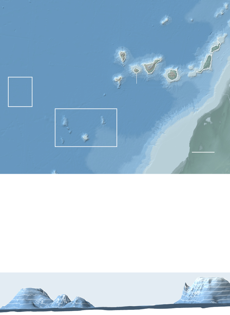
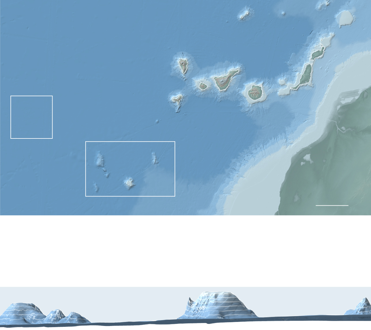
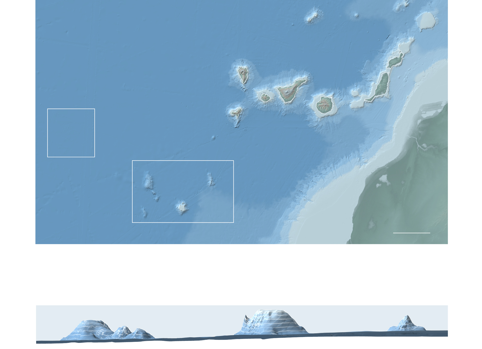
The map above shows where new Canary Islands may currently be in the process of being born. In 2017, a research vessel located an area 400 kilometers west of the island of El Hierro where they discovered new submarine volcanoes that have recently been active or may even be active now. They lie at a depth of about 5,000 meters. It makes perfect sense that they are to the west as it matches the movement of the Earth’s crust over the hotspot. “We believe that these are the embryos of the new Canary Islands,” explains Luis Somoza, a marine geologist with the Geological and Mining Institute of Spain (IGME) and a member of the 2017 expedition.
To the south of the aforementioned area, there are other extinct submerged volcanoes that some scientists call “las abuelas” or the grandmothers of the Canary Islands. They appeared about 120 million years ago due to the activity of another hotspot, emerging from the sea only to sink back again about 70 million years ago at around the time the dinosaurs were becoming extinct.
Many of these submerged islands were discovered only a few years ago by Somoza’s team. The shape of some of them is almost identical to the Canary Islands that are visible today, as if they were a sort of experiment; “a pre-Canary Islands,” as Somoza puts it.
Somoza has led several expeditions to study these submarine mountains – or seamounts as they are known – both those already identified and other new ones that have been baptized by his team: Drago, Bimbache, Ico, Pelicar, Malpaso, Tortuga and Las Abuelas.
The volcanoes of the Canary Islands are fundamental to Spain’s expansion of its maritime borders. The research carried out by Somoza’s team lends weight to an official petition to the United Nations arguing that some of the submerged islands form part of the Canary Islands and that, therefore, the exclusive economic zone that grants Spain special rights over those waters should be expanded. If the proposal is approved, a marine territory equivalent to half of mainland Spain could be gained, according to those responsible for the initiative.
“If part of the island collapses and falls into the sea, it becomes a natural extension of the land that is above the surface, so it would be within Spanish borders,” says Somoza. This is also the case with the debris that has formed a carpet over the seabed near El Hierro and could increase the exclusive economic zone by a radius of 60 miles. Somoza explains that “another way to grow is for a new island to emerge, as almost happened in 2011 after El Hierro’s underwater volcanic eruption. It was only 80 meters from the surface. If it had emerged, this would have been the new territorial boundary of El Hierro.” Somoza also notes that if the lava delta – where the lava meets the sea – created by the Cabeza de Vaca volcano continues to grow and surpasses those created by past eruptions, Spain’s borders will expand.
Luis Sevillano and Jacob Vicente López contributed to this story.
English version by Heather Galloway.
Sources: Roberto Rodríguez, editor of the geological guides to the National Parks of the Geological and Mining Institute of Spain, Copernicus satellite system, La Palma’s Cabildo Insular, the Geological and Mining Institute of Spain, Bing Maps, “Canaries: Intraplate Volcanic Islands” (Geo-Guías) and Science Direct (“The geology of La Palma”).