Weekend of wintry weather in Spain, with sharp drop in temperatures
First warnings of the season for Cantabria, León, Lleida and Asturias, where between five and 10 centimeters of snowfall is forecast

Spain’s national weather service AEMET has warned of a dramatic drop in temperatures across the country this weekend. The mass of warm air that brought summer-like temperatures this week will be replaced by an Arctic front, causing a “generalized, notable and even extraordinary drop in temperatures.”
Temperatures are expected to fall 13ºC in Madrid
The change will be so drastic that in many places Friday’s lows will become the Sunday highs. AEMET says it will be an episode of “almost winter-like” weather, with temperatures plummeting by up to 19 degrees Celsius in cities like Soria, in the northern region of Castilla y León. The services warned that the winter-like weather will be compounded by “very cold and gusty” winds from the northeast. While not very strong, they will intensify the sensation of cold.
AEMET representative Rubén del Campo said that many areas can expect temperatures to drop by between five and 10ºC, while an “extraordinary” drop of between 10 and 15ºC is forecast for the southeast of the peninsula. The highs in the north of Castilla y León, Navarre and Aragón are expected to plummet more than 10ºC.
| City | Maximum Temp. Thursday | Maximum Temp. Sunday |
| Soria | 26º | 7º |
| Burgos | 22º | 7º |
| León | 22º | 8º |
| Pamplona | 22º | 9º |
| Oviedo | 19º | 9º |
| Zamora | 23º | 10º |
| Madrid | 22º | 9º |
| Córdoba | 27º | 14º |
| Valencia | 25º | 16º |
| Lugo | 22º | 9º |
| Bilbao | 21º | 11º |
The temperature is expected to fall by 19ºC in Soria, 15ºC in Burgos, 14ºC in León, 13ºC in Pamplona, Zamora, Madrid, Córdoba and Lugo, 10ºC in Oviedo and Bilbao, and nine degrees in Valencia.
According to AEMET, the drop will happen in two phases: “It will begin this Friday in a large part of the peninsula, but especially in the south, where it could fall between six and eight degrees. On Saturday, the minimum and maximum temperatures will drop across the country, except in the southern third, where they will have already fallen.
“A very active front” is also forecast to bring rain on Friday afternoon and Saturday. Strong and persistent rain is forecast for Cantabria, the mountainous regions of the rest of the peninsula and later in the Mediterranean region, particularly in Catalonia and the Balearic Islands. This front will also affect the Canary Islands and continue this week’s downpours.
Snow
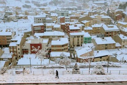
The forecast rain, combined with the low temperatures, will bring the first significant snowfall in the north of the peninsula. Up to five centimeters of snow is expected on Saturday in the north and this could reach up to 10 centimeters in high areas in the Cantabrian Mountains. Snow is forecast at elevations between 700 and 900 meters above sea level in the north, between 1,000 and 1,200 meters in the central region, and above 1,200 in the rest of the country. This could affect many regional capitals including Ávila (which is 1,131 meters above sea level, Soria (1,063 meters), Segovia (1,005 meters), Cuenca (946 meters), Teruel (915 meters), León (838 meters) and Salamanca (800 meters).
The winter-like weather will be compounded by “very cold and gusty” winds from the northeast
According to AEMET, the snow will not be as widespread as the rain, and it is likely to ease by Sunday. The weather service has issued a yellow warning, the lowest on the scale, for snow in Cantabria, León, Lleida and Asturias.
The first general frost of the season has also been forecast for the weekend. AEMET says its “reach will be notable” for October, extending to large parts of the country including the areas surrounding Cuenca, Guadalajara and Teruel. Between Sunday and Monday, many regional capitals will wake up to sub-zero temperatures, including Soria where the minimum forecast is -2ºC and León and Burgos, where the minimum will be -1ºC.
The weather is expected to slowly warm again as the week progresses, but the low temperatures could last until Wednesday. After Wednesday, Atlantic depressions “with warmer but more humid air” are expected to bring “generalized rain from the west to the east of the peninsula and Balearic Islands.”
Cold, but not a cold snap
AEMET spokesperson Rubén del Campo assured that while there will be a notable drop in temperatures, "technically is not a cold snap." A mass of Arctic air from beyond the Polar Circle could "provoke a cold snap in the winter, but not now," he added.
According to AEMET, a cold snap is defined as an episode of at least three consecutive days, where the minimum at 10% of meteorological stations are below the percentile of 5% in its series in January and February.
English version by Melissa Kitson.


