Detektia, the start-up that quietly monitors infrastructure from space
The early-warning system takes data obtained by satellites orbiting the planet to detect the risk of collapse for buildings, dams, tunnels and more. The idea was born out of the 2018 Morandi bridge tragedy in Genoa, Italy

A summer vacation changed Candela Sancho’s life. After studying physics in Madrid, getting additional training in Barcelona and Toronto and spending six years at the University of Utrecht, she traveled with friends to northern Italy in 2018. Upon returning home to Spain, she found out about the collapse on August 14 of the Ponte Morandi in Genoa, which they had crossed themselves just a few days before. Sancho wondered what had gone wrong to cause the collapse of a section of the viaduct, which killed 43 people.
With their knowledge and some help from technology, she and her friends believed they could help prevent these types of accidents in the future. It was the seed of Detektia, a start-up that uses satellite sensors and proprietary technology to measure, down to the millimeter, how the ground and the buildings that sit on it deform over time. Last year they invoiced €70,000 ($73,800) and this year they plan to double that figure after going through several incubators and maturing their product.
Two of those friends had completed a doctorate in satellite data at the Topography and Geomatics Laboratory of the Polytechnic University of Madrid. “In the end, it was about bringing that experience to the market. We were born as a spin off of the university,” explains Sancho, 41, who founded Detektia — she owns 40% — together with Alfredo Fernández, 45, who owns 30% of the company, as well as Adrián García, 32. There are also two teachers in the project: Rubén Martínez, 64, and Miguel Marchamalo, 48. They are technical profiles specialized in cartography, physics, aeronautics and forestry engineering. The company now employs six people.
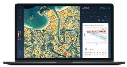
The basis for Detektia is satellite image technology, called InSAR, which measures the speed at which a surface or infrastructure moves. This data is collected by sensors that travel aboard most satellites that have orbited the Earth since the 1990s and which periodically gather data at an altitude of about 700 kilometers (434 miles). What they do is not the same as taking photographs, it is more complex. They use electromagnetic waves that are sent to Earth and bounce back, varying if something has changed location. “We can convert this gap into movement and quantify it,” says Sancho, who highlights that access to the data from some of these satellites is free — in the case of the public ones — and, in other cases, such as commercial ones, it requires payment.
The company has developed a technology to process this data based on machine learning and artificial intelligence, with which it produces situation reports, launches early warnings to avoid disasters such as Genoa, or make future predictions thanks to their own algorithms. Detektia is already working on projects in Spain, Colombia and Mexico in all phases of an infrastructure’s life: design, construction, operation and maintenance of infrastructure that includes dams, tunnels, embankments and ports.
Sign up for our weekly newsletter to get more English-language news coverage from EL PAÍS USA Edition


