The oldest network of cities in the Amazon is hiding under the Ecuadorian jungle
In 2015, laser mapping technology revealed the existence of a massive pre-Hispanic settlement in the eastern foothills of the Andes, at least 2,500 years old. Now, research published in the journal ‘Science’ provides new details.
Before modern technology confirmed it, some had long spoken of it. And in the interim, there were several discoveries that, using the tools of the time, laid the foundations for what, today, would become archaeology’s latest achievement.
We now know that a dense network of pre-Hispanic urban centers lies beneath the jungle of Ecuador’s Upano Valley, in the Amazonian province of Morona Santiago, some 235 miles southeast of Quito. There are five large settlements and 10 smaller ones, assumed to be cities, spread over an area of approximately 115 square miles, each showing signs of having been densely populated, featuring numerous residential and ceremonial structures. Dating analysis has confirmed the presence of at least five human groups, including the Kilamope and Upano cultures (between 500 BC and 300–600 AD) and then, following a period of transition, groups belonging to the Huapula culture (between 800 and 1,200 AD). Currently, the area is inhabited by the Shuar and Achuar peoples, though there is also a large presence of settlers as well.
An article published in the January issue of the journal Science presents the most recent findings on the subject. The lead author is French archaeologist Stéphen Rostain, research director at the Centre National de la Recherche Cientifique (CNRS), who has worked in the area since 1996. Among the other eight authors are Ecuadorians Fernando Mejía and Ana Freire. “The settlement were large,” Lizzie Wade writes in summary of the article, also published in Science. “The core area of Kilamope, for example, covers an area comparable in size to the pyramid-studded Giza Plateau in Egypt or the main avenue of Teotihuacan in Mexico.”
The most notable physical feature of the site, the article explains, is the complex system of roads stretching for dozens of kilometers. The towns were connected to each other by wide, straight roads, and the neighborhoods and houses by well-defined streets. Interspersed between the cities were rectangular fields of crops, and the surrounding hillsides were terraced for planting food such as maize, cassava and sweet potatoes. Contradicting the romanticized and at the same time belittling idea of a virgin, disconnected and chaotic jungle existence, the findings confirm that the pre-Hispanic inhabitants of the Amazon were remarkable builders, who significantly modified their environment and altered the morphology of the land and vegetation.
Seeing it from the sky
In 2015, Ecuador’s National Institute of Cultural Heritage (INPC, for its acronym in Spanish), directed at the time by researcher Olga Woolfson, developed the General Characteristics of the Archaeological Cultural Landscape of the Upper Upano Valley, an initiative that later became known simply as the Upano Project. Its development was funded by Ecuador’s Secretariat of Higher Education, Science, Technology and Innovation (Senecyt), a government research support institution, under then-President Rafael Correa.
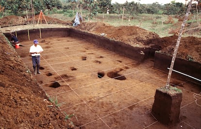
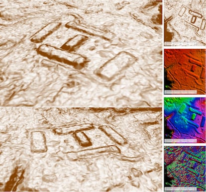
That year, a multidisciplinary team of 10 scientists from Ecuador, Spain, Russia and Argentina, together with engineers from the Military Geographic Institute (IGM), carried out the most technologically advanced phase of research on the subject to date: mapping that portion of the upper Amazon. For this purpose, they used Light Detection and Ranging technology, or Lidar, a system of laser scanning and measurement of the surface and interior of the earth deployed from the air. This was done by IGM engineers using Russian technology provided by the Ecuadorian Armed Forces.
“We were able to identify around 7,500 positive modified elements,” says Alejandra Sánchéz-Polo, a Spanish archaeologist and professor at the University of Valladolid, who participated in the research. “These were tons of earth moved by pre-Hispanic communities to form mounds that suggest stratification and social complexity. Father Pedro Porras [considered a pioneer in Amazonian research] and Ernesto Salazar [an archaeologist] had already noticed this decades earlier, but we had yet to see the extent of the structures that were there, and that formed real cities. Kunguints, for example, is a city that was not documented in published research until we did the research and published it last year.”
The publication that Sánchez-Polo is referencing is Un paisaje monumental prehispánico en la Alta Amazonía ecuatoriana: primeros resultados de la aplicación de Lidar en el valle de Upano (A monumental pre-Hispanic landscape in Ecuador’s Upper Amazon: First results of the application of Lidar in the Upano Valley). Co-authored by Sánchez-Polo and Ecuadorian researcher Rita Alvarez Litben, the study collected the first laser scanning analyses and, published in June 2023, was the first inaugural issue of Strata, an Ecuadorian journal of archaeology and paleontology that also emerged from within the INPC. “We had the opportunity to work with all that data and see the extent of the structures and, indeed, to publish it — but since we weren’t publishing in Science, it didn’t create the same stir,” Sánchez-Polo says.
The information collected using Lidar technology, which would later serve as the basis for several studies, was also slow to emerge. “The Institute and several researchers asked Senecyt for authorization to publish those findings, because there was a confidentiality clause,” explains Daniel González, Director of Knowledge Transfer at the IMPC. “At the end of 2020, Senecyt granted permission, and beginning in 2021 the Institute began to deliver the point cloud and all the reports to researchers from universities and the national and international organizations that requested them.” Among them was Stéphen Rostain.
A point cloud is a dataset used to create a three-dimensional model, making it possible to establish the shape and size of objects identified using Lidar. This is how it was possible to visualize the more than 7,500 structures, or “positive modified elements, as Sánchez-Polo described them, whose sheer size and complexity as a system, which was only partially understood, constituted a major discovery at the time. Among others, the structures included: 5,415 platforms, 1,511 truncated hills, and 260 mounds with rounded tops. The structures are square, rectangular, oval, elongated, L-shaped or formed of several levels. There are plazas, small squares, terraces, ramps, embankments, pits and ditches. The discovery of these macro-settlements changed the researchers’ image of the Upano Valley, confirming that it was a densely populated area during pre-Hispanic times, unmatched by other settlements in the Amazon.
Archeological findings
Pedro Porras was a Josephine priest born in 1915 in Ambato, in the central highlands of Ecuador. Though he had no formal education in archaeology, he is considered a pioneer in Amazonian research, and by the middle of the last century was considered an authority on the subject in Ecuador. In the 1970s, he became the Director of the Archaeological Research Center at the Pontifical Catholic University of Ecuador, and would go on to collaborate with important institutions such as the Society for American Archeology, the Società Italiana di Archeologia and the Smithsonian Institution. While knowledge of his work and respect for his reputation may vary between local and international archeological communities, his pioneering works on the Upano Valley are always the first works referenced.
Sánchez-Polo emphasizes that in 1978, thanks to excavations and more field work, Porras discovered some 200 structures in the same area of the Upano Valley, which he called the Sangay Mound Complex. He documented at least 26 assemblages formed by up to 23 symmetrically organized platforms, with central plazas and excavated linear roads linking them together, as well as possible drainage ditches that ended in ravines. In the article published in Science, Stéphen Rostain indicates that among these assemblages was one of the largest settlements: Sangay. In addition, Porras discovered that the settlements extended between the mighty Upano River and a smaller tributary called the Huapula. In 1987, he collected these findings in his famous work, Investigaciones arqueológicas a las faldas del Sangay (Archaeological Investigations in the Sangay Foothills).
But if this is the extent of past scientific mentions, there are other legacies to draw from as well. “Something that strikes me as important with respect to these recent findings is that it confirms the claims of Spanish chroniclers like Vázquez de Espinosa and Lope de Aguirre,” says the renowned Ecuadorian archaeologist Jorge Marcos. “Vázquez de Espinosa, in addition to the information he collected himself, gave an account of other studies on the Amazon from the time. For example, he talked about how the warrior groups were organized, how the dart-and-arrow spear squads were organized, and the fact that there were long cobblestone roads.”
Between the mid-sixteenth and early seventeenth centuries, the missionary Vázquez de Espinosa and the bloody conquistador Lope de Aguirre reported on some of the dynamics of life in that area of the Amazon — data that at the time went unnoticed, but that over the centuries has become of more interest as another link in the archeological chain.
The newest link
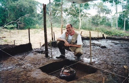
Porras died in 1990, and in 1996 a bi-national research project funded by the Government of France was launched. The project was led by Ecuadorian Ernesto Salazar and Frenchman Stéphen Rostain, who 26 years later would become the main author of the article published in Science.
Within the framework of this new research, what Father Porras had called “Sangay” was renamed Huapula, the name used by Shuar populations and other inhabitants of the area. If Lidar analysis had made it possible to document the vastness of the cities swallowed by the Amazon, the investigations of the 1990s, which lasted until 2003, constituted a deeper archeological immersion aimed at obtaining relevant clues about, for example, the habitat, the diet and the ancient volcanic activity and morphogenesis of the valley. Large-scale excavations of platforms and plazas in two major settlements uncovered domestic floors with post holes, caches, pits, hearths, large jars, grinding stones and traces of burnt seeds. All this helped to establish three major ceramic phases that correspond to different periods of habitation, and an analysis of cornstarch micro-traces revealed that they were identical to those produced today by the manufacture of the traditional “chewed” chicha, a technique used by ancestral peoples to ferment the maize-based beverage.
In recent years, other Ecuadorian researchers, such as archaeologists Estanislao Pazmiño and Alden Yépez, have conducted parallel studies on the same urban systems in the Upano Valley, but with less impact than the one published in Science. “You can’t understand the Lidar images without the field work we conducted previously,” says Stéphen Rostain. “Nowadays, the usual thing is to do the Lidar work and then go to the field to verify, but we did it the other way around, because Lidar didn’t exist at the time. Now we can better understand things that we observed in the field, but didn’t fully understand, and in turn, what helped me interpret the Lidar images is the work I had done in the field before.”
Thanks to these technological advances and decades of studies building off of each other’s findings, Rostain can now offer important conclusions about the organizational dynamics of these societies. There are no examples of egalitarian societies developing complex urban environments, he says. Rather, such societies have always been stratified and hierarchical. The perfectly straight roads, interconnected streets, and the distribution model of the platforms suggest that there were engineers and architects to design them, because such infrastructure is not created at random. Hierarchization means specialization, and just as there were engineers there must have been workers to dig and build, and while they were digging someone must have fished and cultivated and gathered food, while someone else was in charge of trade and the organization of ceremonies and rituals. The monumentality of these cities lost for centuries under the dense Ecuadoroian jungle gives us a sense of their ways of life, but, as Rostain warns, it is not possible to speak in any real detail about the true nature and scale or their organization.
Thanks to the use of the most advanced technology available, it has been possible to identify this network of impressive structures from the sky. Now, looking toward the future, archaeology will have to return to its roots: standing on the site and searching for clues in the earth.
Sign up for our weekly newsletter to get more English-language news coverage from EL PAÍS USA Edition


