Massive earthquake in Russia triggers tsunami warnings in several Pacific territories
The earthquake, measuring 8.8 on the Richter scale and with its epicenter on the Kamchatka Peninsula, has placed nations including Japan, the United States, Mexico, and Chile on alert
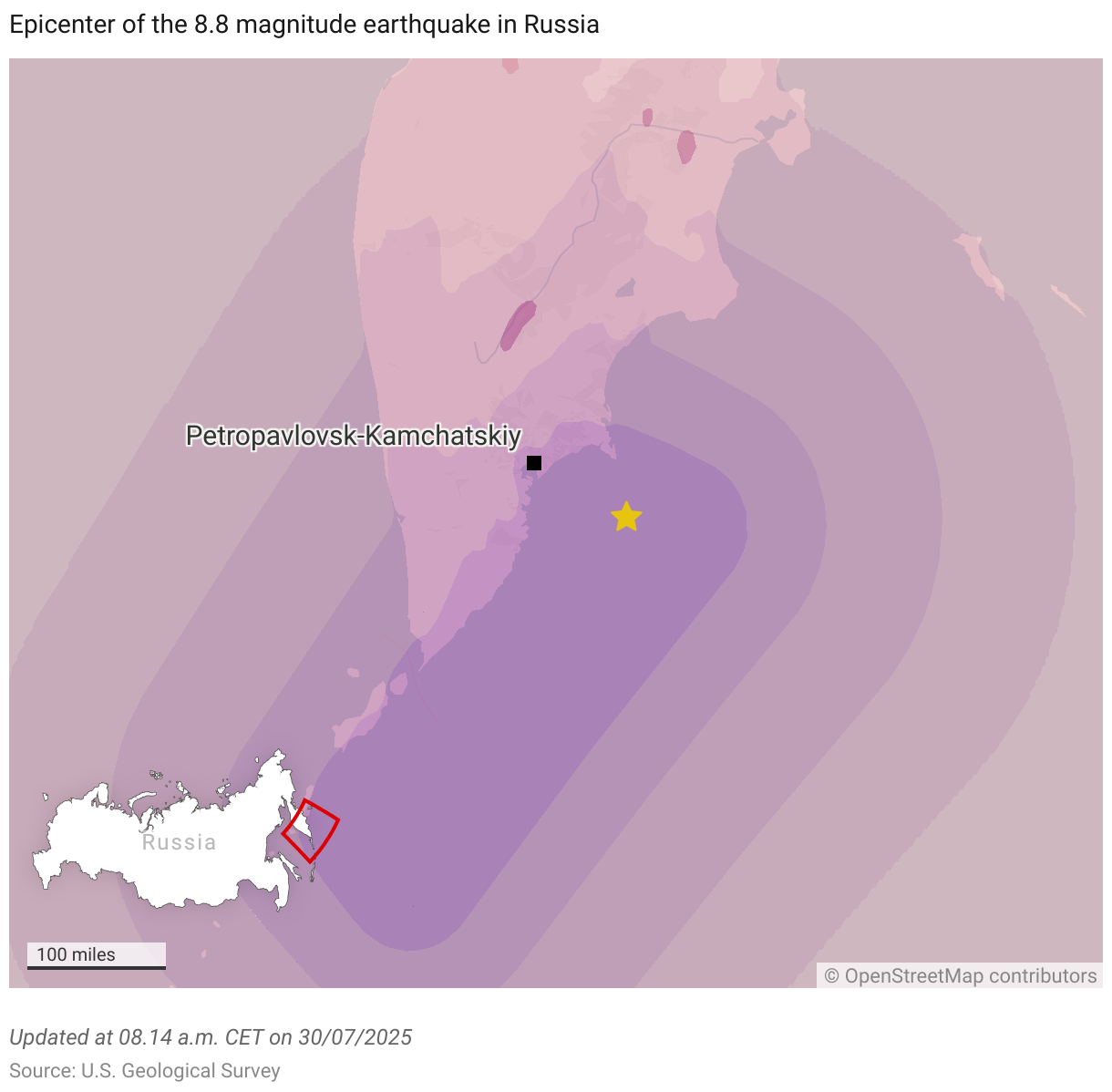
A powerful earthquake measuring 8.8 on the Richter scale struck the Kamchatka Peninsula in the far east of Russia at around 11:25 a.m. local time (1:25 a.m. CET) on Wednesday, triggering a widespread chain of tsunami warnings across the Pacific, from Japan, Taiwan, and New Zealand to U.S. territories such as Alaska and Hawaii, and South American countries including Chile, Ecuador and Peru. The quake was the strongest in the region since 1952, according to the Russian Academy of Sciences, which has established the epicenter as being about 126 kilometers (78 miles) southeast of the city of Petropavlovsk-Kamchatskiy and at a depth of 19.3 kilometers (12 miles) below the seabed.
The Pacific Tsunami Warning Center warned of waves between one and three meters above sea level in several coastal areas of Russia, Japan, Hawaii, Chile, Ecuador, and the Solomon Islands. In Russia, authorities have reported several injuries and property damage, including to a kindergarten. “Today’s earthquake was severe and the strongest in decades,” said Kamchatka Governor Vladimir Solodov in a video posted on Telegram.
Authorities in the Russian district of Severo-Kurilsk, at the southern tip of the Kamchatka Peninsula, have declared a state of emergency following the earthquake and the arrival of several tsunami waves, which reached three meters in height, according to the Russian news agency RIA Novosti. According to state media, the strong waves tore boats from their moorings and swept away storage containers, forcing the evacuation of about 300 people from the port.
On the Russian island of Sakhalin — just 25 miles from Japan’s Hokkaido — authorities have cut off power after detecting damage to the grid caused by the earthquake, according to RIA. Also, the northern part of the Kuril Islands, which are administered by Sakhalin, is in a state of emergency. Images broadcast by the media show waves flooding a port, although authorities say all residents have been evacuated to safe areas.
Alert in Asia
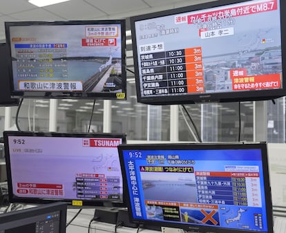
Despite its magnitude, the earthquake was barely felt in Japan, the nation closest to the epicenter. There, it only reached level two on Japan’s seven-level seismic scale, which measures the intensity of the tremor on the surface and its destructive potential. However, Japan immediately activated its emergency system and issued evacuation orders for more than 1.9 million residents in 21 prefectures. Waves of more than half a meter have already been recorded in several locations in northeastern Japan, and the national Meteorological Agency has warned that they could reach three meters throughout the day.
The Japanese company TEPCO has ordered the evacuation of all workers from the Fukushima Daiichi nuclear power plant as a precaution, even though “no anomalies have been detected” at the facility. The plant, located in northeastern Japan, suffered a core meltdown in 2011 after being hit by a tsunami and is currently being decommissioned. The release of treated water into the ocean has also been temporarily suspended.
China, the Philippines, Indonesia, and Taiwan have also issued tsunami warnings, and emergency services are monitoring the situation. The danger of a tsunami does not depend solely on the height of the waves, but also on the energy with which they strike and the length of time they do so.
This type of phenomenon can cause strong currents, abnormal or sudden tidal movements, and repeated waves lasting several hours that are capable of sweeping away boats or people, and which are especially dangerous in ports and river mouths.


State of emergency in Hawaii
In the United States, the National Weather Service (NWS) raised the tsunami warning to the highest level for the entire state of Hawaii, located in the middle of the Pacific Ocean, as well as for the Aleutian Islands, which belong to Alaska and are inhabited by some 5,000 people. In addition, it issued a yellow warning for the entire west coast of the United States and Canada, which it later raised to orange, the second level on the three-color intensity scale.
Alaska, the northernmost state in the United States, is already beginning to feel the arrival of the tsunami. According to local media and others such as CNN, its effects are already being felt in the form of small waves. The region was hit by a tsunami in 1958, in Lituya Bay, which caused a mega-wave of immense size, 524 meters high.
Hawaiian authorities have ordered the “immediate evacuation” of large parts of the island of Oahu, including the state capital, Honolulu. Authorities have warned residents via social media that waves, about four feet (1.22 meters) high, have already hit their shores. “Stay out of evacuation areas,” they urged. The water has hit the north coast of Oahu, where Honolulu is located.
Shelters have been set up on the various islands, the locations of which are announced from time to time on local news programs: schools, hotels, and community centers are taking in residents and inhabitants. Many of them have very little water or food, so they recommend that those who are going to stay there bring as much as they can.
Hawaii Governor Josh Green declared a state of emergency and called on the population to evacuate coastal areas. “I have signed an emergency proclamation, and both the State and County Emergency Operations Centers are fully activated. Please take this situation seriously,” Green said on social media. “This is the most serious warning you can get. It is not a watch warning.”
“Stay home and watch television,” Green insisted later at a press conference. “Everything is fine, we haven’t seen any big waves, but when the water recedes, it means the sea is active, so let’s keep our fingers crossed that it doesn’t get any worse,” he said. All commercial ports have been closed and evacuated. There are also no planes flying in or out of the islands.
The key time in Hawaii was 7:10 p.m. (7:10 a.m. on Wednesday CET), when the first wave of the tsunami was expected to hit. Meteorologists and experts say that sea conditions will not be critical and that the water will reach a height of approximately one meter. However, they predict that the phenomenon will surround the islands and that the water will come in with great force. Waves of that size have the capacity to move people or vehicles.
Anticipation in the United States is high. All U.S. news programs are connecting live with the islands, some even linking directly to their local networks’ programming. Cameras are focused on the coasts of the westernmost islands, such as northern Kauai, especially Hanalei Bay, and Oahu, where local television stations and webcams have already shown the sea receding slightly.
Alerts in Mexico, Chile, Peru, and Ecuador
In Mexico, the Tsunami Warning Center of the Secretariat of the Navy (Semar) issued an alert for the Pacific coast, warning of the arrival of waves less than 20 centimeters high starting at 2:00 a.m. on Wednesday local time. It also recommended “keeping the population away from the beaches” until the alert was canceled and warned that “strong currents are expected at the entrance to ports.”
Chilean President Gabriel Boric announced on his social media account that the tsunami warning would remain in effect along the entire Chilean coast on Wednesday. “The protocol is to evacuate three hours before the estimated arrival of the wave. We will be providing detailed information on the steps to follow. Remain calm and follow the instructions of the authorities,” he said in a message on social media.
In Ecuador, the Navy’s Oceanographic and Antarctic Institute has also warned of the possibility of a tsunami and has recommended the suspension of coastal maritime activities. In its statements, it explained that the effects of the earthquake in Russia could result in waves of 1.4 meters arriving on Wednesday. “As for the continental coastal area, the observation status remains in place, as the risk of impact is considered to be lower at this time,” it added.
The Hydrography and Navigation Directorate of the Peruvian Navy has also issued a tsunami warning, although no further information has been provided at this time.
Sign up for our weekly newsletter to get more English-language news coverage from EL PAÍS USA Edition


