Deadly Texas floods point to the ‘new perfect storm’ of climate change
Moist air masses fed the heavy rainfall as they moved into the so-called ‘Flash Flood Alley.’ For every 1°F increase in temperature, there is about 4% more water vapor in the atmosphere
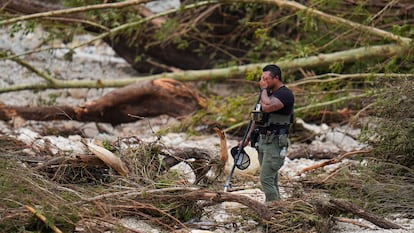

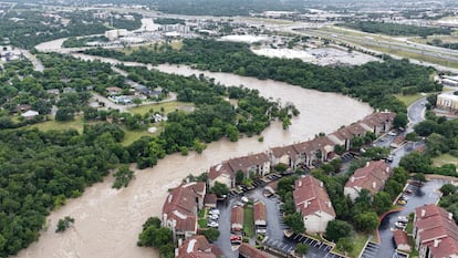
The state of Texas, in the United States, is marked by a climate that constantly tests the limits. It experiences both droughts and deep deluges, hurricanes and snowstorms. But what happened on the night of July 4 in Kerr County went far beyond that. The rains were so torrential that water flow surged from two cubic meters per second to 4,700, and the Guadalupe River — which originates in Kerr and empties into San Antonio Bay — rose from a depth of one meter to nearly 10 in just 90 minutes, a level it hadn’t reached since 1987. It was simply too much rain falling over a very small area. And in a very short time, the floods killed over 100 people.
Amid the climate crisis and Donald Trump’s presidency, marked by skepticism toward climate science, there is one logical question: to what extent did global warming play a role in this extreme event? And while what scientists call attribution studies are needed to provide a definitive answer, there are clear signs pointing to the idea that the disproportionate downpour resulted from a cocktail of factors — including Texas’s topography and temporary weather conditions — fueled, precisely, by the rising temperature of the Earth.
Flash Flood Alley
Hill Country, the Texas region where the river swelled, has a nickname that serves as a kind of warning: Flash Flood Alley. Its topography — a mix of coastal plains and rugged hills — creates two ideal conditions for flash flooding: winds get trapped and rise in elevation, and rainwater rushes quickly down the slopes.
On July 4, several other factors came into play, as explained in a press briefing by Shel Winkley, a climate and weather specialist at Climate Central. First, there was leftover moisture from Tropical Storm Barry, which passed through Texas in late June. Added to this was additional low-level atmospheric moisture from the Gulf of Mexico — warmer than usual — which collided with cold air moving down from the Texas plains.
That clash of air masses, says Dr. Rafael Méndez Tejeda, a professor at the University of Puerto Rico at Carolina, leads to evaporation and, ultimately, intense rainfall. “It’s similar to what happens with glasses when you go from a cold place to a warm one — they fog up,” he explains. He adds that the storm clouds involved are vertical in nature: tall in height but narrow at the base. This means that all the energy built up over as much as 12 kilometers (7.4 miles) of altitude is released as rain over a very small area — sometimes no more than five kilometers (3.1 miles) wide.
To make matters worse, scientists point out, Texas had just gone through weeks of drought. As a result, the hardened ground was unable to absorb the sudden deluge in such a short time.
And what about climate change?
Dr. Friederike Otto, co-founder of World Weather Attribution (WWA), says that “extreme downpours like these are exactly what science expects in a rapidly warming world driven by the burning of fossil fuels.”
For example, it’s estimated that for every 1°F (0.56°C) rise in temperature, there is about 4% more water vapor in the atmosphere — which leads to a more heavily loaded hydrological cycle and increases the likelihood of extreme rainfall events.
In San Antonio, just over 100 kilometers (62 miles) from Kerr County, rainfall intensity has already increased by 6% since 1970, according to NOAA data. In San Angelo — more than 200 kilometers (124 miles) northwest of the county and also hit hard by the torrential rains — the increase has been as high as 29%.
In fact, a study published in Nature in 2022 found that if the world continues on its current climate trajectory without taking action, Texas is among the states projected to see the highest increase in average annual flood losses by 2050 — with a rise of more than 900%.
In a rapid-response effort to explore the connection between climate change and the recent rains in Texas, the organization Climate Meter concluded that when comparing regional weather conditions from 1950 to 1986 to those from 1987 to 2023, the current climate is up to 7% more humid. That alone is a major clue.
The second factor, Winkley emphasizes, is the warm moisture coming from the Gulf of Mexico. “Those temperatures are between 1 and 2°F [0.56 to 1.11°C] above the average for this time of year,” he explains. “And using attribution science, we know that unusually warm temperatures like these are now 10 to 30 times more likely because of global warming.”
At this point, every extreme weather event is unfolding against the backdrop of a drastic rise in the global average temperature — and nearly all of Earth’s natural systems are shifting as a result. This is precisely the moment when gathering more data is not just timely, but essential.
“What worries me most,” says Méndez, “is that U.S. offices and agencies working on this are being weakened — and that won’t just affect the United States, but all of Latin America as well.”
Another key moment to measure the impact, he notes, will come in September, when the Atlantic hurricane season reaches its peak.
Sign up for our weekly newsletter to get more English-language news coverage from EL PAÍS USA Edition


