Tropical Storm Edouard is moving toward Texas and Louisiana, bringing a risk of heavy rain and flooding
The storm could intensify before making landfall and bring up to 23 centimeters of rain to some areas
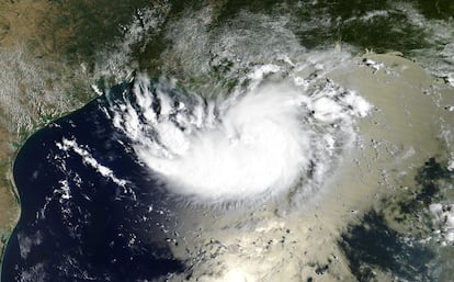

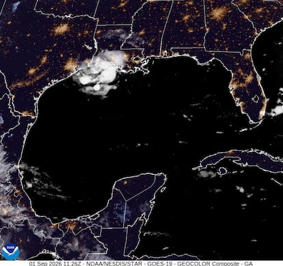
After weeks of extreme heat and drought, the relief that some areas of Texas have been waiting for will come accompanied by a new threat: Tropical Storm Edouard is moving toward the Gulf Coast on Tuesday, bringing rains capable of causing flash floods and likely to strengthen before making landfall.
The system intensified Monday night, upgrading from a tropical depression to a tropical storm, and by Tuesday morning, it was near the Texas-Louisiana border. Its maximum sustained winds reached 65 kilometers per hour (40 miles per hour) as it moved west-northwest at 13 kilometers per hour (eight miles per hour).
Forecasts indicate that Edouard could strengthen significantly and possibly reach hurricane strength before making landfall in Texas. However, it is expected to begin weakening once it moves inland. The main danger, according to authorities, would not necessarily be the winds, but rather torrential rains and flooding.
The National Hurricane Center has issued tropical storm warnings, hurricane watches, storm surge advisories, and flood alerts for parts of the western Gulf Coast.
The Texas coast and parts of the state’s central-eastern region could receive between eight and 15 centimeters (three and six inches) of rain, while some areas could see up to 23 centimeters (nine inches). Lower amounts are expected in southwestern Louisiana.
The risk of flash flooding is increasing due to the intensity of the expected rainfall. The heaviest rain bands could produce between 7.6 and 10.2 centimeters of rain per hour (three to four inches), particularly affecting low-lying and urban areas.
Texas Governor Greg Abbott noted that flooding is the biggest problem expected from the storm and urged residents to prioritize their safety and stay away from rising waters.
Edouard is hitting a region that has been experiencing exceptionally dry conditions and extreme temperatures for several weeks. In North Texas, much of the region had gone 47 days without measurable rain. Last month tied for the second-driest August on record in the area, following a month that included 27 days with temperatures above 37.8 degrees Celsius (100 degrees Fahrenheit) and 11 consecutive days of triple-digit heat.
The arrival of moisture and rain will break that streak and bring temperatures down to around 32.2 degrees (90 degrees Fahrenheit) on Wednesday and Thursday. Scattered showers and isolated thunderstorms are also expected, some accompanied by lightning.
However, the relief will be temporary. Forecasts indicate that the humidity will subside before the holiday weekend, when dry conditions and higher temperatures are expected to return.
The threat of heavy rain led several school districts in Southeast Texas to cancel classes on Tuesday to prevent students, staff, and families from having to travel during the worst of the weather. Some schools chose to adjust their schedules.
Where will it rain the most?
Rainfall will be very unevenly distributed across Texas. In the southeast, the Houston and Bryan areas could see between 7.6 and 15.2 centimeters (three and six inches), with isolated amounts of up to 22.9 centimeters (nine inches).
South and east of Dallas-Fort Worth, towns such as Mexia and Fairfield could see up to 7.6 centimeters (three inches) of rain. In the Dallas-Fort Worth metropolitan area, less than 2.54 centimeters (one inch) is generally expected, while in the northwest part of the region, some areas could receive only a minimal amount or remain dry due to the system’s rapid weakening. This variation also means that not all regions will experience the same relief from the drought.
However, the storm will also have a mixed effect on the wildfires affecting the region. The increase in humidity will help emergency crews over the next few days, but the gusts of up to 32 kilometers per hour (20 miles per hour) forecast for Wednesday could complicate containment efforts.
Sign up for our weekly newsletter to get more English-language news coverage from EL PAÍS USA Edition