This is what Hurricane Milton’s reverse storm surge looks like: ‘No water as far as I can see’
Authorities warn that the phenomenon, which occurs when winds blow out to sea in the middle of a storm, poses ‘a life-threatening risk’
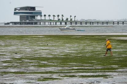
Amid the fascination on social media over the receding water in Tampa Bay due to the power of Hurricane Milton’s winds, the Florida Division of Emergency Management has launched an alert on its X account to try to dissuade people from visiting the area. “Do not walk out into receding water in Tampa Bay — the water WILL return through storm surge and poses a life-threatening risk,” it said in a post just after 9 p.m. local time.
The phenomenon is known as a reverse or negative storm surge and it occurs when the winds of a storm blow towards the sea instead of towards land. A 2023 study published in the journal Ocean Modelling states that reverse surges appear to be less dangerous than normal surges, but they pose a risk to coastal ecosystems and boats due to sudden and unexpected drops in water levels, but also to the population, in case someone decides to walk on the exposed muddy seabed.
News Nation correspondent Brian Entin shared a video on his X account showing what was happening. Accompanied by a cameraman and standing on Bayshore Boulevard in Tampa Bay, he said that Milton was sucking up water, something they already suspected would happen. “Our light isn’t bright enough to see how far it goes, but I don’t see any water as far as I can see,” he explained.
The water has been sucked out of Tampa Bay by Milton.
— Brian Entin (@BrianEntin) October 10, 2024
Happened fast. pic.twitter.com/8ghtF5SZYx
In the case of Hurricane Ian, in 2022, the meteorologist Ernie Jillson told USA Today that reverse surge depends on the shape of the waterway and that “bays are more susceptible because they’re like a bowl of water. They’re protected by land on all sides except one, which is why they’re so susceptible to being emptied out.”
In its 11 p.m. update, the National Hurricane Center reported that Milton, which made landfall as a Category 3 storm around 8:30 p.m. in Sarasota County, is moving inland at about 16 mph (26 km/h), and its center will continue to track across the central Florida peninsula through the rest of the night, before emerging off the east coast of Florida on Thursday.
Although its power has diminished, Milton still poses a threat to affected communities, with maximum sustained winds of around 102 mph (165 km/h) with higher gusts extending up to 35 miles (55 km) from the center. Rainfall amounts of eight to 14 inches, and even up to 18 inches (45 cm) in some locations are expected through Thursday in central and northern parts of the peninsula, as well as dangerous storm surge.
Sign up for our weekly newsletter to get more English-language news coverage from EL PAÍS USA Edition


