Hurricane Lee barrels through open Atlantic waters after becoming season’s first Category 5 storm
It is not expected to make landfall, but meteorologists warned it would generate dangerous waves of up to 15 feet (5 meters) across the northern coast of Puerto Rico and other nearby islands

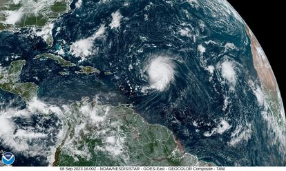
Hurricane Lee charged through warm Atlantic waters on Friday and threatened to unleash heavy swells across the northeast Caribbean. It became the season’s first Category 5 storm before weakening slightly.
Currently a Category 4 hurricane, it is not expected to make landfall, but meteorologists warned it would generate dangerous waves of up to 15 feet (5 meters) across the northern coast of Puerto Rico and other nearby islands. While Lee is on a path that would take it a couple of hundred miles (kilometers) northeast of the Caribbean, tropical storm conditions are not forecast for the region.
“Although the hurricane is incredibly powerful, its wind field is not particularly large,” the National Hurricane Center said.
The hurricane was located about 565 miles (910 kilometers) east of the northern Leeward Islands. It had winds of up to 155 miles per hour (250 kilometers per hour) and was moving west-northwest at 13 mph (20 kph).
“Fluctuations in intensity like what has occurred this morning are not uncommon in intense hurricanes,” the center said.
Lee is expected to strengthen and reach winds of up to 180 mph (290 kph). Only seven Atlantic hurricanes have had winds of that magnitude since 1966, according to Colorado State University hurricane researcher Phil Klotzbach. Among those was Hurricane Dorian, which pummeled the northern Bahamas in 2019 as a Category 5 storm, hovering over small islands for about two days.
Hurricane Lee strengthened from a Category 1 storm to a Category 5 storm in less than 24 hours, said Lee Ingles, a forecaster with the National Weather Service in San Juan. She said warm waters and a lack of wind shear contributed to the rapid intensification.
“The hurricane had all the ingredients to become a powerful storm in such a short amount of time,” she said.
Ingles warned that climate change will lead to more rapidly intensifying storms in upcoming years.
The hurricane center said dangerous surf and deadly rip currents would likely hit the northern Leeward Islands later Friday. They would spread to Puerto Rico, Hispaniola, the Turks and Caicos, the Bahamas and Bermuda over the weekend.
“We will see waves between 10 and 15 feet (3 and 5 meters), so we don’t want anyone on the beaches,” said Ernesto Morales with the National Weather Service in San Juan, Puerto Rico.
The National Hurricane Center said dangerous surf and rip currents were forecast for most of the U.S. East Coast starting Sunday, but that it did not have further details of what else the storm might unleash.
“It is way too soon to know what level of impacts, if any, Lee might have along the U.S. East Coast, Atlantic Canada or Bermuda late next week,” the center said.
U.S. President Joe Biden on Thursday was given the hurricane’s latest trajectory and details of preparations underway by the U.S. Federal Emergency Management Agency. About 4.5 million meals and nearly 8.9 million liters of water are available in Puerto Rico, and another roughly 250,000 meals and more than 600,000 liters of water in the U.S. Virgin Islands, the agency said Friday.
FEMA said it has also deployed rapid response teams to both U.S. territories as a precaution.
Lee is the 12th named storm of the Atlantic hurricane season, which runs from June 1 to Nov. 30 and peaks in September.
Tropical Storm Margot became the 13th named storm after forming on Thursday evening. It was located about 580 miles (930 kilometers) west-northwest of the Cabo Verde Islands. It had winds of up to 40 mph (65 kph) and was forecast to strengthen into a hurricane over the weekend. It was moving west-northwest at 17 mph (28 kph) and is expected to remain over open water.
The National Ocean and Atmospheric Administration in August forecasted between 14 and 21 named storms this season, with six to 11 of them expected to become hurricanes, and of those, two to five possibly developing into major hurricanes.
In the Pacific, Hurricane Jova churned through open waters far from Mexico’s southwest coast and posed no threat to land.
It was located about 755 miles (1,220 kilometers) west-southwest of the southern tip of Baja, California, and was moving west-northwest at 16 mph (26 kph) with winds up to 100 mph (155 kph).
Sign up for our weekly newsletter to get more English-language news coverage from EL PAÍS USA Edition
Tu suscripción se está usando en otro dispositivo
¿Quieres añadir otro usuario a tu suscripción?
Si continúas leyendo en este dispositivo, no se podrá leer en el otro.
FlechaTu suscripción se está usando en otro dispositivo y solo puedes acceder a EL PAÍS desde un dispositivo a la vez.
Si quieres compartir tu cuenta, cambia tu suscripción a la modalidad Premium, así podrás añadir otro usuario. Cada uno accederá con su propia cuenta de email, lo que os permitirá personalizar vuestra experiencia en EL PAÍS.
¿Tienes una suscripción de empresa? Accede aquí para contratar más cuentas.
En el caso de no saber quién está usando tu cuenta, te recomendamos cambiar tu contraseña aquí.
Si decides continuar compartiendo tu cuenta, este mensaje se mostrará en tu dispositivo y en el de la otra persona que está usando tu cuenta de forma indefinida, afectando a tu experiencia de lectura. Puedes consultar aquí los términos y condiciones de la suscripción digital.


