The countdown to save Utah’s Great Salt Lake
Abusive irrigation, an increasing population and climate change are drying up the largest lake of its kind in the Western Hemisphere. In November 2022, it fell to its lowest level in history

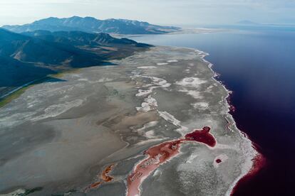
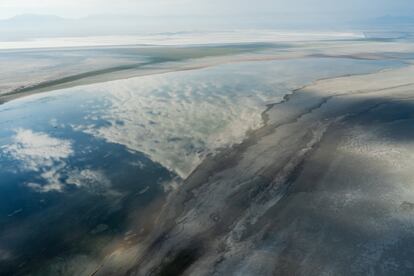
Before, all of this was water.
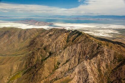
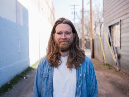
Biologist Bonnie Baxter points in the distance, to where the southern shores of Utah’s Great Salt Lake used to reach. It is the largest saltwater lake in the Western Hemisphere and the eight-largest in the world.
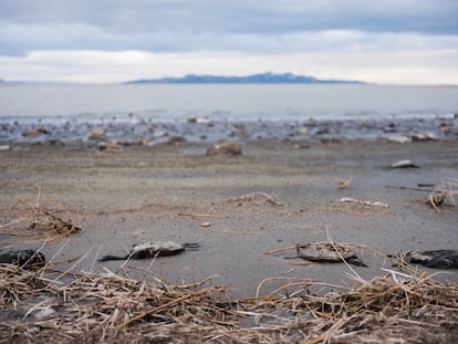
In mid-March, you can see sand, mud and dead birds. Where a famous resort from the early-20th century once stood – before it was engulfed in flames – stands a sad imitation: an abandoned building that now serves as a symbol of a unique ecosystem’s decline.
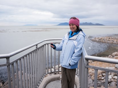
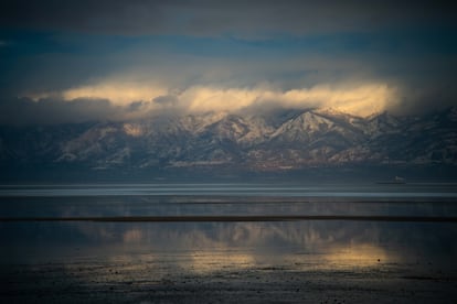
Baxter is surrounded by the majestic 12,000-foot-high snow-capped mountains of the Wasatch Range. And, amidst this majestic vista, you can almost hear the tick-tock of an environmental time bomb.
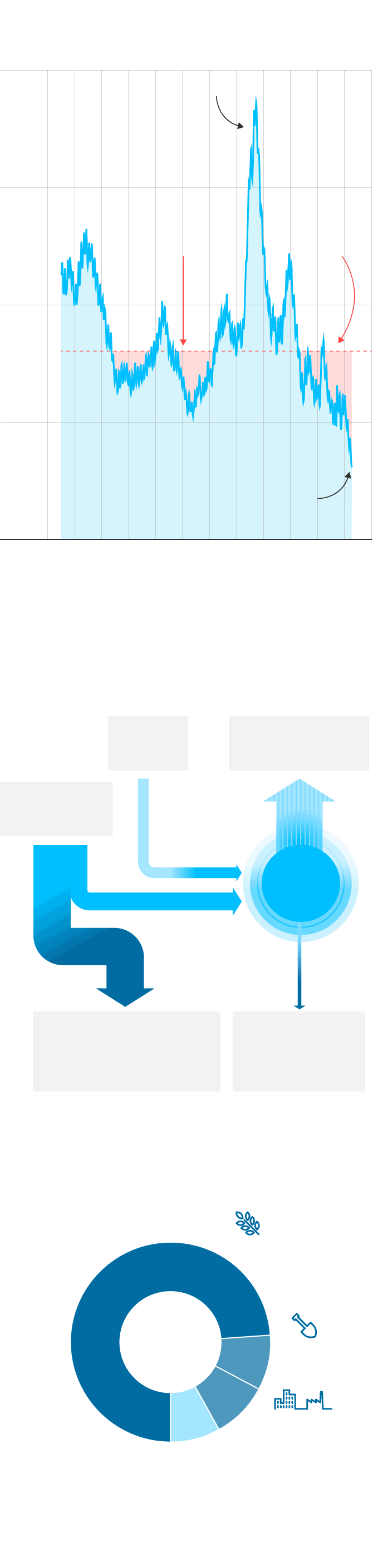
The lake has lost 73% of its water and 60% of its surface area, as a result of agricultural irrigation that is incompatible with the mega-drought that has plagued the Western United States for nearly two decades. The effects of climate change and population pressure from neighboring Salt Lake City – which has 1.2 million residents, a number expected to double by 2050 – are also contributing to the collapse of the ecosystem.
Last November, a record low of 4,188 feet above sea level was recorded.
“It’s amazing how quickly the situation has worsened in the last two years. It’s like being on a cliff,” says Baxter, who has studied lake microorganisms for a quarter-of-a-century and is director of the Great Salt Lake Institute at Westminster College.
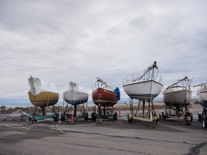
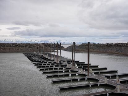
Behind her, the small marina looks more like a large puddle without boats. The last ones – fruitlessly waiting for better times on dry land – were removed last year. It is one of the most impactful images of a crisis that is worrying dozens of Utah scientists, environmental activists, community leaders and politicians.
The lake has managed to capture global attention, thanks in part to a grim report published in January of 2023 by Utah’s Brigham Young University (BYU). It was authored by 32 scientists and conservationists, led by ecologist and hydrologist Ben Abbott. In the report, they warn that, if the current trend doesn’t change, the lake could dry up completely within five years.


“It’s difficult to describe the consequences of something like this without sounding exaggerated. But if we lose [the lake], we will face the end of our way of life in the region,” Abbott affirms. “Temperature changes will be extreme. Desertification and pollution will increase… industry and agriculture will collapse.”
“It will also have effects on climate change. The disappearance of these saline lakes contributes to the rise of the sea-level. The water we lose in these basins doesn’t just disappear… it evaporates and ends up in the ocean. It’s just another global implication of a problem that goes well beyond Utah. The drying out of these systems is one of the biggest challenges we face as a species.”
The report sets economic losses at $2.5 billion a year. The loss of the lake will affect factories that extract minerals such as magnesium, or potassium sulfate, which is used for fertilizer. The flourishing ski tourism industry will also be hit, as will the mild winter temperatures: when cold air comes into contact with water from the lake, the winter climate becomes less harsh.
Utah’s Great Salt Lake, on track
to disappear in five years
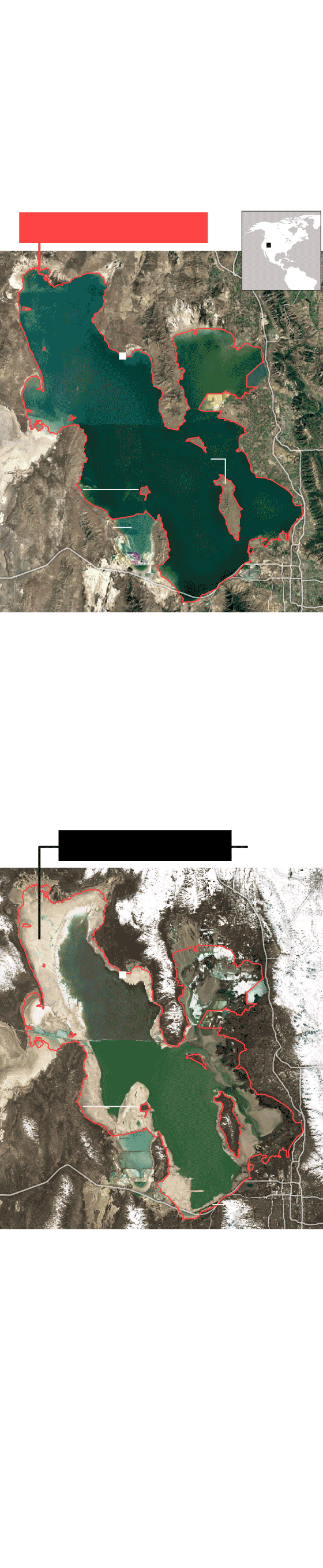
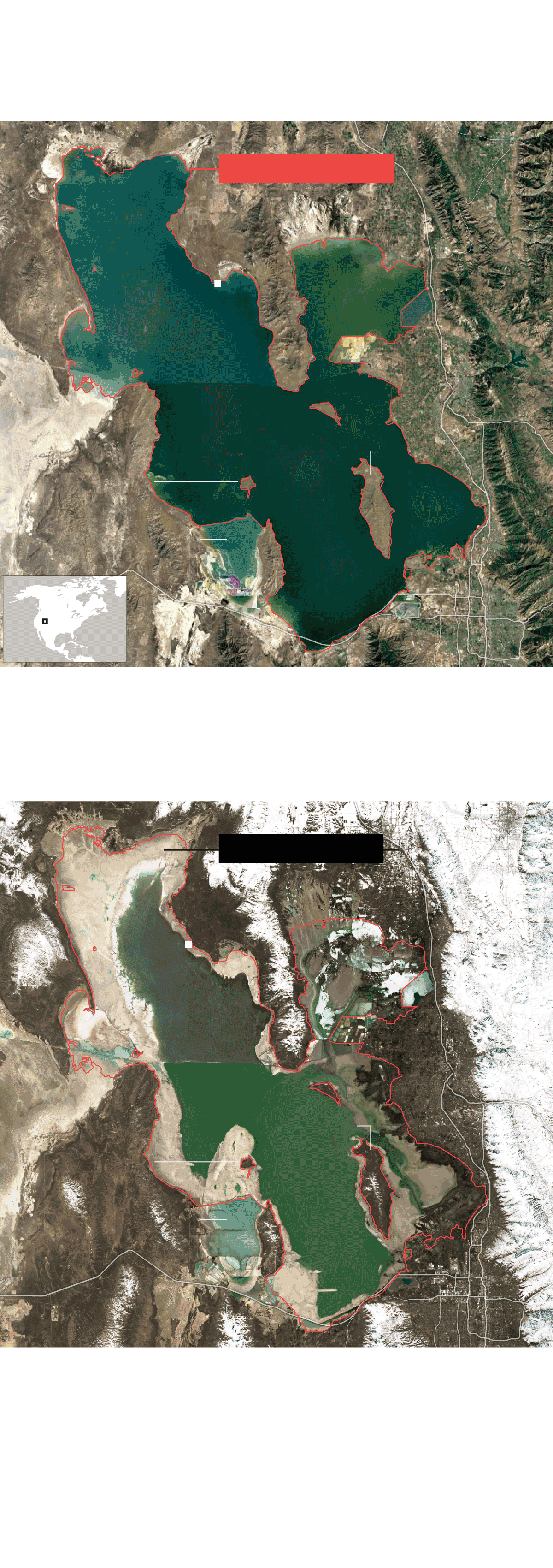
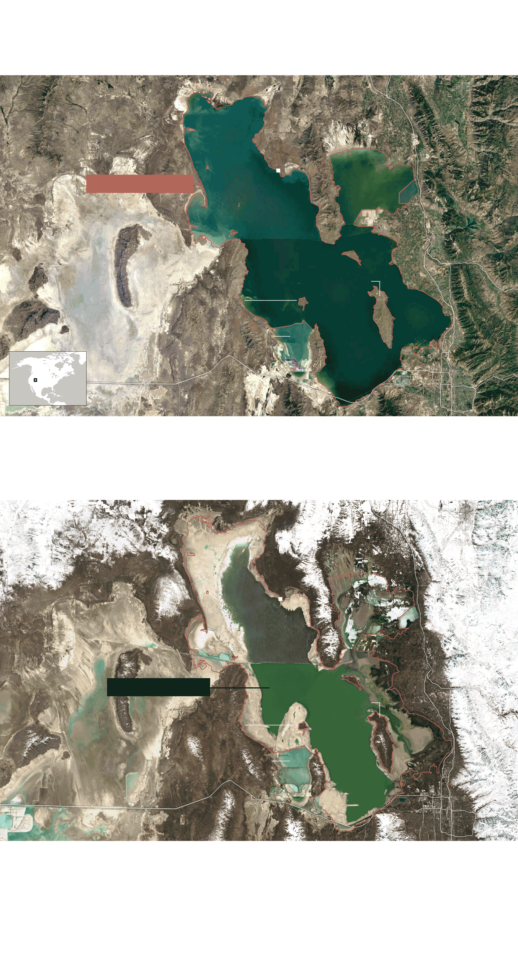
This photograph taken by the Landsat-5 satellite in December 1985 is an example of the average area occupied by the Great Salt Lake. The water level is at 1,282 meters elevation, the 166-year average (1850 and 2016).
Average surface area
U. S.
Spiral
Jetty
Brigham City
North Arm
Great
Salt Lake
Ogden
Antelope Island
20 km
Layton
South Arm
Mining
evaporation
ponds
Salt Lake
City
This other ESA image shows a very different picture. On November 21, 2022, the water had dropped to a historic low of 1,277 meters. The lake had lost 60% of its usual water surface.
November 21, 2022
Spiral
Jetty
Brigham City
Great
Salt Lake
Ogden
20 km
Layton
Salt Lake
City
The difference in hue between the north and south of the lake is a consequence of the obstruction caused by the railroad embankment erected by the Southern Pacific Company in 1959. In 2016, a 55-meter bridge was built to make both areas more connected, but its effects still continue. The areas in white correspond to the territories covered with snow.
Source: Tarboton, D. (2017). Great Salt Lake Bathymetry, www.hydroshare.org; ESA and USGS. NACHO CATALÁN / EL PAÍS

Utah’s Great Salt Lake, on track
to disappear in five years
This photograph taken by the Landsat-5 satellite in December 1985 is an example of the average area occupied by the Great Salt Lake. The water level is at 1,282 meters elevation, the 166-year average (1850 and 2016).
Average surface area
U. S.
Spiral
Jetty
Brigham City
North Arm
Great
Salt Lake
Ogden
Antelope Island
20 km
Layton
South Arm
Mining
evaporation
ponds
Salt Lake
City
This other ESA image shows a very different picture. On November 21, 2022, the water had dropped to a historic low of 1,277 meters. The lake had lost 60% of its usual water surface.
November 21, 2022
Spiral
Jetty
Brigham City
Great
Salt Lake
Ogden
20 km
Layton
Salt Lake
City
The difference in hue between the north and south of the lake is a consequence of the obstruction caused by the railroad embankment erected by the Southern Pacific Company in 1959. In 2016, a 55-meter bridge was built to make both areas more connected, but its effects still continue. The areas in white correspond to the territories covered with snow.
Source: Tarboton, D. (2017). Great Salt Lake Bathymetry, www.hydroshare.org; ESA and USGS. NACHO CATALÁN / EL PAÍS
Utah’s Great Salt Lake, on track to disappear in five years
This photograph taken by the Landsat-5 satellite in December 1985 is an example of the average area occupied by the Great Salt Lake. The water level is at 1,282 meters elevation, the 166-year average (1850 and 2016).
Logan
Average surface area
Spiral
Jetty
Brigham City
North Arm
Great
Salt Lake
Ogden
Antelope Island
20 km
Layton
South Arm
Mining evaporation ponds
Salt Lake
City
U. S.
This other ESA image shows a very different picture. On November 21, 2022, the water had dropped to a historic low of 1,277 meters. The lake had lost 60% of its usual water surface.
Logan
November 21, 2022
Spiral
Jetty
Brigham City
North Arm
Great
Salt Lake
Ogden
Antelope Island
20 km
Layton
South Arm
Mining evaporation ponds
Salt Lake
City
The difference in hue between the north and south of the lake is a consequence of the obstruction caused by the railroad embankment erected by the Southern Pacific Company in 1959. In 2016, a 55-meter bridge was built to make both areas more connected, but its effects still continue. The areas in white correspond to the territories covered with snow.
Source: Tarboton, D. (2017). Great Salt Lake Bathymetry, www.hydroshare.org; ESA and USGS. NACHO CATALÁN / EL PAÍS
Utah’s Great Salt Lake, on track to disappear in five years
This photograph taken by the Landsat-5 satellite in December 1985 is an example of the average area occupied by the Great Salt Lake. The water level is at 1,282 meters elevation, the 166-year average (1850 and 2016).
Logan
Spiral
Jetty
Brigham City
North Arm
Average surface area
Great
Salt Lake
Ogden
Antelope Island
20 km
Layton
South Arm
Mining evaporation ponds
Salt Lake
City
U. S.
This other ESA image shows a very different picture. On November 21, 2022, the water had dropped to a historic low of 1,277 meters. The lake had lost 60% of its usual water surface.
Logan
Spiral
Jetty
Brigham City
North Arm
Great
Salt Lake
Ogden
November 21, 2022
Antelope Island
20 km
Layton
South Arm
Mining evaporation ponds
Salt Lake
City
The difference in hue between the north and south of the lake is a consequence of the obstruction caused by the railroad embankment erected by the Southern Pacific Company in 1959. In 2016, a 55-meter bridge was built to make both areas more connected, but its effects still continue. The areas in white correspond to the territories covered with snow.
Source: Tarboton, D. (2017). Great Salt Lake Bathymetry, www.hydroshare.org; ESA and USGS. NACHO CATALÁN / EL PAÍS
The point in the report that caused the most concern was about the toxins that have accumulated in the vast lake bed. These toxins include natural arsenic from the mountains – which already exceeds recommended levels – mercury produced by gold mining in the region, or the selenium provided by the neighboring Rio Tinto Kennecott copper mine. The chimney of its refinery dominates the view from the southern end.
If the worst omens come true, the lake bed will end up turning into a dust bowl, in the style of the one that pushed the characters in John Steinbeck’s The Grapes of Wrath to migrate. The wind will drag these poisonous clouds into the lungs of the 2.6 million residents of its banks – representing 80% of Utah’s population – which will increase, according to the report, “the rates of chronic and acute diseases associated with pollution, including sexual dysfunction, congenital diseases, cognitive lesions, cardiovascular conditions, and cancer. “The list of hazardous materials down there is as long as my arm,” Abbott notes.
“Everything that is deposited in [the Great Salt Lake] remains. The only thing that always goes away is the water,” says Baxter.
The salt also stays. “With less water, the ecosystem becomes increasingly salty,” the biologist adds. Even if the worst scenario is avoided, the survival of shore flies and brine shrimp will be in danger. These microorganisms dominate the area’s life, making it an obligatory stop for some 10 million migratory birds that hail from 338 species. They take the North American Pacific Route each year, in a north-south migration.
“If they lose this waypoint, they will lose one of the few remaining refuelling spots in the Western Hemisphere. They will be forced to travel for too long,” Baxter warns.

With her team, Baxter is dedicated to the study of flies and brine shrimp. On the ground, they take samples that are later examined in a laboratory at Westminster College, located in Salt Lake City.
“The ocean [is] 3.5% salt. This fall, the lake registered a dangerous 19%... and we know that anything above 12% is not good for these microorganisms.”
Utah’s brine shrimp keeper is a big man named John Luft, who trucks up and down the riverbanks. He works in the State Division of Wildlife Resources, supervising the activity of companies dedicated to the cultivation of those tiny shrimp, which are unfit for human consumption and are instead fed to prawns. Between 40 and 50% of global production originates from the Great Salt Lake and is shipped off to the Asian or Latin American markets.
“My mission is to control the population. [I make sure that] once the business end of things is taken care of, there’s always enough food left for the birds,” Luft explains.”
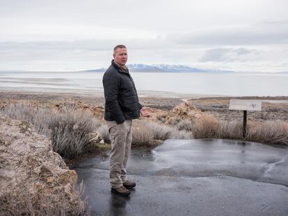
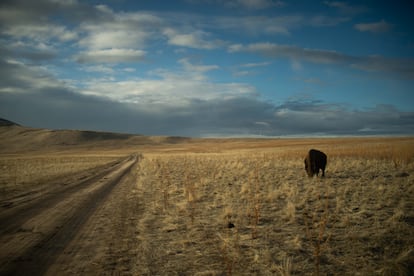
From the Antelope Island State Park – which touches the lake and where the bison graze – Luft points out some rocky formations that protrude from the water. They are called “microbialites” and are made up of millions of cyanobacteria. Artemia – a species of brine shrimp – feed on them. They are also feasted on by the small shore flies, which, to put it mildly, make the lake an uncomfortable place in spring and summer.
The fact that 45% of these microbialites are visible is another problem, warns Luft. They’re not able to fulfill their role in the food chain.
“The lake is offering a distorted image due to recent rainfall… in reality, it has much less water,” he emphasizes.
During the 2022-2023 winter, historic snowfalls were recorded. This past week, Utah broke its last record – established in 1983 – which was followed by some no less historic floods that caused the residents of Salt Lake City to have to take out their canoes to cross the wide avenues. This is good news for the lake, which is like a living organism with its own cycles: with the thaw, it gets loaded with water that comes from the rivers (and is not used by humans along the way), which it loses partly through evaporation during the increasingly hot summers. The hope is that the result of this addition-subtraction operation won’t be negative.
Scientists working on the lake caution, however, that a good year will never solve a problem caused by decades of overconsumption.
Global Warming
Robert Gillies – director of the Utah Climate Center – explains that it’s still too early to know the effect of this past winter’s unexpected snowfall.
“Forty years ago, the snow didn’t melt until early May – which is unusual [today] – and it melted all of a sudden. So it all depends on whether [the snow melts] slowly or quickly this time. One of the effects of global warming is that the minimum temperatures are rising at a faster rate, which influences the [speed of] melting.” This phenomenon causes the snow to transform directly into water vapor and vanish into the atmosphere, rather than descending into the riverbeds.
“[Climate change] is like a magnifying glass that magnifies the processes. For example, evaporation: it will become more severe every year if temperatures continue to rise.” And everything indicates that they will continue to do so, as evidenced by a graph shown by the climatologist on his computer. According to the graphic, the thermometer exceeded 100 degrees farenheit only on four days in the 20th century. So far, in the 21st century, the temperature has already broken 100 degrees on 28 occasions.
However, the lake’s main problem isn’t global warming. Rather, the main issue is, at face value, easier to solve: irrigated agriculture, which sequesters water before it reaches its terminus. Consumption is distributed as follows, according to the BYU report: 74% goes to northern farmers – who are mainly dedicated to growing alfalfa for livestock consumption – while 9% goes to urban areas. Another 9% goes to the mineral extraction factories that are located on the lakeshore, while the remaining 8% is lost via evaporation.
Utah’s water rights distribution system was established in the 19th century, after the settlement of the first Mormons, led by the settler Brigham Young. According to the legend, he looked out over the barren lands and said, “This is the place.” Since then, state legislators have focused on passing laws without touching the area. Republican Governor Spencer Cox has promised: “During my term, we will not let the lake run dry.”
Mike Schultz – the Republican majority leader in the State House of Representatives – has been involved in promoting and passing, via a unanimous bipartisan vote, some new water standards. In a phone conversation, Schultz singles out one among many, which he refers to as the “beneficial use” of water, which goes directly into the lake. “It’s important because it broke the old ‘use it or lose it’ mentality,” he explains.
The congressman refers to the new Utah law, which targets the water rights that were historically used for irrigation, livestock or industrial usage. Now, the right to use the lake’s water can only be maintained if the water is put to beneficial use – which means that it cannot solely benefit the owner. It must also benefit the ecosystem and state residents. Additionally, water rights which have not been exercised for a seven-year-period are subject to forfeiture. This has provoked resentment among local farmers and ranchers, who must now also ensure that some of the water they use ends up back in the lake.
Buying and selling water
Schultz – representing a district north of Salt Lake City that encompasses a good portion of saltwater – recalls that the Utah Congress also “allocated a considerable amount of money to acquire water rights” to whoever wants to sell theirs. Both chambers approved a law that prohibits its reuse (“after the first use, it must return to the system and end up in the lake”) and endowed a program with “$200 million” so that farmers could “update technologically and thus be able to save more water.”
“It’s all part of a mindset shift: Since the first settlers came in 1847, water going into the lake has historically been thought of as wasted water,” says Schultz. “It’s not like that.”
An unusual association called the Great Salt Lake Collaborative – which brings together 21 Utah media outlets around the production of news that contributes to solving the crisis – has had a lot to do with this newfound awareness.
“Let’s say that, on this issue, we park the competition that rules everything else. It’s too important a topic for each of us to cover it on our own,” says Ben Winslow, a reporter for the local Fox station, who explains that the media cooperative works in two ways: “Either you make a story that others use, or we collaborate with each other. Several outlets cover the same thing: one outlet sends the photographer, another sends a cameraman, another sends an editor, and so on and so forth.”

Winslow wants to believe that this media collaboration has contributed to 80% of Utahns now expressing concern about the future of the lake in a recent poll.
“It wasn’t always like this,” recalls activist Lynn de Freitas, a biology graduate and retired librarian, who is president of the Friends of the Great Salt Lake, an organization she joined in the late-1990s.
“Until 10 years ago, this was a matter that only interested a handful of scientists, who were already taking note of the decline of places like the Aral Sea or Lake Urmía, in Iran. Politically, nothing was done until 2021,” says De Freitas, as she walks along the shore, carefully avoiding the dead birds.
Many of the dead birds are black-necked grebes, who resemble ducks. About two million arrive each year and consume between 25,000 and 30,000 brine shrimp daily. Around 1% fail to overcome the rigors of migration.
De Freitas explains that the unpleasant smell that comes and goes during the walk is not only due to those animal remains: it emanates “from the exposed lake bed.”
“That’s another of the reasons why the inhabitants of the region turned their backs on this place. It’s a bit salty and a bit stinky – and in the summer, you get eaten by bug bites. So why bother taking care of it?”
Congressman Schultz – who grew up “literally off its shores” – admits that it wasn’t until two years ago that politicians began to take notice of a problem they had ignored for too long. When asked if the actions taken so far will solve things, he answers: “It’s not in our power to fix it completely. For that, we need some help from Mother Nature, which we’re getting right now. [This winter’s heavy snowfall] gives us some leeway. Though I don’t believe the predictions of that BYU study, [that’s] hyperbolic crap; catastrophizing doesn’t help us to continue working without distractions.”
“The lake isn’t going to dry up,” he affirms. “The main concern is not that, but rather the increase in salinity levels.”
Nate Housley – a Utah-based historian and the founder of Save Our Great Salt Lake – worries about the congressman’s mindset.
“State legislators have taken the unusual snowfall as a solution and have shelved some of the measures that were being discussed,” he opines. He meets with EL PAÍS in a cafe that could easily symbolize the new Salt Lake City, which is being sold as an alternative to Silicon Valley… one that’s a lot cheaper and has a lot more nature.
Newcomers to the city will have to adapt to the lower water consumption imposed by circumstances: it is estimated that a reduction of between 30 and 50% will be necessary to guarantee a stable supply.
In the last legislative session, for example, a rule that would have set the lake’s flow height at 4,198 feet – 10 feet above the current level – was not approved. The proposal to ban grass in future urban construction was also defeated. Justifying that inaction, State Senator Scott Sandall said, “Mother Nature has come to our aid.”
“The governor, who is a Mormon – like most of our politicians – asked people to pray that the problem be resolved,” Housley continues. “Many people made fun of him, so he got defensive.”
“I’m not religious. I don’t object to prayer… but praying shouldn’t become political. He and some other pious legislators brag as if they’ve achieved all that snow on the basis of prayers.”
But the truth is that the Church of Jesus Christ of Latter Day Saints – which is hard not to encounter in Salt Lake City – has done more than just pray to God. A couple of weeks ago, one of the Mormon leaders – Bishop Christopher Waddell – announced to a group of scientists and politicians gathered at a symposium on the future of the lake that the Church would donate 6.5 billion gallons of annual irrigation water to the Great Salt Lake.
The bishop recognizes that while the donation is far from enough to resolve the crisis – an annual amount that is 50 times greater would be necessary – he has noted that this is “just the beginning.” He has promised that the Church will be looking at other sources for future giveaways. He also stated that he hoped this gesture would encourage other donations.

The writer Terry Tempest Williams – who grew up in the Mormon faith – stated in an article in The New York Times last Sunday that such generosity “is not enough.”
“Brigham Young’s vision of roses blooming in the desert needs a radical correction,” he wrote. “Ecological, economic and human health along the Wasatch Front [the east bank of the lake] is at stake. Our toxic legacy is being written on our bodies.”
Abbott recalls that an executive order signed by the governor in February was also discussed at the symposium, ordering the erection of the barrier that separates the north and south of the lake – a division artificially created in 1959 by a railway embankment for the transport of salt.
“This measure will help preserve the southern ecosystem, by reducing its salinity,” explains Marisa Weinberg, interim director of the division that manages the state’s sovereign lands. “The northern [part of the lake],” Weinberg says, “isn’t a prosperous ecosystem.”
The north of the lake was condemned by the train track. It has a high concentration of salt – close to 30% – which only makes life possible for halophiles (Greek for “salt lovers”) – microorganisms that give the water an unreal pink hue. It is also home to one of the largest pelican colonies in the United States, with about 20,000 specimens.
The new barrier will mean condemning this part of the lake to death to save the other, Abbott justifies. The company Compass Minerals – which has an evaporation tank to the north of the lake – used the aforementioned symposium to threaten to sue the state because of the recent measure adopted.

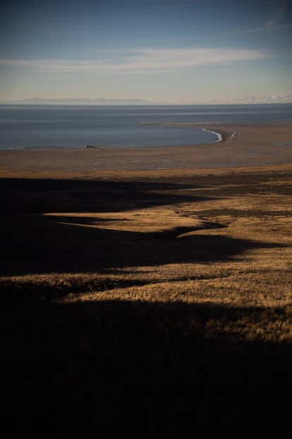
In the north of the lake lies Spiral Jetty – one of the most important works of American art of the 20th century and surely the most famous piece in the history of land art. Robert Smithson chose a truly remote point on the lake to draw a poetic spiral, using black basalt stones. The footage that the artist shot from a small plane after its installation in 1970 is proof of his original idea: for pink water to splash against the piece, which has inadvertently ended up becoming another beacon of decline in the place where it was installed.
The place looks a lot like the end of the world. Long ago, all of this was also water. Now, you have to walk for more than a mile to reach it.

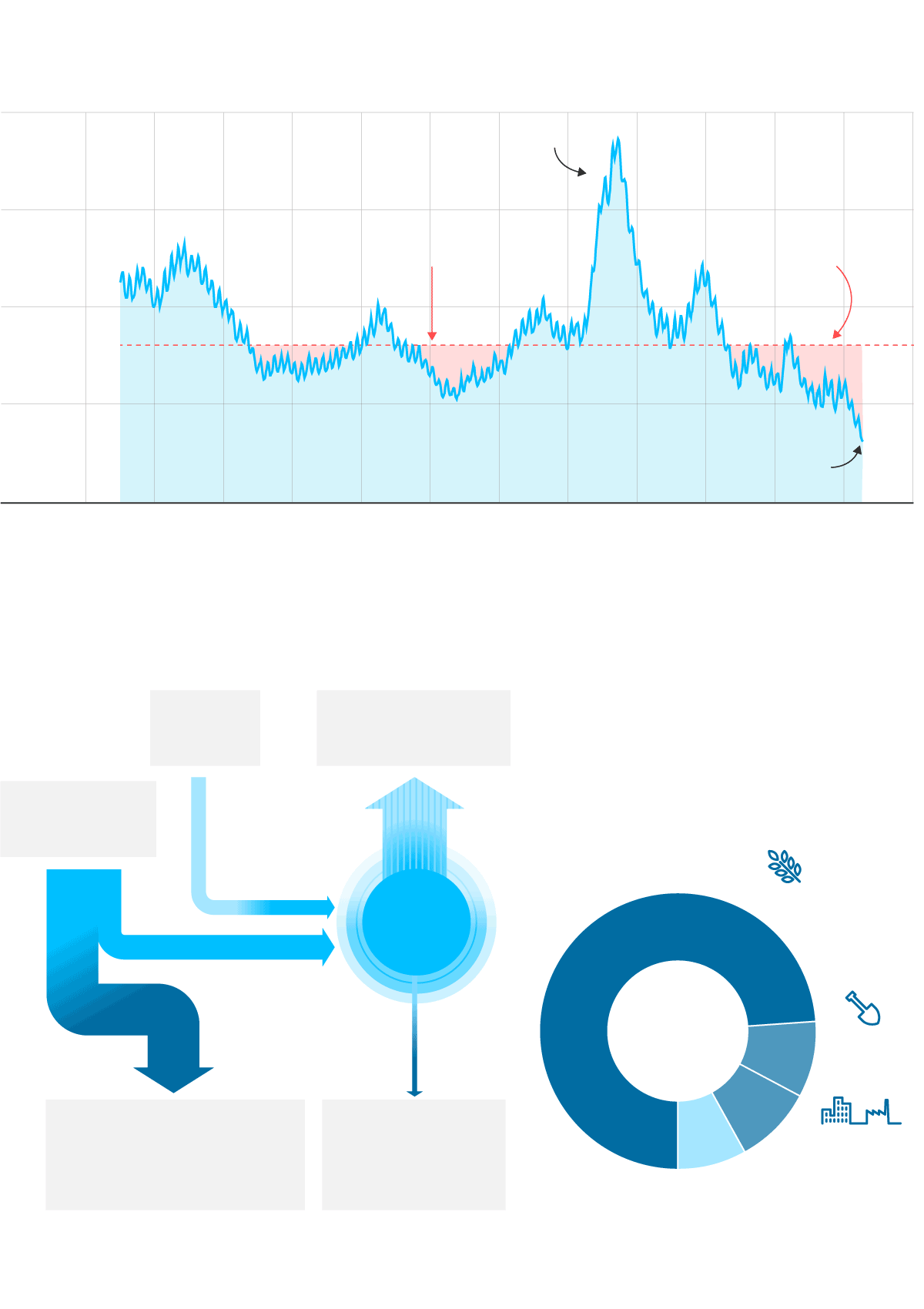
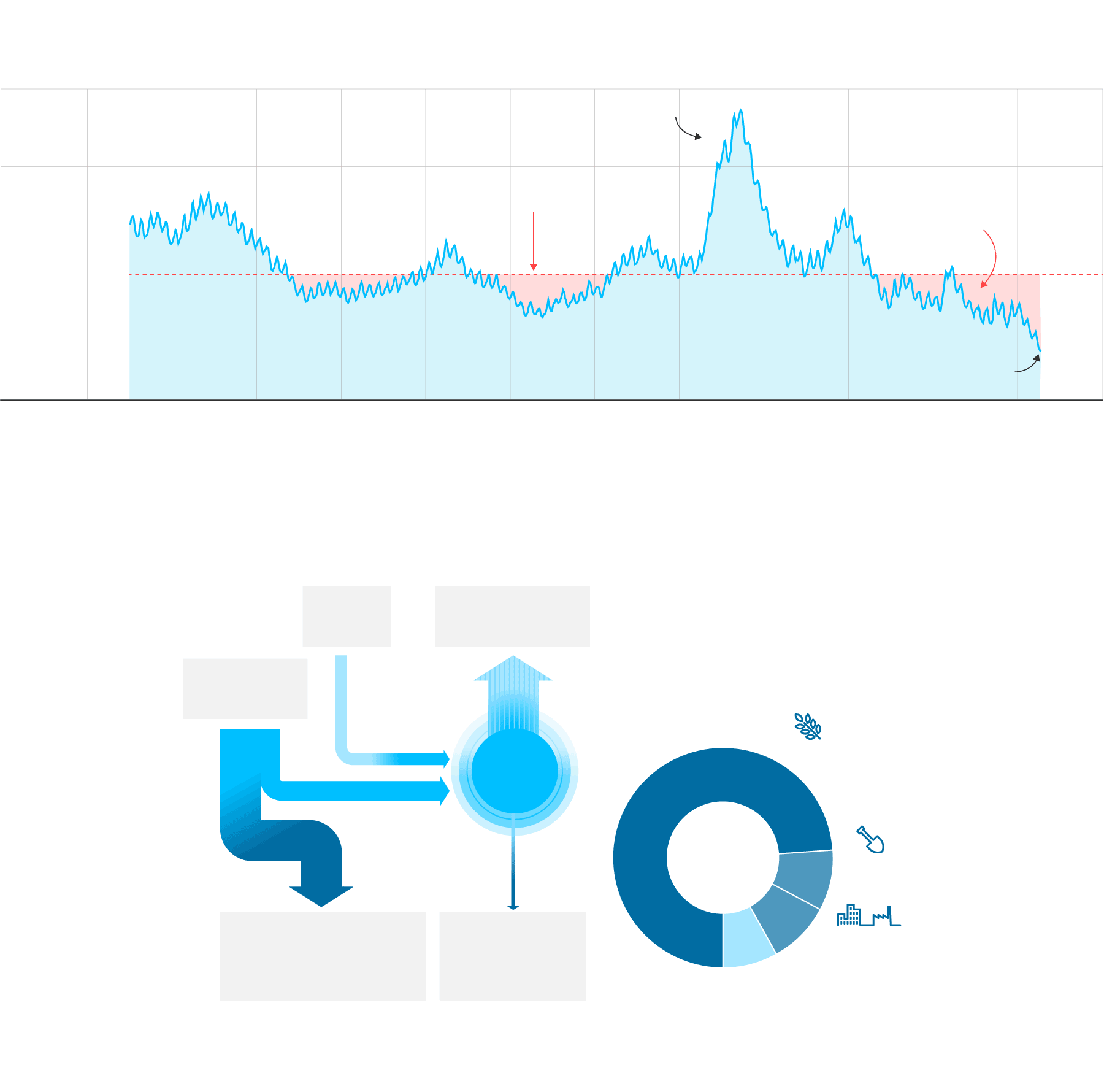
Volume of water
The 1980s were a period
of exceptional rainfall
40,000 Hm3
30,000
Minimum
value for
lake health
Periods
of water
deficit
20,000
10,000
Current levels
0
1920
1950
1980
2000
2022
Water balance
Annual estimate 2020-2022.
Cubic hectometers per year
Rain
740
Evaporation
3,207
Runoff
3,724
Great
Salt
Lake
1,234
Artificial upstream
diversions
2,590
Mining
extraction
247
Annual human consumption
(2020-2020 estimate)
2,837 Hm³
Agriculture
74%
Mining
9%
9%
8%
Urban use
and industry
Water loss
At these levels of water loss, the lake as we know it will be gone in five years.
Volume of water
The 1980s were a period
of exceptional rainfall
40,000 Hm3
30,000
Minimum
value for
lake health
Periods
of water
deficit
20,000
10,000
Current levels
0
1920
1950
1980
2000
2022
Water balance
Annual estimate 2020-2022.
Cubic hectometers per year
Rain
740
Evaporation
3,207
Runoff
3,724
Great
Salt
Lake
1,234
Mining
extraction
247
Artificial upstream
diversions
2,590
Annual human consumption
(2020-2020 estimate)
2,837 Hm³
Agriculture
74%
Mining
9%
9%
8%
Urban use
and industry
Water loss
At these levels of water loss, the lake as we know it will be gone in five years.
Volume of water
The 1980s were a period
of exceptional rainfall
40,000 Hm3
30,000
Minimum value
for lake health
Periods
of water
deficit
20,000
10,000
Current levels
0
1920
1930
1940
1950
1960
1970
1980
1990
2000
2010
2022
Water balance
Annual estimate 2020-2022. Cubic hectometers per year
Rain
740
Evaporation
3,207
Annual human consumption
(2020-2020 estimate)
2,837 Hm³
Runoff
3,724
Agriculture
Great
Salt
Lake
74%
1,234
Mining
9%
9%
Artificial upstream
diversions
2,590
Mining
extraction
247
8%
Urban
use and
industry
Water loss
At these levels of water loss, the lake as we know it will be gone in five years.
Volume of water
The 1980s were a period
of exceptional rainfall
40,000 Hm3
30,000
Minimum value
for lake health
Periods
of water
deficit
20,000
10,000
Current levels
0
1920
1930
1940
1950
1960
1970
1980
1990
2000
2010
2022
Water balance
Annual estimate 2020-2022. Cubic hectometers per year
Rain
740
Evaporation
3,207
Annual human consumption
(2020-2020 estimate)
2,837 Hm³
Runoff
3,734
Agriculture
Great
Salt
Lake
74%
1,234
Mining
9%
9%
Artificial upstream
diversions
2,590
Mining
extraction
247
8%
Urban
use and
industry
Water loss
At these levels of water loss, the lake as we know it will be gone in five years.
Sign up for our weekly newsletter to get more English-language news coverage from EL PAÍS USA Edition