The earthquake data that explains the volcanic eruption in Iceland
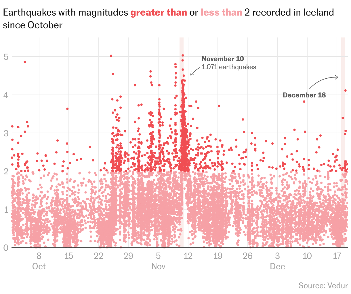
In November, more quakes were recorded on the island than on Monday, but the lava did not come to the surface
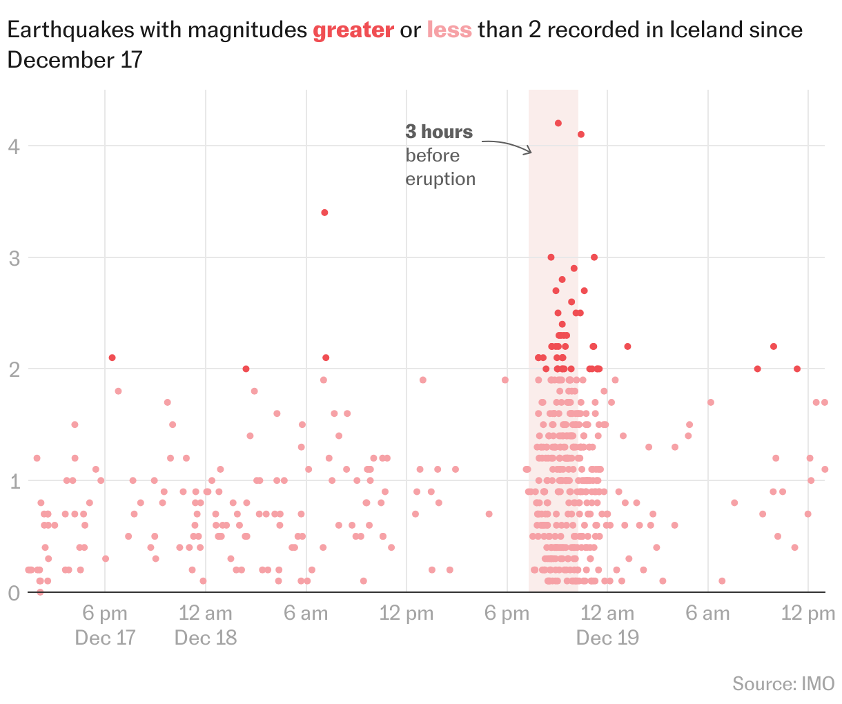
At 9:12 p.m. on Monday, a magnitude 4.2 earthquake shook Grindavik, a fishing town in southwest Iceland. More than an hour later, large fountains of lava bubbled up near Sundahnúkur crater, which was formed 2,350 years ago.
The magma came out of a 2.5-mile long fissure. It is not the classic volcanic cone that is typically associated with volcanoes, but rather a fracture in the rocks. The lava has been flowing out of this fissure and forming flat layers around it.
Seismic activity near the fissure decreased in the following hours, meaning so far there is no risk of international flight cancellations. The risk of such a scenario is also lower due to the fact that it is an effusive eruption. “These are eruptions where the lava is very fluid and moves very smoothly. As a rule, the presence of ash is very low,” geologist Nahúm Méndez Chazarra tells EL PAÍS.
In the three hours before the eruption, data from the United Nations International Maritime Organization indicates that at least 258 earthquakes were recorded. In the previous 24 hours, there were at least 450.
Authorities in Iceland were already aware of the risk of a possible eruption, and last month, evacuated the almost 4,000 inhabitants of Grindavik. They knew that an eruption was probable due to the seismic movement that had been recorded for almost two months.
Indeed, Iceland recorded greater seismic activity in November than on Monday. For example, between November 10 and 11, at least 1,071 earthquakes were recorded. So why was there no eruption? “We will not know until after some time, when scientists have collected all the data and can study it in detail,” explains Méndez Chazarra. “What’s more, although the system appeared calm, the ground deformation remained and seismic swarms were still occurring, which convinced the authorities to maintain the alert level in certain areas due to the possibility of an eruption.”
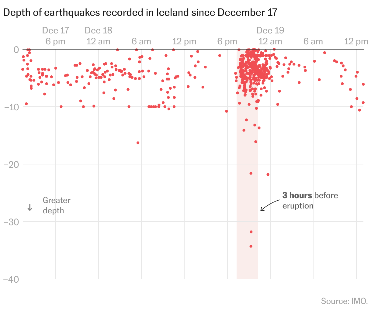
When monitoring earthquakes, one of the key factors is the depth at which they occur. “It tells us where the magma is moving and where it could be building up, as well as the area where it would have the most chance of breaking out to the surface,” explains Méndez Chazarra. In the two hours before Monday’s eruption, half a dozen quakes were recorded in the hundred meters closest to the surface.
The good news is that the eruption in the southwest of Iceland appears to have entered a state of equilibrium just a few hours after it began. An eruption further north, in the frozen areas of the island (there is hardly any ice in the south), would have been more dangerous. It was in the north where, in 2010, the Eyjafjallajökull volcano brought European air traffic to a standstill. This was an explosive — not effusive — eruption, where the lava being spewed from the volcano can turn into volcanic ash. If large amounts of volcanic air spread out through the atmosphere, it can lead to the closure of airspace.
Icelandic authorities claim that the intensity of the eruption began to decrease four hours after it began. With the exception of the site of the eruption, most of the parameters of the event are as expected. However, the Icelandic Meteorological Institute warns that it is possible that new magma vents will open along the original fissure.
Sign up for our weekly newsletter to get more English-language news coverage from EL PAÍS USA Edition