Tropical storm warning issued for US East Coast ahead of potential cyclone, forecasters say
The disturbance was located about 370 miles (595 kilometers) southeast of Charleston, South Carolina, forecasters said, and moving north at 9 mph (15 kph)
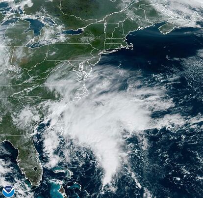
A tropical storm warning was issued Thursday from coastal North Carolina to Delaware ahead of a potential tropical cyclone that’s headed toward the East Coast.
The National Hurricane Center announced “Potential Tropical Cyclone Sixteen” on Thursday morning. The disturbance was located about 370 miles (595 kilometers) southeast of Charleston, South Carolina, forecasters said, and moving north at 9 mph (15 kph). Maximum sustained winds were 35 mph (55 kph).
The hurricane center defines a potential tropical cyclone as a disturbance that poses a threat for tropical storm or hurricane conditions to land within 48 hours. The current system could reach the North Carolina coast around Friday night or early Saturday.
The tropical storm warning is in effect from Cape Fear, North Carolina, to Fenwick Island, Delaware. It also includes the Chesapeake Bay south of Smith Point, and Albemarle and Pamlico Sounds.
Virginia emergency management officials warned of heavy rain, high winds and flooding in the next few days.
The Virginia Department of Emergency Management said on social media Thursday that officials are coordinating with local weather service offices to watch the system developing off the coast. Officials called on residents to prepare for the storm and impacts on the region throughout the weekend.
North Carolina Emergency Management warned that large swells from distant Hurricane Nigel also would reach the state’s coast on Thursday, boosting the rip current risk. The combination of those swells and the low-pressure system could mean additional ocean overwash, beach erosion and coastal flooding.
A storm surge watch was also issued from Surf City, North Carolina, to Chincoteague, Virginia. The hurricane center said storm surge between 2 and 4 feet (.6 to 1.2 meters) was expected.
Meanwhile, Hurricane Nigel was still moving quickly over the open waters of the Atlantic Ocean as a Category 1 storm. The hurricane center said Nigel’s maximum sustained winds were 85 mph (140 kph). The system was centered about 505 miles (815 kilometers) southeast of Cape Race, Newfoundland, and moving northeast at 30 mph (48 kph).
Forecasters expected Nigel would weaken over the coming days and could become a post-tropical cyclone on Thursday night or early Friday.
Sign up for our weekly newsletter to get more English-language news coverage from EL PAÍS USA Edition


