What civilian satellites are revealing about the war in Ukraine
The first efforts to peek beyond the Iron Curtain date back to the late 1940s. Since then, the technology has made significant advances, with military devices able to spot a soccer ball from an altitude of 200 kilometers

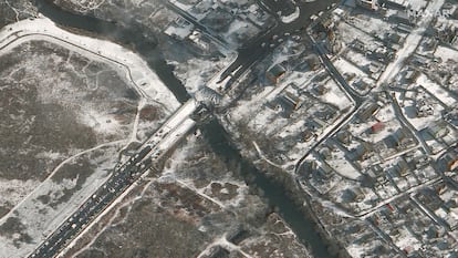
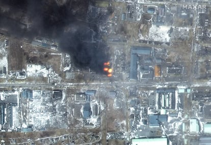
The photographs showing the armored convoys advancing towards Kyiv were taken by civilian satellites, not military ones. The latter have vastly superior technology and their footage has only been publicly revealed on a few rare occasions. One was as a result of espionage, as with the Samuel Loring Morison case in 1984, involving a US government official who leaked classified information to a news publication. Other times, military-grade photographs have been shared to support certain policies (like the images showing alleged hideouts used by Al Qaeda in Afghanistan and Sudan). Occasionally, “satellite” images have been offered up, but these have always been artificially degraded to conceal their true quality.
So how much detail can reconnaissance satellites pick up? Commercial ones, such as those developed by a company called Maxar, which is providing most of the imagery of the Ukraine conflict, offer a 50-centimeter per pixel resolution, which until recently was reserved for the military. The latter are believed to have up to 10-centimeter resolution, enough to spot a soccer ball from an altitude of 200 kilometers, although these satellites are typically in orbit far below that threshold.
Each image may come with another one showing the visible part of the sky, allowing viewers to precisely establish the satellite’s orientation at the time that the photograph was taken. These high-tech surveillance systems can also record video and operate in low-light conditions. Only clouds represent an insurmountable obstacle, but there are other kinds of satellites to deal with that: the ones equipped with synthetic aperture radar. These work kind of like gigantic photo cameras with a flash, and they can work day and night, pierce the cloud cover and even penetrate layers of vegetation covering the terrain.
A historic effort
The efforts to peek beyond the Iron Curtain go back a while. In the late 1940s, the United States created a program based on helium balloons to spy on the USSR, which was believed to have nuclear weapons. At an altitude of 15 kilometers, these balloons would listen to the infrasounds produced by an atomic explosion. These artifacts were launched from Alamogordo in New Mexico, and one of them reportedly dropped near the town of Roswell, leading to a popular story about a UFO.
The next step was to equip the balloons with cameras, launch them from European bases, and have the high atmospheric winds blow them over the Soviet Union for around a week before dropping into the Pacific Ocean. Over 500 balloons were launched but only one out of 10 reached its destination. The rest were shot down by Soviet aircraft at night, when the helium cooled down and the balloons lost altitude.
A lot of secret material fell into unexpected hands, like the film rolls contained in the cameras. These were resistant to cosmic radiation, a technology still unavailable in the USSR. In 1958, one of those film rolls was used in the Luna 3 Soviet spacecraft that was the first mission to photograph the far side of the Moon.
The balloon program lasted only a month instead of six as expected. These were replaced by the first U-2 planes, which proved very effective but were in clear violation of the Russian airspace. In 1960, one of these reconnaissance aircraft was shot down over the Soviet Union and it was such a humiliation for the Dwight D. Eisenhower administration, coming as it did just ahead of a meeting with Soviet leader Nikita Khrushchev, that Washington banned all future flights over Soviet territory.
The measure was a bit opportunistic, however, as the first spy satellites were about to become operational. This first generation was disguised under the name Discoverer, which officially was a scientific endeavor. They were flying cameras that would release a capsule with the film, which would, in turn, be “fished” out of the sky by airplanes or out of the sea by ships. And if nobody showed up for it in 24 hours, a vial of salt would dissolve and send the film to the bottom of the sea.
There were 13 attempts and many failed operations. But the next generation of satellites was fully operative and covered millions of square miles of Soviet territory in search of military facilities, especially the elusive missile launching pads that the Soviet leader had boasted about. They did not show up for the simple reason that they did not exist.
The first satellites offered resolutions of a few dozen meters, enough to locate aerodromes but not much more. This technology improved over the years, and by the late 1960s the satellites could already make out objects at a resolution of two meters, such as vehicles on roads.
Space telescopes
The next revolution took place in 1963, when a new model of satellites came into service. Instead of a conventional camera, these satellites used a telescope measuring around one meter in diameter. In optimal conditions, Soviet reconnaissance satellites – which were developed following the Vostok program that sent Yuri Gargarin into outer space – could also capture images of similar quality.
Ten years later, another, more advanced model was launched: the KH-9 Hexagon. Known unofficially as “Big Bird,” the satellite was the size of a bus. The quality of the images remained the same, but it had four re-entry vehicles with which to send the photographic film back to Earth. In total, it could carry between 30 and 50 kilometers of film, enough for more than six-month-long missions.

The last Big Bird was launched in April 1986, but the launch failed. It was the last satellite model that returned the photographic film to Earth. Since then, satellites have been using electronic cameras that send back images via radio-signal distribution.
The image quality of any system depends on the diameter of the object. In the case of space telescopes, it depends on the size of the mirror. It’s known that the first models measured 2.5 meters, like the Hubble Space Telescope, but there are suspicions that more advanced models could reach up to four meters. In 2012, the National Reconnaissance Office (NRO), which operates the reconnaissance satellites of the US federal government, donated two space telescopes to NASA, with a diameter of 2.5 meters, which were not in use.


