Panoramic twists and turns along the highways and byways of hidden Spain
Experience the thrills of Mallorca, Tenerife, Gran Canaria, and Lugo without ever having to leave your car
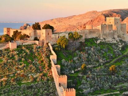
Sometimes remarkable coastal roads become tourist attractions, their level of allure directly proportional to how many bends and curves they have. A drive along one of these scenic routes guarantees impressive landscapes and dramatic views – and maybe a bit of vertigo, too.
Engineering feats
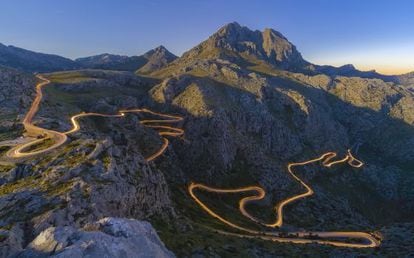
Sa Calobra, Escorca, Mallorca
As soon as you reach the first turn, you’ll see the way that the gray asphalt folds of the road have been inserted directly into the Tramontana mountain range. You’ll also see that Mallorcan engineer Antoni Pariette (1899-1979) went to great lengths to construct this winding highway without the use of any tunnels. The twelve-kilometer-long descent to Sa Calobra drops 900 meters, protected by walls and wooden railings. Particularly interesting is the 270 degree loop, called the “Nudo de Corbata” (Tie Knot), complete with a bar, although this drive is harrowing enough without any alcohol in the system. Many tourists like to get out and walk a few meters along the side of the road to photograph the almost hyper-realist view.
The narrowness of the road requires compromise between cyclists and the fifty buses that will sometimes drift into the oncoming lane, at least at the twelve points where the turn is a full 80 degrees. Since Sa Calobra is a popular spot to break for lunch during a daytrip to the mountains, the buses usually descend in greatest number around 11:30 and return between 13:30 and 15:30. Once at the pier, you have to visit the beautiful “Torrente de Pareis” (Twin Streams), a gorge that’s home to one of the most difficult hikes on the island of Mallorca. Tuent cove is another must, where you can grab a bite to eat at Es Vergeret as well as take a dip in the crystal clear waters.
Dragon’s tail
La Aldea-Agaete, Gran Canaria
The highway GC-200, traversing the 35 kilometers between La Aldea and Agaete, snakes in between crags and seesaws over cliffs, practically radiating the sweet aroma of adventure. Start at the Balcón Lookout, just in front of the vertigo-inducing drop-offs, and begin your zigzag along the coastal road shaped like a dragon’s tail – at some point, you’re sure to encounter Tomás’s caravan offering water and sweet mango. After climbing 600 meters, you’ll reach the spectacular stretch called Andén Verde (Artenara), where you can park just before the sign or further ahead at the bus stop. You’ll find the glittering, ancient beach of Las Arenas, the impressive Roque Faneque, and the western coastline of Gran Canaria. Stop at El Risco for a quick tapita de queso at the bar Perdomo.
Upon entering Guayedra ravine, pay attention to the recycling containers and trash bins, which you can follow on foot to descend to the naturist beach. This visit will surely offer an unforgettable view.
From the laurel forest to the sea
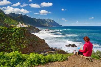
Taganana, Santa Cruz de Tenerife
The descent to the little town of Taganana in the rocky Guanche region is one of the most stunning secrets of Tenerife. Beyond the laurel forest and the sea of clouds floating above it, the TF-134 tunnel dominates this stretch of climates in transition, leading towards the northern slope of the peninsula of Anaga. Despite the reassuring side rails, the 5-kilometer serpentine descent demands respect and induces vertigo, freely following the natural ridge down the mountain. At the 2-kilometer point, the Amogoje lookout offers a view almost too beautiful to be real, found at the base of a promontory where some claim to see a lion’s face etched into the massive rock. The view opens out to the Atlantic, including the Roque de Fuera and Roque de Dentro. The houses of Taganana stand out like white stains on the green landscape, molded to the bends and whims of the terrain.
If you follow the highway down, you can climb the Roque de las Bodegas at Almáciga beach after savoring the grilled fish and fried octopus of El Frontón (+34 922 59 02 38). Finish off the excursion by passing through Benijo beach and enjoy an evening’s stay in the town of Taganana, waiting until morning to make your way out of the labyrinth.
Beach route
Ribadeo/Barreiros, Lugo
Sign up for our newsletter
EL PAÍS English Edition has launched a weekly newsletter. Sign up today to receive a selection of our best stories in your inbox every Saturday morning. For full details about how to subscribe, click here.
The Mariña Lucense highway starting at Rinla is flat and more or less straight, consisting of 10 kilometers where there’s nothing more to do than [*ensartar abanicos] from the sand. Start at Os Castros, the Ribadeos’ preferred beach for taking in some sun, and continue to As Illas, where you’ll need low tide to explore the islets and the strange, marvelous rocky formations that adorn them. After a stop at the iconic beach Las Catedrales (which you’ll have to make a reservation to see), leave Ribadeo and enter the town of Barreiros via the wooden footbridge. From Arealonga beach, arrive at As Pasadas, where you can stop by an exhibition center built entirely from recycled materials by the handless artist Celso Dourado.
Hop over to Lóngara beach, where a section of the beach is closed off just for surfers and the curious can observe their stunts from the ledge above. Follow along Balea, Fontenla and especially the Coto sandbank, which extends languidly, uninterrupted by buildings and flanked by sand dunes. Finally, end the day at the islet of Altar beach, which offers a breathtaking view of the mouth of the Masma river and where it's possible to stroll along the shore even at high tide.
English version by Allison Light.