The Spanish Civil War and Google Street View
New project blends images from the siege of Madrid with modern-day photos of the capital
When General Francisco Franco and other rebel army officers launched a coup in July 1936 their principle military objective was to take Madrid. By early September, the roads to the Spanish capital from the south, west and north had been taken, and it seemed the city would fall within days. Instead, Franco chose to relieve Toledo, some 70 kilometers southwest of the capital, where nationalist forces were holed up in the city’s Alcazar fortress. The delay allowed the communist-led authorities in Madrid to prepare defenses, and after bitter fighting in November, Franco’s forces were held off. Rather than launch another full-frontal attack, over the next 28 months he instead subjected the city to constant and indiscriminate shelling and aerial bombardment, with the help of Germany’s Luftwaffe. In all, some 15,000 civilians would be killed and wounded, and by the end of the siege, much of the population was reduced to starvation.
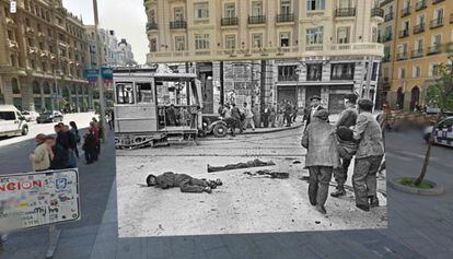
Eight decades later, large parts of Madrid are unchanged, as a series of montages using photographs taken during the blockade superimposed over Google Street View show.
“It’s like reality slapping you in the face,” says Sebastian Maharg, a US writer and history buff responsible for the images, who came up with the idea after seeing a similar series of montages created to commemorate this year’s 70th anniversary of the Normandy Landings. “They leave you stunned while the brain tries to assimilate two realities, two periods of time in the same place. They leave you with the sensation of traveling through time for an instant. They remind you how unaware we are of what surrounds us. People died on the same pavements we walk down every day.”
Of Scottish and Spanish parentage, Maharg was born in Chicago. His maternal grandfather was a teacher in the tiny village of Aldea del Obispo in Salamanca, and fought for Franco’s forces and was killed in Extremadura in 1939. “The photographs are there, they’re not hard to find, but a lot of people are surprised when they see these montages because they are not used to looking into the past,” says Maharg, who says he found it difficult to locate the sites of some of the most important battles in the Spanish Civil War.
“In Paris or Berlin, there are guided tours to explain to people what happened during the war, but there is nothing like that in Madrid: it’s still taboo.” That is why he decided to use Google Street View: “It’s a tool that we all use every day to get around,” he explains. But the service has its limitations, he adds, saying that he now intends to develop the project and take his own photographs of Madrid based on images from the Civil War and merge them. “In some cases it’s obvious where events have taken place, but in others I’ll have to track them down; that’s what makes this so interesting.”